TeleOrbit, Founded in 2001 and based in Nuremberg, Germany, is a specialist in satellite navigation (SATNAV) and mobile locating systems, a niche the company refers to as Locatineering. With a mission to bridge global GNSS capabilities and real-world applications, TeleOrbit develops and manufactures GNSS front-ends, multi-frequency receivers, and positioning platforms for industries ranging from automotive and defense to telecommunications and rescue services. Leveraging partnerships with institutions like Fraunhofer IIS and TeleConsult Austria, the company combines deep engineering expertise with practical consulting. Its highly trained team delivers customized GNSS solutions, supporting everything from receiver architecture to ESA and EU-funded projects.
SATNAV-Technologies
1. MIDS (Mobile Interference Detection System): MIDS is a mobile system designed to detect, analyze, and classify interference in GNSS signals. It enables field operators to detect and analyze GNSS signal jamming inexpensively, helping secure navigation systems and counter spoofing. It plays a crucial role in safeguarding navigation and timing systems from intentional or accidental disruptions. Its portability and cost-efficiency make it ideal for field investigations and security-critical applications.
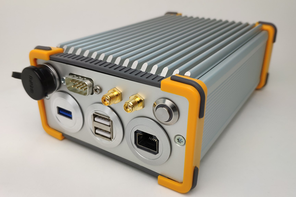
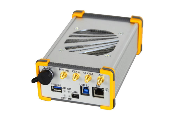
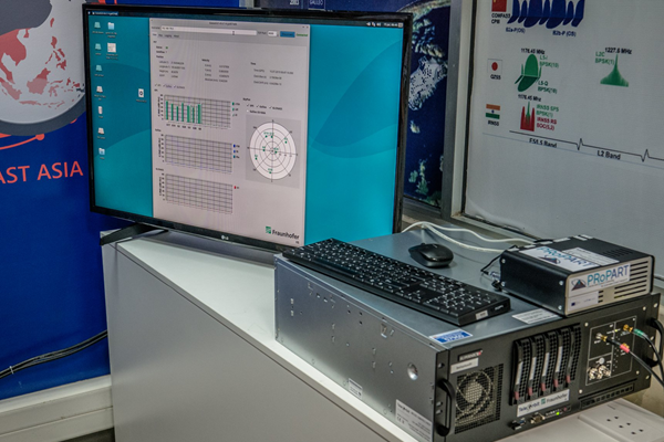
2. MGSE (Multi-GNSS Software Environment): MGSE is a flexible GNSS RF front-end and signal simulator that supports multiple GNSS constellations across various frequency bands. It allows developers to replay or generate GNSS signals in real-time for testing and validation. This ensures precise and reproducible simulation environments for GNSS receiver development. This enables lab-based testing and receiver validation under controlled or recorded conditions critical for qualifying GNSS equipment.
3. MGSE REC: The MGSE REC is a dedicated GNSS RF recorder that captures real-world GNSS signal environments. These recordings can be replayed for lab simulations using the MGSE system. This tool is essential for realistic validation and troubleshooting of GNSS receivers.
4. MGSE 2.0: An advanced version of the original MGSE, MGSE 2.0 provides extended capabilities in signal recording, simulation, and hardware interfacing. It offers modular integration for different RF front-ends, enabling detailed scenario-based testing. It supports full-bandwidth signal acquisition across multiple constellations.
5. GOOSE (GNSS Open On-board Software Environment): GOOSE is an open, modular platform for GNSS development and integration, combining hardware and software elements. It supports multi-system and multi-frequency configurations for flexible research, testing, and product development. Ideal for R&D institutions, it allows easy interfacing with user-defined algorithms. A modular GNSS hardware/software platform featuring an open interface ideal for developers and mobile communication systems.
6. XPLORA: XPLORA is a software-defined GNSS signal simulator offering real-time and scenario-based emulation across GPS, Galileo, BeiDou, and other systems. A multi-system, multi-frequency GNSS simulator, capable of emulating complex scenarios across major constellations and SBAS, enabling comprehensive testing from L1 to L6 frequency bands. It enables the evaluation of GNSS performance in complex environments like urban canyons or spoofing zones. Its software interface is customizable and user-friendly.
7. Two-Element GNSS Antenna Array: This GNSS antenna array enables basic direction-finding by comparing signal phase differences across two antenna elements. It’s used in applications requiring angular resolution and is effective in environments with multipath interference. The system enhances situational awareness in GNSS navigation.
8. Six-Element GNSS Antenna Array: Designed for high-precision orientation and beamforming, this array allows advanced GNSS signal processing including interference mitigation and spoofing detection. It supports a broader field-of-view and is ideal for autonomous platforms and critical missions. The increased element count improves accuracy and resilience.
9. AMELIE: AMELIE is a modular software platform designed for IoT-based location tracking and monitoring. It offers seamless integration with GNSS hardware and supports data collection, visualization, and geofencing functionalities. This platform is widely used in fleet management, logistics, and environmental monitoring applications. It supports integration with various sensors and mobile devices, providing real-time data and analytics. It is highly scalable and suited for fleet management, logistics, and remote monitoring applications. Solutions designed for high-precision applications and IoT platforms, enabling reliable positioning in challenging environments via GNSS signal diversity and redundancy.
Products and Services
- HERE HD-GNSS Positioning: The HERE HD-GNSS service offers high-definition positioning by combining GNSS signals with correction data, enabling centimeter-level accuracy. This solution is ideal for autonomous driving, drone operations, and smart agriculture, where reliable, real-time positioning is critical. Its integration-ready interface makes it suitable for OEM deployment and scalable mobility platforms. Provides high-definition positioning through advanced augmentation and corrections designed for precision-dependent industries like agriculture, surveying, and autonomous systems.
- SARONTAR: SARONTAR (Situation Awareness and Risk Observation through New Technologies Applied to Rescue) is a situational awareness system that merges GNSS positioning with real-time data streams. It is primarily used by emergency services and rescue teams to enhance coordination, geolocation, and resource tracking during crises. The system supports secure, encrypted data communication over mobile and satellite networks. A positioning system combining SAR (Synthetic Aperture Radar) data with GNSS for enhanced navigation in environments where GNSS alone is insufficient (e.g., dense urban canyons, forests).

TeleOrbit has contributed to multiple high-impact projects, leveraging their Locatineering expertise. For example, the MGSE simulation suite built in collaboration with Fraunhofer IIS and TeleConsult Austria is a cornerstone of GNSS receiver validation for European and global markets. TeleOrbit, in conjunction with RobNav GmbH, won the 2024 EUSPA CASSINI Challenge, developing a GNSS-based Guidance, Navigation and Control (GNC) module featuring OSNMA and E6 security underscoring their specialization in secure navigation. With its innovative SATNAV technology, precise positioning solutions, and collaborative projects, TeleOrbit continues to lead in GNSS-based navigation and location services.