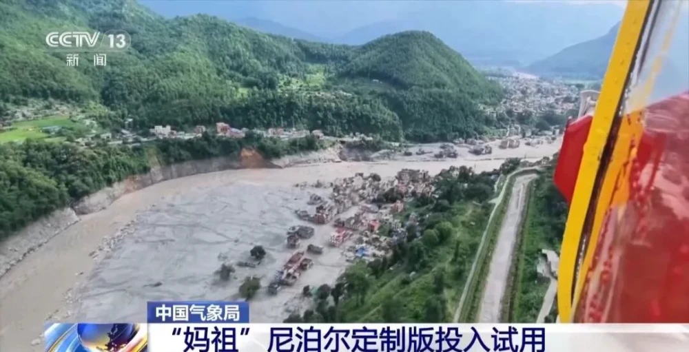
On Aug. 26, a high-altitude ice-and-rock avalanche occurred on the Nepalese side of the border, triggering a chain of cross-border debris flows that caused significant casualties and left people missing at Gyirong Port in China’s Gyirong County. Following the disaster, the China Meteorological Administration activated the Fengyun International User Disaster Prevention and Mitigation Emergency Support Mechanism (FY_ESM), intensified satellite observations and multi-source data analysis, and used China’s MAZU intelligent weather-warning system to provide Nepal with multi-source satellite data and products from the Fengyun-3 and Fengyun-4 series. These efforts supported cross-border disaster monitoring and emergency meteorological services between China and Nepal.
Fengyun satellites track precipitation and severe weather
The National Satellite Meteorological Center, which also oversees China’s space-weather monitoring and warning activities, has continued monitoring the affected area with China’s Fengyun satellite constellation.Around Gyirong Port and other affected locations, the center conducted enhanced Fengyun-4B observations and combined multiple products, including cloud-image animations, convective initiation monitoring and precipitation estimates.
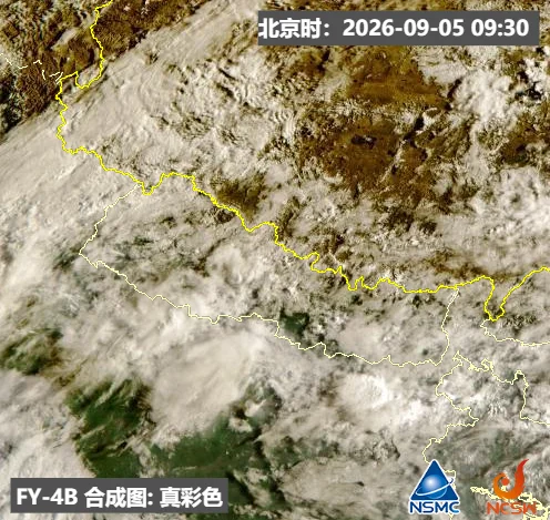
The National Satellite Meteorological Center, which also serves as the National Space Weather Monitoring and Warning Center, has continued monitoring the disaster-affected areas in Nepal using China’s Fengyun meteorological satellite series. True-color imagery from the Fengyun-4B satellite showed extensive cloud cover over the disaster zone, with convective cloud clusters developing in some areas.
The response also incorporated lightning observations from Fengyun-4C and precipitation products from Fengyun-3G. Together, these datasets provided frequent updates on the evolution of rainfall systems and convective weather around the high-altitude border region.
Fengyun satellites are particularly useful in areas where ground-based observations are difficult to maintain. Their broad coverage and repeated observations can reveal the development and movement of weather systems beyond the range of local weather stations, while lightning and precipitation products provide indicators of strengthening convection and potentially hazardous rainfall.
High-resolution imagery supports terrain and river analysis
China also coordinated with relevant organizations to obtain high-resolution imagery from the Gaofen, Environmental Disaster Reduction and Resources satellite series. These data were used to monitor the upstream avalanche area and river channels and to compare conditions before and after the disaster.
Analysts produced three-dimensional imagery, river-channel change assessments and maps of barrier-lake distribution. Such products can help emergency authorities determine whether debris has obstructed a channel, identify changes in the flow path and assess the potential for additional flooding or downstream impacts.
Satellite-based terrain analysis is especially valuable in steep Himalayan valleys, where cloud cover, unstable slopes and damaged or inaccessible roads can limit direct surveys. Optical imagery can provide detailed surface information when conditions permit, while repeated observations help identify changes in river corridors and newly formed accumulations.
Nepal Customized Version of MAZU Enters Trial Operation
At Nepal’s request, the China Meteorological Administration further strengthened its support through cross-border data products. Following the disaster, the China Meteorological Administration promptly deployed compact ground observation stations and mobile weather radars near the affected area to strengthen local weather monitoring. It also rapidly developed a Nepal-customized version of MAZU, integrating AI-powered weather forecasting models such as Fenglei, Fengqing and Fengshun, together with geographic information on Nepal’s rivers and glacial lakes, to support Nepalese forecasting efforts. The customized service system developed for Nepal has now been connected in real time with Fengyun meteorological satellite products, including rapid-scan imagery and satellite-based lightning data.
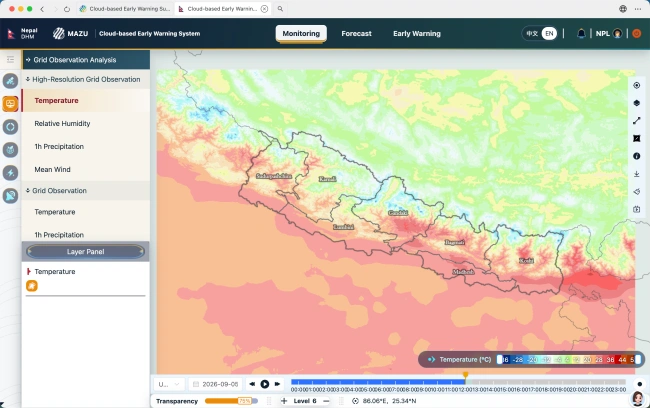
This image shows the monitoring interface of the Nepal-customized version of the MAZU cloud-based early-warning system. It displays the National Meteorological Information Center’s ART-1km high-resolution real-time air-temperature analysis product. The map clearly shows the detailed spatial distribution of temperatures across Nepal: the southern plains are dominated by red and orange tones, indicating relatively high temperatures, while broad areas of blue appear across the Himalayan mountains in the north, reflecting much lower temperatures at higher elevations. The pronounced temperature gradient between the southern plains and northern mountains illustrates the influence of terrain and provides fine-gridded, real-time support for weather monitoring and disaster early warning in Nepal.
Rapid-scan imagery combines high temporal and spatial resolution, allowing forecasters to follow detailed cloud structures and localized weather features. Frequent updates are intended to support real-time monitoring of rapidly developing convection and lightning across Nepal, including areas outside the immediate disaster zone.
The National Meteorological Information Center’s global 5-km hourly real-time analysis products have been integrated into China’s MAZU intelligent weather early-warning solution. In addition, 1-km high-resolution, multi-source fused real-time analysis products covering temperature, humidity, wind and precipitation have been incorporated into the customized Nepal version of MAZU, providing real-time services to Nepal.
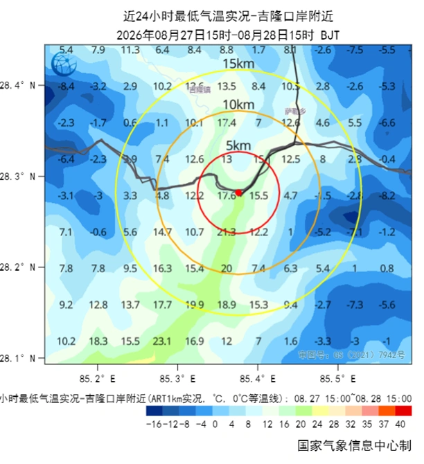
Observed minimum temperatures near Gyirong Port from 07:00 on Aug. 28 to 07:00 on Aug. 29. Data source: China’s 1-km hourly temperature analysis product.
Virtual soundings fill high-altitude observation gaps
Focusing on Gyirong Port and the disaster-affected areas, the National Meteorological Information Center expanded the provision of multi-source, multidimensional real-time analysis products. These include 1-km, 10-minute surface meteorological analysis products and 3-km, 10-minute three-dimensional atmospheric analysis products covering China and surrounding regions.
“The products can monitor key meteorological conditions in real time, including upper-level atmospheric circulation, moisture transport and convective instability energy, forming a multi-variable, multi-layered and three-dimensional real-time observation support system. This helps provide an accurate picture of weather conditions in and around the disaster-affected areas,” said Zhang Zhiqiang, a senior engineer at the National Meteorological Information Center.
At the same time, the center issues two rolling data-service bulletins each day and prepares the Weather Conditions Analysis Bulletin for the Gyirong County Debris-Flow Disaster Area. From 9:00 a.m. to 9:00 p.m. daily, it provides hourly real-time products for the disaster-affected area, overlaid with topographic information, at two-hour intervals, continuously updating key variables including precipitation, temperature and maximum wind gusts.
To address observational gaps in key areas, the National Meteorological Information Center has leveraged its expertise in multi-source real-time data fusion to establish an initial three-dimensional real-time monitoring and service system covering the disaster area and surrounding regions. The system combines national and local resources, complementary data from within and outside China, and both surface and upper-air observations.
“Drawing on integrated real-time analysis technology, the products can provide meteorological variables such as temperature, air pressure, humidity and wind for any location, effectively compensating for insufficient observations in key areas,” Zhang Zhiqiang said.
To address the lack of upper-air sounding data around Gyirong Port, the center has also introduced virtual sounding and vertical-profile products to provide additional information on the vertical structure of upper-air thermal conditions, moisture and wind fields. These products help offset shortcomings caused by sparse observation stations in the high-altitude border region, limited data from areas outside China, and inadequate surface and upper-air observing capabilities in complex terrain. They provide timely and high-resolution meteorological support for disaster monitoring and early warning, science-based emergency response operations, and efforts to prevent secondary hazards such as flash floods.
Cross-border data support emergency coordination
As of Sept. 5, Chinese meteorological agencies had produced more than 10 English-language monitoring and analysis reports based on multi-source satellite remote-sensing data, while continuing to provide Nepal with satellite monitoring products and technical support.
The response highlights the value of combining different types of Earth observation and meteorological data in a time-critical disaster. Rapid-scan imagery can reveal the evolution of convective systems, high-resolution optical or radar imagery can document changes on the ground, and fused real-time analyses can fill gaps between sparse observation points. The most effective solution is therefore not necessarily the highest-resolution image, but the combination of data types and resolutions that best fits the operational task.
That principle also applies beyond emergency response. STARPATH GLOBAL’s satellite imagery catalog allows users to explore optical, multispectral, hyperspectral, stereo and SAR imagery by application, resolution and sensor capabilities, helping them identify data suited to specific monitoring needs. For organizations that need help defining the problem before selecting data, STARPATH GLOBAL’s Pioneer Partner Program starts with opportunity discovery and solution co-creation, then supports pilot validation and ROI assessment before any formal procurement decision.