Information current as of August 28, 2026. The disaster mechanism, casualty figures, and damage estimates remain subject to revision as field investigations continue.
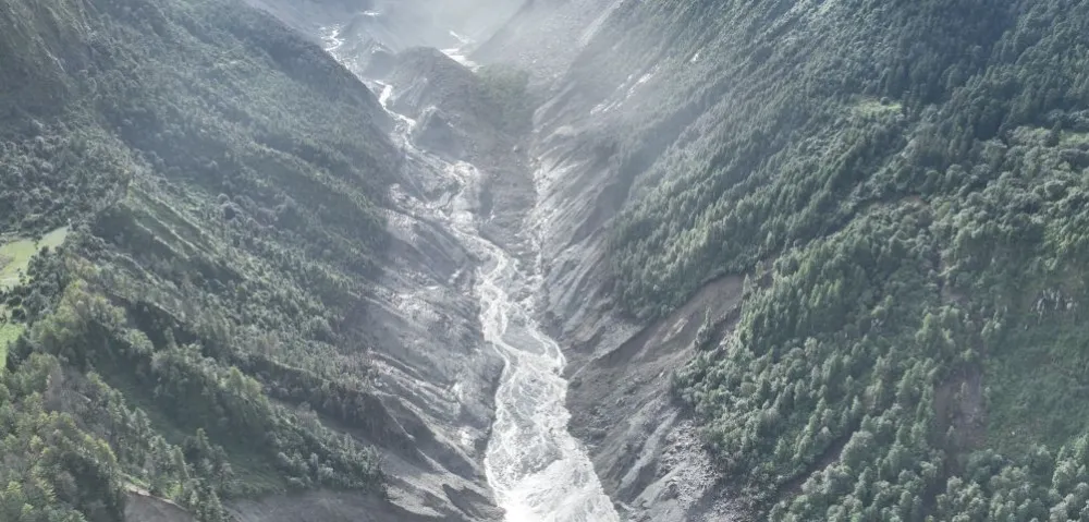
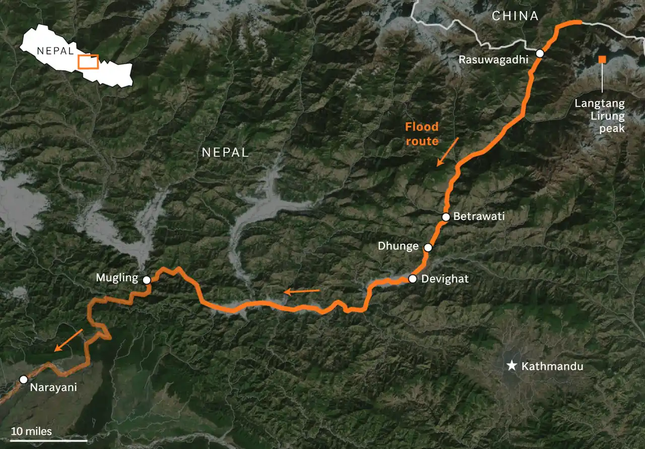
On August 26, 2026, a devastating flood and debris-flow disaster struck the Himalayan region along the border between China’s Xizang Autonomous Region and Nepal. Fast-moving floodwater, sediment, and boulders swept through narrow mountain valleys, causing heavy loss of life and leaving large numbers of people missing or unaccounted for. Communities, roads, bridges, border facilities, power systems, and communications networks along the affected corridor were severely damaged.
As of August 28, search-and-rescue operations and casualty verification were still underway, with reported numbers of fatalities and missing persons continuing to change. Damaged roads, disrupted communications, and temporarily inaccessible communities have made it difficult to establish a complete picture of the human and infrastructure losses.
The challenges created by this disaster extend far beyond search and rescue. When roads, electricity supplies, and terrestrial communications fail at the same time, emergency authorities must answer a series of interconnected questions:
Where did the flood originate? Why did it occur so suddenly? Do new hazards remain upstream? Which communities are cut off or unreachable? Which roads and bridges can still be used? How badly have hydropower plants, transmission lines, and other critical infrastructure been damaged? And when on-site communications are unavailable, how can rescue teams transmit information back to command centers?
Under such extreme conditions, satellite imagery, geospatial data, and satellite communications are no longer simply supporting technologies. They become essential infrastructure for maintaining the flow of disaster information and supporting emergency decision-making.
In this response, satellite data have already been used to investigate the source area, document broad patterns of damage, observe evolving upstream hazards, and support emergency mapping. China’s National Space Administration reported that, by August 27, five pre-disaster and ten post-disaster satellite images had been distributed to emergency-management, water-resources, mapping, and disaster-reduction agencies.
A Cross-Border Cascading Disaster, Not an Ordinary Flash Flood
The final triggering mechanism of the disaster remains under investigation.
After the event, damaged roads initially prevented ground teams from reaching the upstream source area. Weather, terrain, and infrastructure destruction further constrained field investigations. Satellite imagery therefore became an important source of evidence for tracing the disaster to its origin and reconstructing how it unfolded.
Preliminary analysis of pre- and post-disaster imagery from Planet Labs and other sources revealed a major loss of glacier ice and mountainside material at high elevation. As clouds and dust from the collapse began to clear, more detailed images suggested that the failure involved not only glacier ice but also a substantial section of the underlying bedrock.
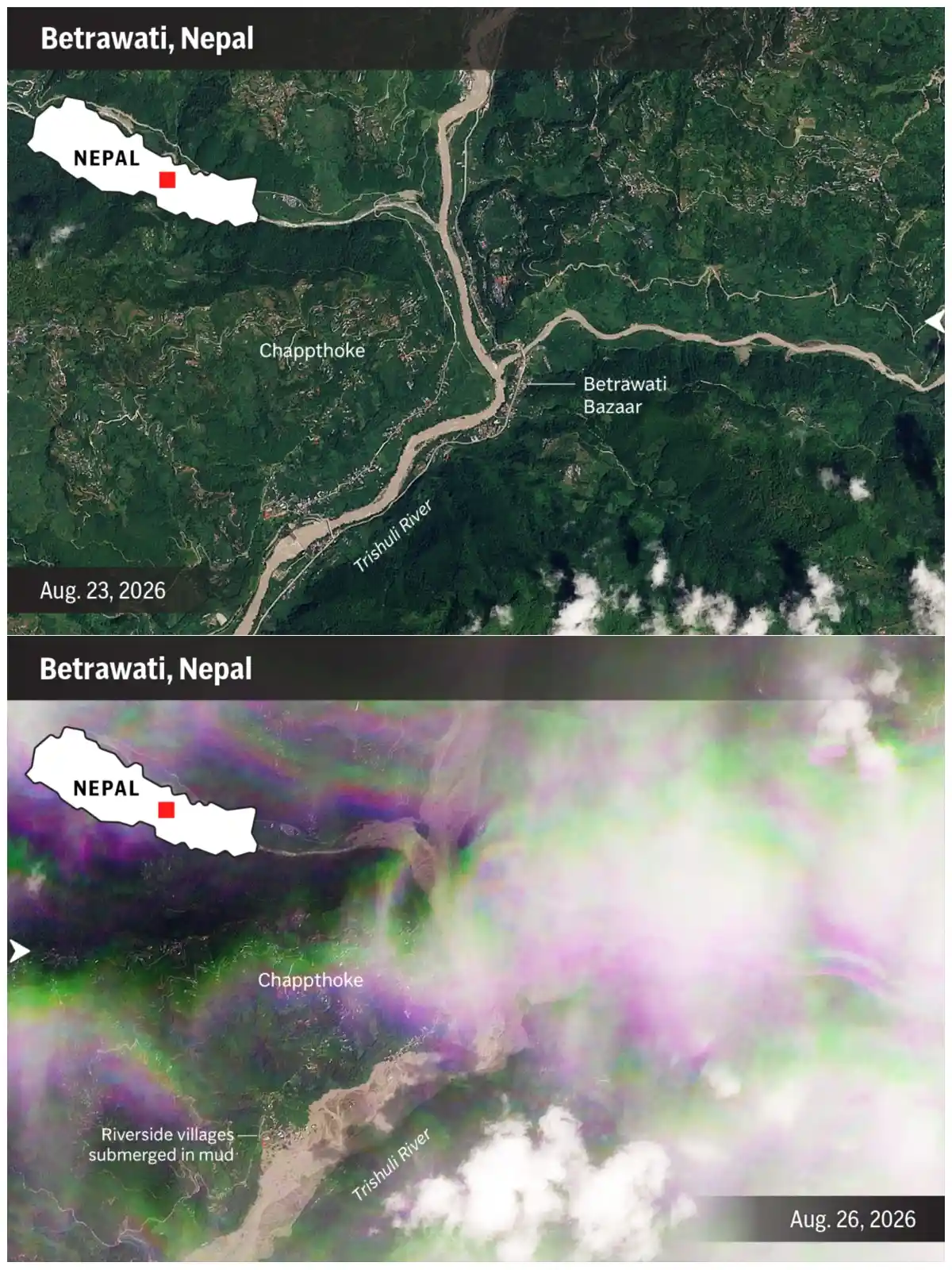
Available official and scientific assessments currently support a preliminary reconstruction involving a cascading high-mountain hazard process:
High-altitude ice-rock collapse
→ Entrainment of glacial and slope material
→ Entry into the upper Lhende Khola drainage
→ Temporary river blockage and water impoundment
→ Rapid release by overtopping, erosion, or partial blockage failure
→ Downstream flood and debris-flow impacts
The existence of this general sequence is increasingly supported by satellite and field evidence, but the duration of the blockage, the volume of impounded water, and the relative contributions of ice, rock, river water, and sediment have not yet been conclusively determined.
Nepalese authorities, drawing on preliminary satellite analysis and information shared by Chinese counterparts, reported that the suspected source area lay approximately 20 kilometres northeast of the Rasuwagadhi–Gyirong border crossing. They assessed that ice, rock, and debris may have temporarily blocked the river before a sudden downstream release.
ICIMOD has described an ice-rock avalanche as a likely trigger while emphasizing that the event remains under investigation. A conclusive reconstruction will require the integration of satellite imagery, hydrological and seismic records, terrain analysis, and field evidence.
In other words, satellite imagery first helps answer:
Where might the flood have originated? How might it have formed? And where should investigators focus next?
From a “Seismic Signal” to an Ice-Rock Collapse: How Multiple Data Sources Explain an Anomaly
The U.S. Geological Survey initially registered a seismic event near the affected area. Early automated and media reports treated the signal as a possible earthquake, leading to speculation that tectonic shaking might have triggered the collapse. Subsequent USGS analysis concluded that the signal was more consistent with seismic energy generated by the glacier and rock collapse and the resulting debris flow, rather than a tectonic earthquake that preceded the disaster.
This event illustrates the complementary roles that different datasets can play in investigating a complex high-mountain disaster:
- Seismic stations indicate that strong ground motion occurred.
- Optical satellites show how the glacier, mountainside, and valley changed.
- Digital elevation models, or DEMs, help determine the likely movement path of ice and rock.
- Hydrological data record the arrival time of the flood peak and changes in water level.
- Drones, ground videos, and field investigations verify the actual downstream damage.
A single sensor can detect an anomaly. Multiple sources are needed to explain it.
No inpidual dataset can fully explain the entire disaster process. Only by placing these observations within a common spatial and temporal framework can investigators gradually reconstruct where the collapse occurred, how material entered the valley, how the flood propagated downstream, and which areas were affected.
For emergency management authorities, the objective is not simply to possess as much data as possible. What matters is whether different data sources can be connected quickly enough to produce a mutually reinforcing assessment that supports the next operational decision.
Turning Post-Disaster Imagery into Rescue Priorities
The value of satellite imagery goes beyond showing a visual difference between conditions before and after a disaster.
By combining pre- and post-disaster imagery with road, settlement, river, terrain, and infrastructure data, detected changes can be converted into geospatial information that directly supports rescue operations.
Publicly documented uses in this response include source-area investigation, broad damage assessment, barrier-lake observation, and support for emergency mapping. Subject to image resolution, cloud cover, acquisition timing, and field verification, additional analysis can help identify:
- Damage to buildings and border-crossing facilities;
- Disruption of roads, bridges, and major transport nodes;
- River widening, channel shifts, and sediment accumulation;
- Damage to hydropower plants, transmission lines, and construction facilities;
- Communities isolated by flooding or landslides;
- Roads and bridges that may remain usable;
- Open areas that could serve as temporary logistics points or helicopter landing zones;
- Areas at elevated risk of secondary landslides, slope failure, or renewed flooding.
These analytical results can support different operational decisions.
Information about damaged roads and bridges can help rescue teams identify alternative access routes. The location of isolated settlements can inform priorities for helicopter rescue and supply delivery. Areas with concentrated building damage can help define priority search zones. Damage assessments for hydropower and transmission infrastructure can support the sequencing of power restoration and critical infrastructure repairs.
Nepal’s preliminary power-sector assessment indicated that approximately 430 MW of generation capacity had been affected or taken offline, including about 405 MW across 11 hydropower projects and a 25 MW solar facility. This figure refers to affected or unavailable generating capacity, not capacity confirmed as permanently destroyed. Related substations, transmission lines, distribution systems, and project facilities were also reported damaged. Field verification remains indispensable as access is restored, while satellite analysis can help identify locations requiring priority inspection.
In other words, the real value does not come from a single satellite image. It comes from the process of converting imagery into action:
Change detection → Preliminary damage layers → Accessibility screening → Risk and confidence classification → Field-verification priorities
Satellite analysis can help indicate, “Which locations may require priority attention or field verification?” Ground teams then determine, “What has actually happened there, and what action can be taken safely?”
Is the Disaster Over? Satellites Help Track Continuing Secondary Risks
The passage of the first flood wave does not mean that the danger has fully passed.
Post-event surveys identified a barrier lake associated with debris blockage in the affected upstream area. Chinese water authorities estimated that the impounded water volume had reached approximately two million cubic metres by the morning of August 27 and warned that continued inflow could increase the risk. Authorities subsequently issued warnings for potentially affected downstream areas. Because the estimate was preliminary and conditions remained dynamic, continued monitoring was required to assess the lake’s volume, drainage state, and stability.
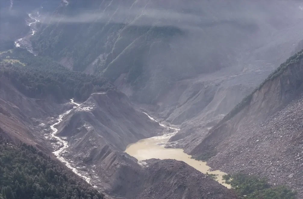
Copernicus Sentinel-2 imagery acquired on August 27 showed the accumulation of a barrier lake at the glacier-collapse site, providing an open-source satellite reference for observing its location and surface extent. Assessing how the lake is evolving—and whether the blockage is becoming more or less stable—requires repeated observations combined with rainfall, water-level, discharge, terrain, and field data.
This situation demonstrates why satellite-supported emergency response cannot end after a single post-disaster image is acquired.
Multi-temporal monitoring is needed for unstable impounded water bodies, slopes, and river channels, with particular attention to:
- Changes in the area and extent of the impounded water body;
- Changes in upstream inflow and rainfall;
- Observable surface changes near the blockage, including erosion, channel development, or displacement;
- River outlets and drainage conditions;
- Newly visible slope failures, exposed ground, or other surface changes;
- Potential impacts on downstream communities and rescue facilities.
Repeated observations can help emergency authorities assess whether observable risk indicators are declining, remaining broadly stable, or intensifying.
Keeping Disaster Information Moving When Ground Networks Fail
The disaster also severely damaged local power and communications infrastructure. Telephone and internet services were interrupted in some areas, making it difficult for rescue personnel to maintain reliable contact with field teams.
An official notice from the Xizang Autonomous Region Bureau of Geology and Mineral Exploration and Development stated that geological teams deployed to the affected area carried drones, satellite phones, geological monitoring equipment, and surveying instruments. These tools were intended to support disaster verification, dynamic monitoring, hazard inspection, and the assessment of secondary disaster risks.
China’s Ministry of Emergency Management reported deploying “Xinglitong” emergency communications equipment and “Citan Jingling” aeromagnetic survey equipment. The communications equipment supported connectivity in the field, while the aeromagnetic equipment was deployed for technical survey and rescue support.
Telecommunications authorities also reported deploying satellite phones and portable satellite terminals while terrestrial networks were being repaired. By late August 27, one base station had been restored, two additional stations had been deployed, and limited communications coverage had returned near Resuo village. Together, these measures illustrate a layered emergency-communications strategy: satellite systems provide temporary or supplementary connectivity while damaged terrestrial networks are progressively restored.
When terrestrial base stations, fiber connections, and power systems are damaged, satellite phones and dedicated emergency communications terminals can provide a basic communications channel that operates independently of the affected local network. Depending on terminal availability, bandwidth, power supply, and field conditions, such systems can support:
- Communications between rescue teams and command centers;
- Reporting on people, roads, and infrastructure;
- Transmission of critical coordinates and hazard locations;
- Coordination of medical evacuation and supply delivery;
- Organization of drone and mapping missions;
- Delivery of updated risk assessments to field personnel.
Satellite communications cannot fully replace normal terrestrial networks. Bandwidth, available equipment, and operating conditions in the field all impose limitations. In a disaster zone, the most valuable information is therefore not always a large volume of unprocessed raw data. It may instead be accurate coordinates, structured damage reports, risk classifications, and compressed situational maps.
Satellite remote sensing helps responders see and understand. Satellite communications help critical information continue moving through a damaged environment. Together, they help maintain the basic information chain between the field and the command center.
Disasters Cross Borders—Risk Information Must Connect Across Them
This was not the first severe high-mountain flood to affect this border valley.
On July 8, 2025, the same Rasuwa–Gyirong cross-border corridor experienced a serious flood triggered by the rapid drainage of a supraglacial lake. That disaster caused deaths and missing persons and damaged the China–Nepal Friendship Bridge, roads, border facilities, hydropower plants, and electricity infrastructure. After nearly six months of repairs, Gyirong Port resumed operations in January 2026. Several months later, the same cross-border corridor was struck by another catastrophic event with substantially broader reported human and infrastructure impacts.
These repeated events indicate that the corridor is exposed to recurring and interacting high-mountain hazards rather than a single isolated event. It is confronting a complex and evolving system in which the cryosphere, mountain slopes, rivers, communities, and infrastructure are closely interconnected.
Regional inventories of glaciers, glacial lakes, and potentially dangerous glacial lakes already provide an important foundation for regional risk monitoring. China, Nepal, and relevant regional institutions are also advancing cooperation in glacial-lake monitoring, flood early warning, disaster-risk reduction, information sharing, and community preparedness.
During this event, Chinese authorities shared upstream technical and satellite-based hazard information with their Nepalese counterparts, while relevant agencies and researchers coordinated the review of satellite evidence from the source area. Information provided by China contributed to Nepal’s assessment of the continuing upstream risk and supported warnings for potentially affected downstream communities. This exchange illustrates the practical value of timely cross-border information sharing during a rapidly evolving disaster.
Building on these foundations, the region could further explore the development of an operationally updated cross-border common operating picture that connects existing datasets, scientific cooperation, and warning information more closely.
Such a mechanism could include:
- A shared baseline covering glaciers, glacial lakes, unstable slopes, rivers, settlements, transport links, and critical infrastructure;
- Agreed indicators and alert thresholds for observable changes such as lake expansion, slope displacement, river blockage, and rapid water-level rise;
- Standardized coordinates, time references, place names, confidence levels, data sources, and update intervals;
- Predefined procedures for cross-border notification, field verification, backup communications, and joint emergency exercises.
Disaster processes are geographically continuous. An upstream collapse can affect downstream border facilities, villages, and infrastructure after a very short warning interval. Risk information therefore needs to move continuously along the same river valley.
The long-term objective is not only to obtain imagery more quickly after a disaster, but also to integrate space-based information into risk management at an earlier stage. Where meaningful changes are observable, indicators such as slope displacement, glacial-lake expansion, or river blockage can inform predefined triggers for expert review, field verification, risk communication, and protective action.
Keeping Information Moving When It Is Needed Most
Search-and-rescue operations and damage verification remain underway on both sides of the China–Nepal border.
We extend our sincere concern to all communities affected by this disaster. We hope rescue operations can proceed safely, that more missing people are found alive, that displaced residents receive timely support, and that essential services—including roads, water, electricity, and communications—are restored as soon as possible.
Satellite data cannot replace field rescue personnel, local knowledge, or ground investigation. Cloud cover, mountain shadows, revisit intervals, data latency, and complex terrain can all affect remote-sensing analysis. Satellite imagery alone cannot determine whether every blockage will fail or predict precisely when a disaster will occur. Its greatest value lies in complementing these capabilities—especially when roads are blocked, sites are difficult to reach, communications are interrupted, and the hazard environment continues to change. Under these conditions, satellite and space-based information can provide a wide-area, persistent, and relatively independent source of intelligence, helping emergency authorities understand what has happened, how risks are evolving, and where limited rescue resources should be deployed first.
STARPATH GLOBAL combines optical, SAR, and other multi-source satellite observations with terrain, environmental, and field information to develop decision-support geospatial products for disaster assessment, infrastructure monitoring, and operational risk management.
For organizations responsible for remote, mountainous, or cross-border infrastructure, our team can help assess where satellite data may strengthen damage assessment, accessibility analysis, infrastructure monitoring, and the tracking of evolving hazards over time. Discuss a Satellite-Based Disaster Assessment or Mountain-Infrastructure Monitoring Pilot →