Why do some satellites skim relatively close to Earth and complete an orbit in just over 90 minutes, while others remain above the equator and appear motionless in the sky? And why do some Earth observation satellites designed for near-global coverage deliberately use “retrograde” orbits with inclinations greater than 90 degrees?
The answer lies in two of the most common—and most frequently misunderstood—orbital parameters: orbital altitude and orbital inclination.
The short version is this: altitude primarily determines how far a satellite is from Earth, affecting orbital period, resolution, coverage, latency, atmospheric drag, and the radiation environment. Inclination determines how much the orbital plane is tilted relative to the equator and directly limits the latitudes that the satellite’s ground track can reach. Together, these two parameters are still not enough to fully define an orbit, but they already reveal much of what a satellite is intended to do.
1. Orbital Altitude: Where Is It Actually Measured From?
Reports often say that a satellite “operates in a 500-kilometer orbit.” That is perfectly understandable in everyday language, but from an engineering perspective, the first question is: 500 kilometers relative to what reference surface?
Orbital mechanics begins with the satellite’s distance from the center of Earth. Let this distance be r. Only when Earth is approximated as a sphere with radius RE can the commonly cited orbital altitude h be approximately written as:
h ≈ r − RE
This assumes a spherical Earth; r is the geocentric distance, and RE is the selected mean Earth radius.
Earth is not a perfect sphere: its equatorial and polar radii differ. When a reference ellipsoid is used, geodetic height is generally defined along the ellipsoid normal, so it cannot simply be calculated by subtracting an “ellipsoid radius in that direction” from the geocentric distance. For precise orbit determination, reentry analysis, and payload geometry calculations, the coordinate system, height definition, reference ellipsoid, and epoch must all be specified. In popular descriptions, however, a “500-kilometer orbit” is usually just a simplified description of a near-circular orbit.
If the orbit is nearly circular, its altitude changes little during each revolution, so using a single average altitude is convenient. If the orbit is significantly elliptical, both the perigee altitude and apogee altitude must be specified. In that case, the quantity that actually determines the orbital period is not a simple “average altitude,” but the semi-major axis. Under the ideal two-body approximation:
T = 2π √(a³ / μ)
T is the orbital period, a is the semi-major axis, and μ is Earth’s standard gravitational parameter.
As orbital altitude increases, orbital velocity generally decreases, yet the satellite takes longer to complete one revolution. A satellite in low Earth orbit at an altitude of several hundred kilometers typically circles Earth in roughly an hour and a half, while a geostationary satellite takes one sidereal day—about 23 hours, 56 minutes, and 4 seconds—to complete an orbit.[1][2]
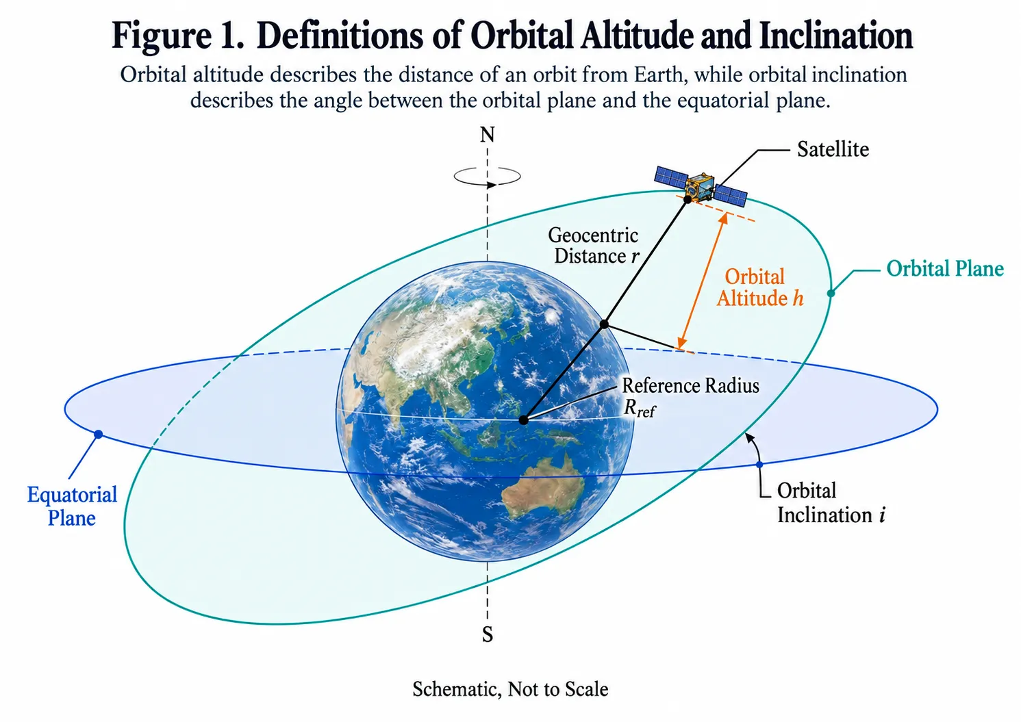
Altitude describes the scale of an orbit, while inclination describes the tilt of its orbital plane. Source: Illustration created by the author.
What Do Lower and Higher Orbits Trade Off?
For an optical Earth observation satellite using the same camera, lowering the orbit generally reduces the ground sampling distance, potentially improving spatial resolution. But it also narrows the area visible to a single satellite, increases atmospheric drag, and places greater pressure on orbit maintenance and mission lifetime.
For a low Earth orbit communications satellite, shorter distance means relatively lower propagation latency and path loss, but more satellites and orbital planes are generally required to provide continuous coverage.
At higher altitudes, a single satellite can see a larger portion of Earth, while atmospheric drag rapidly decreases. At the same time, launch energy requirements, propagation latency, path loss, and the radiation environment also change.
Altitude is therefore never simply a matter of “lower is more advanced” or “higher means fewer satellites.” It is a trade-off among competing mission requirements.
2. Orbital Inclination: It Is Not the Angle of the Satellite’s Nose
Imagine an orbit as a ring surrounding Earth. The invisible plane containing that ring is the orbital plane. It passes through Earth’s center. In an ideal two-body problem, gravity always points toward Earth’s center, so it does not pull the satellite out of this plane; the satellite follows a circular or elliptical path within it.
How Is the Orbital Plane “Tilted”?
Imagine first placing the orbital plane directly on the equatorial plane. Then choose a line passing through Earth’s center as a hinge and tilt the orbital plane upward. The resulting angle is the orbital inclination.
That hinge is the line where the two planes intersect, known as the line of nodes. The point where the satellite crosses the equatorial plane from south to north is the ascending node, while the opposite crossing is the descending node.
Inclination therefore does not define the orbital plane by itself. It only tells us how much the plane is tilted. A circular orbit inclined at 45 degrees can still be rotated around Earth’s axis into many different orientations. The right ascension of the ascending node (RAAN), Ω, specifies that orientation. Multiple orbital planes in a constellation often share the same inclination but have different RAAN values.
An inclination of 0 degrees corresponds to a prograde equatorial orbit, while 90 degrees corresponds to an ideal polar orbit. Inclinations between 0 and 90 degrees are prograde, while those between 90 and 180 degrees are retrograde. In a 45-degree orbit, the satellite does not repeatedly “turn” north and south. Instead, it continuously travels along the same inclined orbital plane, passing over the Northern Hemisphere, the equatorial region, and the Southern Hemisphere.
With a Fixed Inclination, How Can a Satellite Observe Different Places?
Over short periods, the orbital plane remains approximately fixed in inertial space, while Earth rotates beneath it. By the time the satellite completes one orbit, a different part of Earth has rotated underneath, so the ground tracks of consecutive revolutions do not overlap.
For a low Earth orbit satellite with a period of about 95 minutes, Earth rotates by roughly 24 degrees during one revolution. As a result, the next ground track on a map will typically be shifted westward by approximately 24 degrees.
Inclination controls the latitudinal limits of these ground tracks. A prograde orbit with a 45-degree inclination has a subsatellite point that reaches roughly 45°N and 45°S. A 90-degree polar orbit can pass over the poles. A retrograde sun-synchronous orbit with a 98-degree inclination has a maximum ground-track latitude of about 82 degrees.
Earth’s rotation changes which longitudes the satellite passes over, but it cannot overcome this latitudinal limit.
A real camera does not observe only a narrow line directly beneath the satellite. Instead, it scans a strip with a certain swath width along the ground track and may also be capable of off-nadir pointing. Successive orbital passes gradually assemble these strips into regional or global imagery. A single low-inclination satellite cannot observe the entire planet simply by relying on Earth’s rotation.
Geosynchronous orbits provide another interesting case. For a geosynchronous satellite, non-zero inclination primarily creates north-south motion in its ground track, while orbital eccentricity mainly produces east-west motion. Together, they can produce a figure-eight pattern. An ideal geostationary satellite, by contrast, remains above a fixed longitude on the equator.[3]
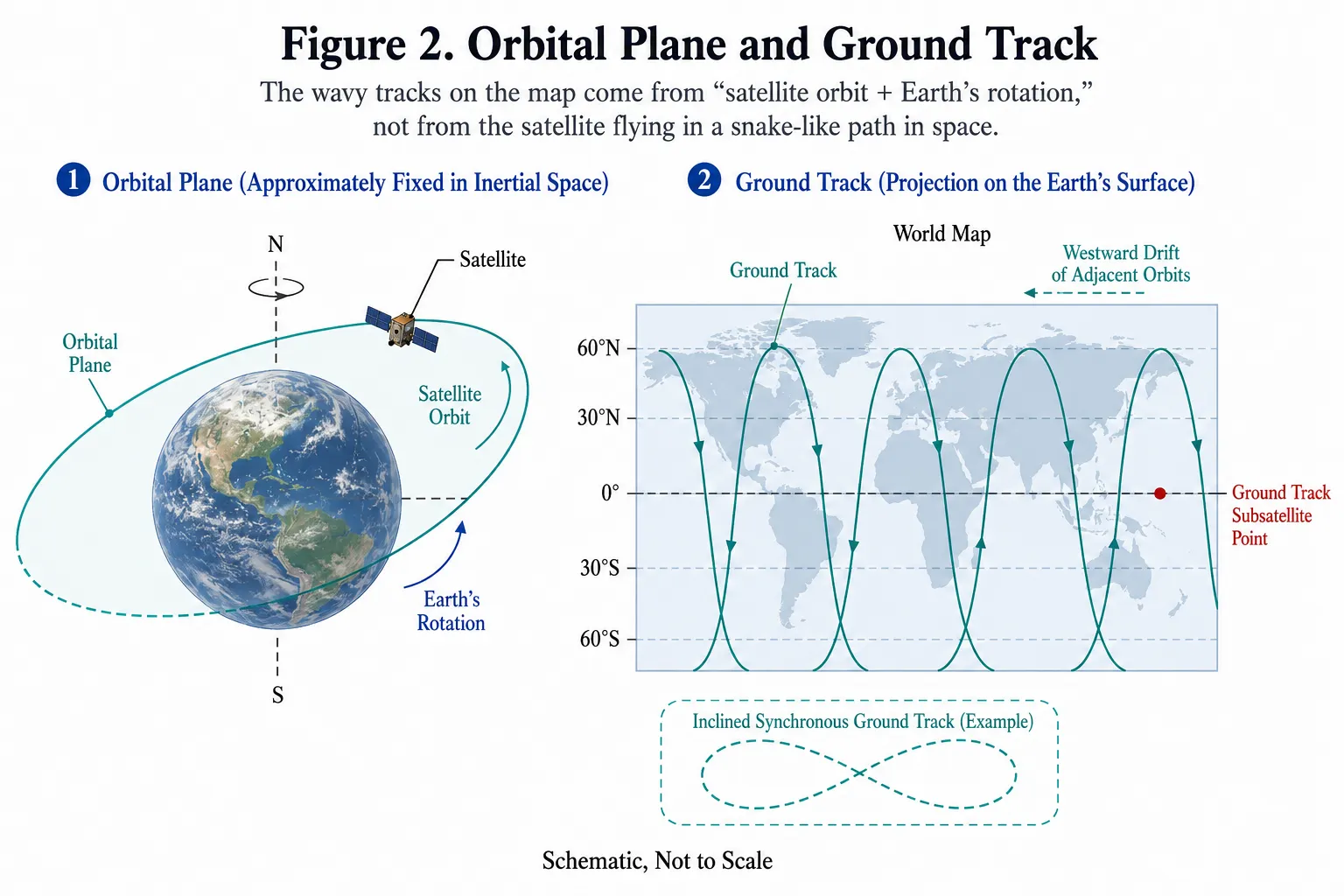
Inclination describes how much the orbital plane is tilted, while RAAN describes its orientation. The light-blue band represents the payload swath along the satellite’s ground track. Source: Illustration created by the author.
3. Why Is Inclination Usually Determined Before Launch?
Changing altitude requires energy, but changing the orbital plane can be particularly expensive.
For an ideal instantaneous plane change in which orbital speed remains constant, the required velocity change can be approximated as:
Δv = 2v sin(Δi / 2)
This assumes an instantaneous, pure plane change at the intersection of the two orbital planes, with equal speeds before and after the maneuver. Here, v is the velocity at the maneuver point and Δi is the angle between the orbital planes.
In low Earth orbit, satellites travel at roughly 7–8 kilometers per second. Changing inclination by even a few degrees can therefore consume a substantial amount of propellant.
Mission designers consequently try to achieve the required inclination through the launch site latitude, launch azimuth, and launch vehicle flight profile, rather than placing the satellite into orbit first and asking it to make an expensive sideways turn.
Under ideal conditions, launch-site latitude constrains the minimum inclination directly achievable through an eastward launch. Higher-latitude launch sites generally provide easier access to high-inclination orbits, although suitability for sun-synchronous missions also depends on permitted launch azimuths, drop zones, population and air-route safety, and the launch vehicle’s cross-range maneuvering capability. Lower-latitude sites, meanwhile, are better positioned to exploit Earth’s rotation for low-inclination and geosynchronous missions.[4][5]
This also explains why the same launch vehicle may have different payload capacities when delivering identical satellites to orbits with different inclinations. A launch does not simply lift a satellite to a particular altitude—it must also give it the correct velocity direction.
4. What Problems Do Common Orbit Types and Inclinations Solve?
1. Low Earth Orbit: Close to Earth, but Not a Fixed Inclination
The European Space Agency commonly describes low Earth orbit, or LEO, as extending to approximately 2,000 kilometers in altitude, with the practical lower boundary constrained by atmospheric drag.[1]
LEO can include low-inclination, medium-inclination, polar, and retrograde sun-synchronous orbits. “Low Earth orbit” therefore does not describe a single way of flying.
China’s space station operates in low Earth orbit at roughly 400 kilometers with an inclination of about 41.5 degrees. The International Space Station operates at an altitude that generally varies between roughly 370 and 460 kilometers, with an inclination of 51.6 degrees.[6][7]
Both are crewed space stations, but their different launch sites, transportation systems, and mission architectures led to different orbital inclinations. Their altitudes are also affected by atmospheric drag and require periodic reboosts rather than remaining permanently fixed at a single round number.
2. Polar and Sun-Synchronous Orbits: Similar North-South Paths, Different Concepts
A polar orbit is defined primarily by having an orbital plane close to 90 degrees of inclination. As Earth rotates beneath it, the satellite can gradually observe nearly the entire planet.
A sun-synchronous orbit adds another requirement: its orbital plane must precess by roughly one degree per day, allowing the satellite to pass over the same area at approximately the same local solar time.
Sun-synchronous orbits exploit the J2 perturbation caused by Earth’s equatorial bulge. As a result, typical low Earth sun-synchronous orbits are retrograde, commonly with inclinations of about 97–99 degrees. ESA gives a representative example of approximately 700 kilometers altitude and 98 degrees inclination.[8]
A consistent local solar time is useful when comparing optical imagery acquired on different dates because solar elevation and shadow conditions remain more similar.
Sun-synchronous, however, does not mean “always in sunlight.” Whether the spacecraft enters Earth’s shadow still depends on the season, orbital plane, and direction of the Sun.
3. Medium Earth Orbit: Navigation Constellations Balance Coverage and Satellite Count
The nominal BeiDou-3 constellation includes three types of satellites: MEO, IGSO, and GEO spacecraft. Its MEO satellites operate at an altitude of 21,528 kilometers with an inclination of 55 degrees. Europe’s Galileo satellites operate in circular MEOs at an altitude of 23,222 kilometers and an inclination of 56 degrees.[9][10]
At these altitudes, each satellite covers a much larger area than a LEO spacecraft. Multiple inclined orbital planes can also provide users worldwide with favorable satellite visibility and positioning geometry.
4. Geosynchronous, Geostationary, and Inclined Geosynchronous Orbits Are Not the Same Thing
The defining characteristic of a geosynchronous orbit is an orbital period equal to one sidereal day. Such an orbit may have non-zero inclination and eccentricity.
An ideal geostationary orbit must simultaneously be circular, prograde, have an inclination of zero degrees, and have a period equal to one sidereal day. Only then does the satellite appear stationary above a particular longitude on the equator, at an altitude of approximately 35,786 kilometers.
In actual operations, north-south and east-west station-keeping maneuvers keep the satellite within its assigned longitude and latitude control window.[1][3]
BeiDou’s IGSO satellites operate on the same general altitude scale of 35,786 kilometers but have an inclination of 55 degrees. Their ground tracks form figure-eight patterns, helping improve navigation geometry and satellite visibility over China and surrounding regions.[9]
In other words, “synchronous” describes the orbital period, while “stationary” imposes additional requirements on orbital shape and inclination.
5. Highly Elliptical Orbits: Using Slow Motion Near Apogee to Serve High Latitudes
A highly elliptical orbit does not attempt to maintain a constant altitude. Instead, it takes advantage of the satellite’s slower motion near apogee to keep the spacecraft over a particular region for longer periods.
The Molniya orbit is a classic example. It has a period of approximately 12 hours and an inclination of 63.4 degrees, with its apogee positioned over the Northern Hemisphere. This provides extended visibility over high-latitude regions where geostationary satellites appear relatively low on the horizon.[11]
The 63.4-degree value is also a critical inclination, helping suppress long-term rotation of the argument of perigee caused by Earth’s non-spherical gravitational field.
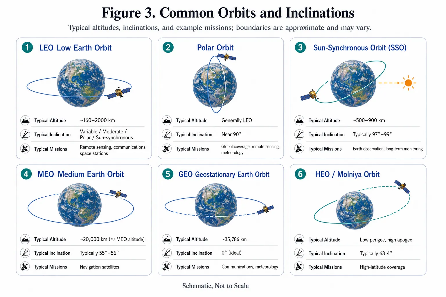
Typical altitudes, inclinations, and applications of common orbit types. Boundaries and values vary by mission and should not be treated as universal design templates. Source: Illustration created by the author.
5. How Do Mission Requirements Determine Altitude and Inclination?
Orbit design usually does not begin with the statement, “We want to fly at 500 kilometers.” Instead, engineers work backward from mission requirements.
For Earth observation, designers first consider target latitudes, spatial resolution, swath width, revisit time, and illumination consistency. Flying lower can improve imaging detail, but reduces coverage and increases atmospheric drag. Too little inclination prevents access to high latitudes. Long-term optical monitoring may also require a sun-synchronous orbit with a specific local solar time.
For satellite communications, user distribution, latency, capacity, and continuous coverage become more important. Global services require orbital planes with sufficient inclination to reach the relevant latitudes. Systems serving only a specific latitude band may use more targeted inclinations to reduce unnecessary coverage. Lowering the altitude shortens the time each satellite can serve a given area, increasing constellation size, handover requirements, and network replenishment pressure.
Navigation constellations aim to ensure that users can simultaneously see multiple satellites with favorable spatial geometry. Their altitude, inclination, number of orbital planes, and inter-satellite phasing must therefore be designed together.
Space stations must additionally account for crew transportation, cargo resupply, launch-site accessibility, reentry safety, and long-term operations.
Engineering teams must also consider launch capability, orbital injection errors, station keeping, tracking and control windows, thermal conditions, radiation exposure, collision risk, and end-of-mission disposal.
The result is not a single “best altitude,” but a set of orbital parameters and allowable tolerances that can be achieved and maintained throughout the mission lifetime.
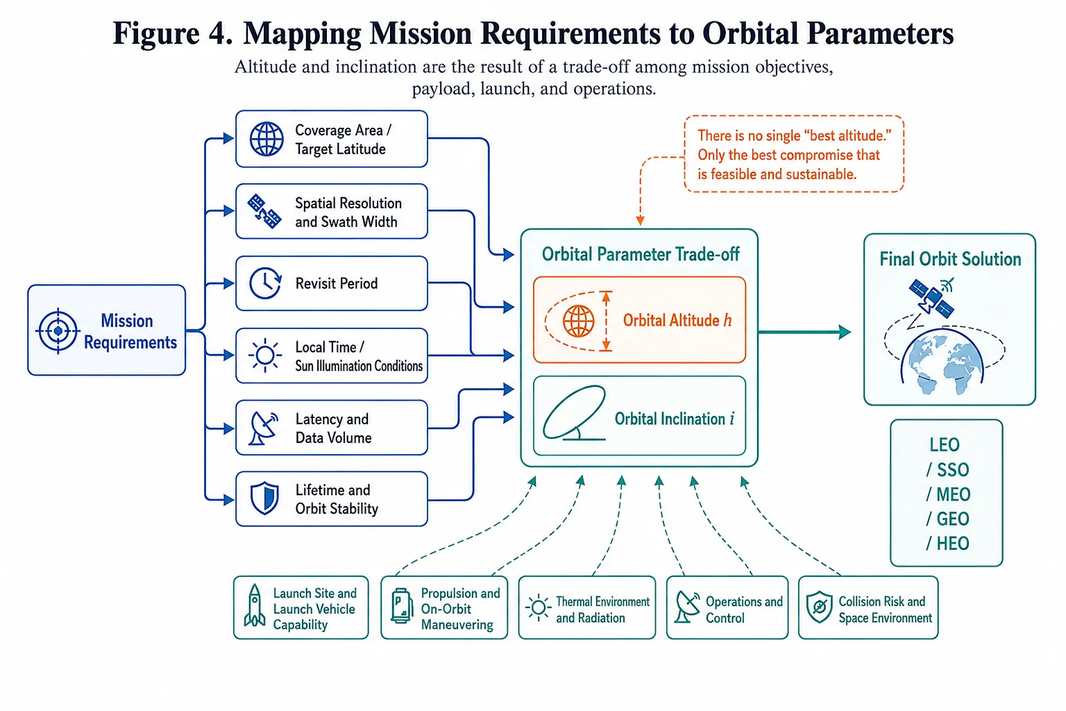
Altitude and inclination are the result of trade-offs among mission requirements, payload performance, launch constraints, and operations. Source: Illustration created by the author.
6. Why Can’t You Locate a Satellite If You Know Its Altitude and Inclination?
Altitude and inclination define only a family of possible orbits.
A complete description of an ideal orbit also requires the semi-major axis, eccentricity, inclination, right ascension of the ascending node, argument of perigee, and the satellite’s position along the orbit. In real-world applications, the epoch, coordinate reference frame, time system, and orbital model must also be specified.
China’s current national standard GB/T 29079-2012, Classification and Common Parameter Symbols for Spacecraft Orbits, standardizes the relevant orbit classifications and notation.[12]
One way to think about it is this: altitude tells you how far the road lies from Earth; inclination tells you which latitudes that road crosses; RAAN tells you which way the entire orbital plane is oriented; and a phase parameter tells you where the satellite is on that road right now.
Without those additional parameters, you may understand roughly how the satellite flies, but you still do not know where it is at a particular moment.
Conclusion
Knowing a satellite’s altitude and inclination already allows us to infer several broad characteristics: whether its mission prioritizes resolution or coverage, whether it primarily serves equatorial, mid-latitude, or global regions, and how factors such as communications latency, single-satellite visibility time, and constellation size may change.
Calculating actual waiting times or the required number of satellites, however, still requires information about orbital planes, phasing, payload field of view, minimum elevation angles, user distribution, and service continuity requirements.
An orbit is not merely a background condition after a satellite reaches space. It is an integral part of mission design. The reason a satellite flies where it does is rarely found in one neat numerical value. It emerges from a system-level trade-off among payload performance, coverage, launch constraints, energy, lifetime, and operations.
Choosing the right orbit is only one part of building a viable satellite mission. As China’s rapidly expanding space manufacturing ecosystem brings greater satellite, payload, and launch capacity to the global market, international customers can increasingly access competitive solutions across satellite manufacturing, payload integration, launch services, and constellation deployment. STARPATH GLOBAL helps international customers connect these capabilities with their specific mission requirements—from early-stage mission planning to customized satellite and launch solutions. Contact STARPATH GLOBAL to discuss your satellite project.
References
[1] European Space Agency, “Types of orbits,” definitions and typical ranges for LEO, polar, sun-synchronous, MEO, GEO, and transfer orbits.
[2] NASA Science, “What Is an Orbit?” and “Catalog of Earth Satellite Orbits,” covering orbital periods, inclination, eccentricity, and common orbit types.
[3] China National Space Administration, explanatory material on artificial Earth satellite orbits, geosynchronous and geostationary orbits, and sun-synchronous orbits.
[4] NASA NTRS, “Introduction to Orbital Mechanics and Spacecraft Attitudes for Thermal Engineers,” covering the velocity change required for orbital plane changes.
[5] European Space Agency, “Launch site” and “Ariane 5: payload and geography open super-efficient path to GEO,” covering launch-site latitude and inclination penalties.
[6] China Manned Space Agency, publicly available orbital parameters for China’s space station.
[7] NASA, “International Space Station” and “Human Spaceflight Factsheet,” covering ISS altitude and its 51.6-degree inclination.
[8] European Space Agency, “Newcomers Earth Observation Guide,” describing a typical sun-synchronous Earth observation orbit of approximately 700 kilometers and 98 degrees.
[9] China Satellite Navigation Office, BeiDou Navigation Satellite System Signal in Space Interface Control Document and BeiDou educational materials, covering nominal GEO, IGSO, and MEO parameters.
[10] European Space Agency, “Galileo Facts and figures,” covering Galileo’s 23,222-kilometer MEO altitude and 56-degree inclination.
[11] NASA Science, “Catalog of Earth Satellite Orbits,” covering the period, eccentricity, and 63.4-degree inclination of Molniya orbits.
[12] National Public Service Platform for Standards Information, GB/T 29079-2012, Classification and Common Parameter Symbols for Spacecraft Orbits, currently in force.