SkyFi, the leading Earth Intelligence Platform, announced an update to its Android Team Awareness Kit (ATAK) plugin. The new release introduces a suite of powerful features designed to give tactical and remote teams unprecedented control over their Areas of Interest (AOIs) and imagery, ensuring mission readiness and security in any environment. The SkyFi ATAK plugin supports tactical coordination, planning, and situational reference for public safety, municipal, disaster response, and defense teams operating on Android-based TAK devices.
“Our objective is to provide warfighters, first responders, emergency managers, and relief organizations with the answers they need when they need them. By seamlessly integrating SkyFi’s Earth Intelligence capabilities into the workflows of our users, this ATAK plugin update is a direct reflection of that commitment,” said Kate van Dam, head of government at SkyFi. “With these more intuitive controls and robust offline capabilities, we are making critical data accessible to teams on the ground so that they can make informed decisions with confidence, no matter the mission or conditions.”
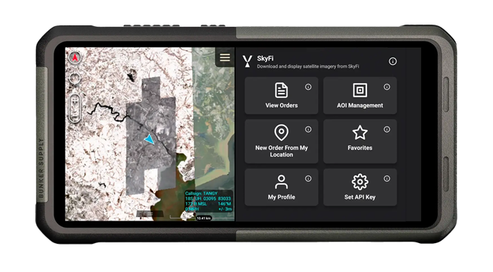
The upgrade further enhances users’ ability to access high-resolution commercial satellite imagery inside the Android Team Awareness Kit (ATAK) environment. Built with GoTAK, the plugin connects SkyFi’s platform to field operations in real time, without the need for a custom server or specialized hardware. Users will now have access to advanced AOI management tools, including the ability to manually draw, name, and save custom polygons. The update also streamlines the process of defining new AOIs by allowing operators to use a pin drop, geographic coordinates, or their current location as a center point. This increased flexibility ensures precision and speed when tasking satellite imagery directly from the field.
Key upgrades also improve imagery management. With the introduction of automatic offline caching, operators can now access critical satellite imagery even in disconnected environments. Additionally, users can better organize and share their data by favoriting, archiving, and sorting images by date, provider, or AOI, ensuring critical intelligence is always at their fingertips.