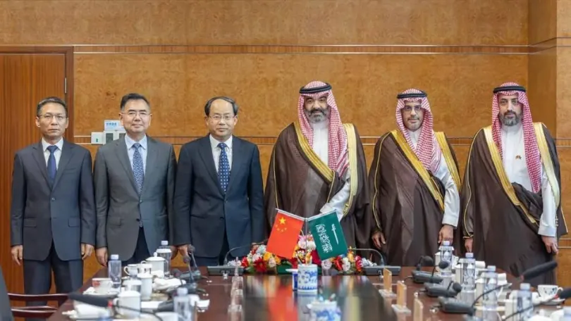
On July 13, 2026, China National Space Administration (CNSA) Administrator Shan Zhongde met in Beijing with Abdullah Alswaha, Saudi Arabia’s Minister of Communications and Information Technology and Chairman of the Board of the Saudi Space Agency. The two sides discussed cooperation across deep space exploration, space debris mitigation, and communications satellites under a bilateral space cooperation agreement, and reached broad consensus. CNSA Chief Engineer Li Guoping and China Aerospace Science and Technology Corporation CFO Chen Lin also attended.
The three areas covered in the meeting — deep space exploration, space debris mitigation, and communications satellites — are commonly used as indicators of a space program’s maturity: the ability to operate at long range, the ability to manage orbital safety, and the ability to deliver applications at scale. These are some of the strongest cards China’s space program currently holds internationally. In recent years, an increasing number of countries across the Middle East, Africa, and Southeast Asia have chosen to cooperate with China on space programs, reflecting the continued build-out of China’s space infrastructure.
Deep Space Exploration: From a Club for Space Powers to “A Single Instrument Counts Too”
Deep space exploration has historically been limited to a small number of space-faring nations, given its technical complexity and capital requirements. That pattern has been shifting in recent years.
China’s Chang’e missions have achieved a landing and sample return on the far side of the Moon, and the Tianwen-1 mission completed orbiting, landing, and roving operations at Mars within a single mission. Building on this, initiatives such as the International Lunar Research Station (ILRS) provide participation pathways for other countries through payload hosting, joint development, and data-sharing arrangements. Saudi Arabia previously contributed a small lunar optical imaging instrument aboard the Chang’e-4 mission, an early example of this cooperation model.
For countries developing their own space capabilities, this incremental participation model lowers the barrier to involvement in deep space programs. A country does not need to first build a complete space industrial base — experience and technical talent can be accumulated mission by mission.
Space Debris: The Messier the Orbit, the Less Reliable Your Data Supply
As satellite numbers increase, so does the risk of orbital collisions. CNSA has maintained a dedicated space debris program for a number of years, covering monitoring and early warning, passivation of retired rocket upper stages, and end-of-life deorbiting of defunct satellites. Earlier this year, CNSA also announced plans to build a ground-and-space monitoring network for near-Earth asteroid defense.
For countries building out their own satellite systems from scratch, “how do we keep our satellites from being hit by debris” is a real operational concern. For organizations that don’t operate satellites themselves but rely on satellite-derived data, the same issue shows up differently: how stable the orbital environment is indirectly determines whether they can keep receiving data reliably and consistently. That’s one reason space debris is discussed alongside deep space exploration and communications satellites in this kind of bilateral space cooperation.
Communications Satellites: From One-Off Missions to a Packaged, End-to-End Service
Cooperation on communications and remote sensing satellites between China and the Middle East actually predates this meeting by close to a decade. China began building the “Belt and Road” Space Information Corridor in 2016, providing communications, navigation, and remote sensing satellite services to countries along the route. On satellite navigation, China and Arab states established cooperation mechanisms early on to support BeiDou adoption in the region. Specific to Saudi Arabia, China launched two remote sensing satellites for the country in 2018, among the earlier outcomes of bilateral space cooperation. This year, China’s low Earth orbit communications constellations have continued to expand through frequent launches.
For countries advancing national strategies such as Saudi Arabia’s Vision 2030, this kind of cooperation has practical value: communications and navigation satellites support infrastructure development, while remote sensing data supports agriculture, energy, and urban planning. What China offers in this space is shifting from one-off mission delivery toward an integrated package covering launch, satellite manufacturing, ground station construction, and technical training.
Launching and deploying a constellation is only one step. Whether local teams can actually put the data to use — and turn that investment into measurable output — is usually the part that takes longer and gets overlooked more easily. That’s also why a number of these cooperation models include technical training for local teams alongside data processing itself, so the buyer isn’t entirely dependent on outside support to keep using the data. National-level infrastructure investment eventually shows up in how much data an enterprise can access: the more complete the ground stations and constellation network, the more — and more consistent — the locally available remote sensing and communications data tends to become.
Getting a Satellite Into Orbit Is Just the Start — the Real Value Is in the Answer the Data Provides
Deep space exploration, debris mitigation, and communications satellite build-out all point to the same underlying fact: the number and variety of satellites observing the ground is increasing. But for organizations that need satellite data for their operations, what actually determines whether the investment pays off is rarely “how many satellites are up there” — it’s whether that data can be turned into something useful for the business.
Optical, SAR (Synthetic Aperture Radar), and thermal infrared satellite imagery don’t, on their own, answer specific questions like “will this parcel of land flood” or “how is this field’s crop doing.” Turning raw imagery into a usable judgment typically requires an additional layer of data processing, industry-specific modeling, and integration with ground-based data.
This is the layer STARPATH GLOBAL works in: integrating multi-source satellite data — optical imagery, SAR, thermal infrared, NDVI vegetation indices, and InSAR ground deformation — with domain expertise and ground-based data to support risk assessment for climate- and ground-condition-sensitive industries such as agriculture, insurance, infrastructure, and energy.
Flooding. Arid regions like Saudi Arabia see infrequent rainfall, but extreme rainfall events do occur. According to research published in an MDPI journal, a 2009 storm in Jeddah delivered roughly 70mm of rain in three hours, contributing to more than 113 reported deaths and damage to over 10,000 homes and businesses; a subsequent 2011 storm caused a dam failure in the same area. According to reporting from Anadolu Agency, red-level rainfall warnings were issued for Mecca, Medina, and other cities in January 2025, with several cities experiencing significant flooding. When cloud cover limits optical satellite imagery — common during severe convective weather — SAR imagery can continue capturing surface conditions regardless of cloud cover or time of day. This is one reason SAR has become a standard tool for flood monitoring: with or without clouds, it can still show the extent of flooding on the ground.
For insurers and municipal emergency departments, this changes how damage assessment can work. Loss assessment after a flood has traditionally relied on manual field surveys — slow to mobilize, prone to disputes, and time-consuming. Using SAR imagery to delineate the affected area and quantify damage can upgrade the process from “sending people out to look” to “assessing from the image,” improving both the speed and consistency of claims response. For regions where severe weather events are infrequent but high-impact when they do occur, this is a real efficiency gain in claims and emergency response.
Heat monitoring. According to research published in a Nature-affiliated journal, temperatures during the June 2024 Hajj period in Mecca reached approximately 51.8°C, and more than 1,300 pilgrims were reported to have died from heat-related causes — one of the more significant extreme heat events recorded in the region in recent years. Events like this have also made regional-scale heat monitoring a more prominent public safety concern.
Thermal infrared satellite data supports this kind of monitoring by measuring land surface temperature to identify urban heat island effects and localized thermal anomalies. For municipal authorities and large event organizers, this data can help identify areas of concentrated heat risk ahead of time, supporting resource allocation and contingency planning rather than only post-event assessment. For insurers and infrastructure planners, surface temperature data is also one input worth considering for long-term site selection and risk evaluation.
Water resources and agriculture. According to Arab News, Saudi Arabia has limited surface water and depends heavily on groundwater for agriculture. Decades of groundwater extraction have led to observable depletion of local aquifers. Against that backdrop, figuring out which agricultural areas face water stress, and how severe any resulting yield loss might be, is a practical question every growing season.
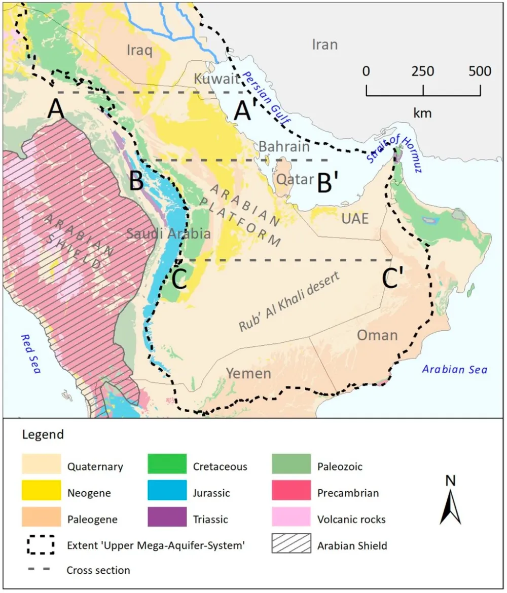
Simplified geological map of the Arabian Peninsula showing the extent and outcrop of the principal aquifers of the Upper Mega Aquifer System in Saudi Arabia, considered as one of the largest aquifer systems in the world. Due to good water quality and high yield, these aquifers have been intensively exploited.(Infographic courtesy of the Hydrogeology Journal)
Satellite remote sensing can help make that determination earlier. Hyperspectral satellite data can pick up more detail than standard optical imagery. Standard optical imagery is essentially a photograph — it shows how green or dense a crop looks. Hyperspectral imagery is more like giving the crop a thorough checkup: it can detect changes invisible to the naked eye. When a crop is under water stress or disease pressure, the spectral signal shifts first — by the time leaves visibly yellow or wilt, the window for early intervention has often already passed. This means risk management doesn’t have to stay limited to tallying losses after the fact — it can shift toward acting before damage sets in. Combined with continuously tracked NDVI vegetation indices, this type of data can be used to identify underperforming areas within a field to guide targeted irrigation and fertilization, and to delineate affected areas and shorten claims timelines for agricultural insurance after a drought or flood event. This approach has already been applied in yield-estimation trials and agricultural insurance claims work in China.
From Government-to-Government Cooperation to the Last Mile of Industrial Application
Space cooperation at the government level builds the infrastructure and policy framework. For organizations doing business in construction, agriculture, energy, or insurance in countries partnering with China on space programs, figuring out how to turn a growing supply of satellite data into usable risk assessments will remain a recurring challenge over the next several years. That still requires another layer — data processing, analytical modeling, and use-case adaptation — which is where geospatial and satellite data analytics providers like STARPATH GLOBAL come in.
Regardless of how many satellites are in orbit or how far communications and remote sensing networks expand, the question we’re solving stays the same: how to turn satellite data into intelligence that energy, mining, agriculture, maritime, and infrastructure operations can put to direct use.
If your organization is evaluating how satellite data could support disaster monitoring, agricultural and insurance risk assessment, or infrastructure and energy monitoring, we’d welcome the chance to talk through your specific use case and help you figure out which data types and analytical approaches would create real value for your business. Talk to our experts →