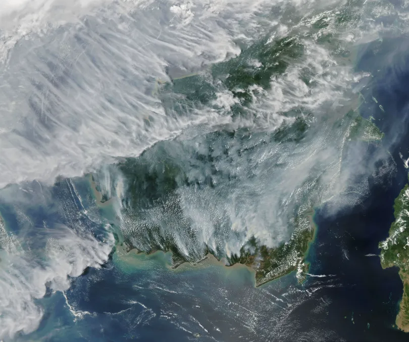
Southern Southeast Asia has entered its traditional dry season. As hotter and drier conditions develop, fire and smoke signals are emerging in parts of Indonesia and the wider region, raising concerns about the risk of transboundary haze later in the season.
As of July 26, 2026, Palangka Raya, the capital of Central Kalimantan, Indonesia, had recorded 109 forest and land fire incidents, affecting a total of 54.44 hectares. Local education authorities subsequently instructed schools to adjust learning activities in response to deteriorating air-quality conditions and reduce students’ exposure to haze.
Similar warning signs are emerging in Sumatra. Preliminary multi-agency satellite analysis published by the Riau provincial government indicates that 15,477.9 hectares of forest and land burned during the first half of 2026, compared with 907.8 hectares in the first half of 2025—roughly 17 times the previous year’s level.
Pantau Gambut reported 23,546 hotspots detected by satellites within Indonesia’s peatland hydrological units during January–March 2026. Its published chart also included monthly observations dating back to October 2025. Riau and West Kalimantan recorded the highest totals. Not every hotspot represents a confirmed fire. However, when clusters of thermal anomalies coincide with low rainfall, falling peat moisture, and areas with a history of fire, they become warning signals that should not be ignored.
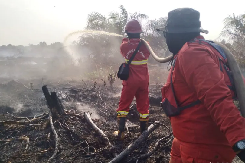
The Manggala Agni team struggles to extinguish a peatland fire in Riau Province. (Photo/Media Center Provinsi Riau)
The most dangerous part of the season may not have begun yet.
In its *Haze Outlook 2026*, the Singapore Institute of International Affairs (SIIA) assigned a “Red” rating—the highest risk level—to the possibility of a severe transboundary haze event during the remainder of the year. This is only the second Red rating since the outlook was launched in 2019, following the previous Red assessment in 2023. The report identifies August and September as the period when fire and haze risks may be most acute.
As of July 20, 2026, the ASEAN Specialised Meteorological Centre assessed that El Niño conditions were already present and likely to strengthen during the second half of the year. The Indian Ocean Dipole remained neutral in June, but models projected a possible transition to a positive phase around August–September. Together, these conditions could increase the likelihood of hotter and drier weather in southern Southeast Asia.
The real concern is not the label attached to a weather event. It is the convergence of conditions already taking shape: lower rainfall, continued peatland drying, increasing hotspot activity, and seasonal winds capable of carrying smoke toward densely populated and industrial areas.
For companies with assets, supply chains, or investments in Southeast Asia, the question is no longer simply whether haze will occur this year.
If the risk escalates, the difference between early warning and reading about it in the news is a matter of weeks. See how satellite monitoring closes that gap →
Why Peatland Fires Are So Difficult to Prevent
Most people picture a fire as visible flames moving across the ground. Peatland fires behave very differently.
Southeast Asia’s peatlands are wetland ecosystems formed over thousands of years from accumulated, partially decomposed plant material. In their natural state, peat soils retain high levels of water, making them difficult to ignite while allowing them to store vast quantities of organic carbon.
Drainage, land conversion, and prolonged dry weather can lower the peatland water table. As water is lost, peat oxidizes, dries, and subsides. A naturally wet ecosystem can gradually become a continuous layer of combustible organic material—turning from a fire-resistant barrier into an underground fuel reserve.
Agricultural burning, land clearing, or another ignition source can then set fire to the peat below the surface, causing smouldering combustion.
Unlike open flames, peat smouldering may produce little visible fire while spreading slowly through dry subsurface layers for weeks or even months. An area that appears extinguished at the surface can ignite again because residual heat remains underground. Where water access is limited, complete suppression becomes especially difficult.
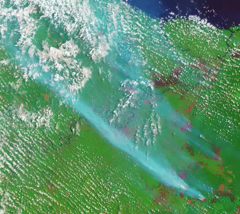
September 2015: A false-color Landsat 8 image shows fire hotspots (orange) and smoke (blue) over Jambi Province, Sumatra. Image: NASA Earth Observatory (Joshua Stevens, using USGS Landsat data)
This is why field patrols alone can miss the early stages. By the time a team sees smoke, a surface thermal anomaly, or signs of reignition, the fire may already have been burning below ground for some time.
Satellites also have limitations:
- Optical satellites can identify smoke plumes, burn scars, and surface changes, but clouds and dense smoke can obscure the view.
- Thermal infrared satellites can detect some surface heat anomalies, but may miss subsurface smouldering that has not yet produced a strong surface signal.
- Synthetic aperture radar (SAR) operates independently of daylight and can observe surface structure and moisture-related changes through clouds and most smoke. However, it cannot penetrate peat layers to directly locate an underground fire front.
Peatland early warning should therefore not be framed as “seeing every underground fire from space.” Its purpose is to identify high-risk conditions earlier:
- Rising flammability: Which peatland areas are continuing to dry?
- Emerging anomalies: Where are thermal anomalies, smoke plumes, or vegetation changes repeatedly appearing?
- Escalation potential: Which initial fire signals could spread rapidly because of wind, poor access, or limited nearby water?
Satellites cannot prevent human ignition. They can, however, narrow a vast area of possible risk into a small number of locations that require immediate attention.
Multiple hotspots, limited field teams, and no way to know which one is turning into a real fire. Get help prioritizing what to check first →
How a Local Fire Becomes a Transboundary Haze Event
A single fire covering only a few hectares will not normally create transboundary haze on its own. The greater danger arises when numerous fires continue burning across dry peatlands, or when a large fire complex releases smoke over an extended period under winds favorable for long-range transport.
Persistent peat smouldering can generate smoke that travels hundreds of kilometers—and under favorable atmospheric conditions, farther across national borders—turning localized fire activity into a regional air-pollution event.
The progression typically looks like this:
Peatland loses moisture and ignites
→ Subsurface smouldering continuously releases smoke and fine particulate matter
→ Multiple fires or a larger fire complex generate a persistent smoke plume
→ Wind direction, wind speed, and atmospheric conditions transport the plume over long distances
→ Air quality deteriorates in downwind cities and neighboring countries
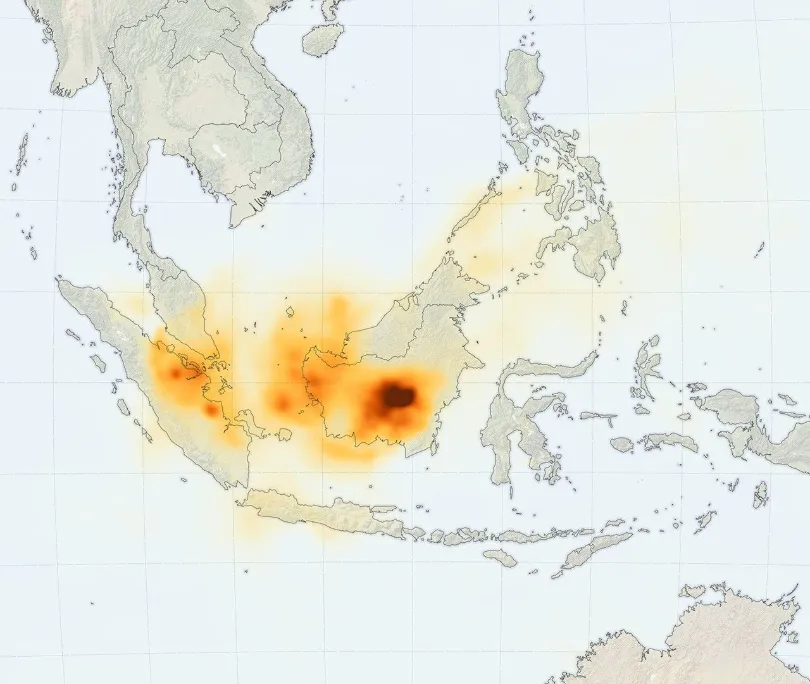
NASA GEOS-FP model simulation of organic carbon plume dispersal, September 17, 2019. Image: NASA Global Modeling and Assimilation Office
This is why the ASEAN Specialised Meteorological Centre (ASMC) does not assess haze risk based on hotspot counts alone. Its analysis also considers rainfall, wind conditions, hotspot locations, fire persistence, and the distribution of smoke observed by satellites.
The distinction matters: a hotspot is a risk indicator, not a final determination of fire size or smoke origin.
Once haze begins to spread, the effects can cascade across the region: declining air quality and greater respiratory-health risks; school closures and cancelled outdoor activities; reduced visibility at airports, ports, and on roads; disruption to construction, agriculture, and infrastructure operations; losses across plantation, insurance, logistics, and tourism sectors; and the release of carbon that had previously remained stored underground.
The severe haze years of 1997 and 2015 demonstrated how quickly these impacts can reach regional scale. History is useful only if we act on its warnings. The signals now accumulating across Southeast Asia deserve attention before the same pattern is allowed to repeat.
The cost of a peatland fire is therefore rarely confined to the land that burns.
Public Health Costs
Peat-fire smoke contains high concentrations of PM2.5 and other air pollutants. A modeling study involving researchers from Harvard University and Columbia University estimated that haze from the 2015 fires may have caused approximately 100,300 excess premature deaths across Indonesia, Malaysia, and Singapore.
This was a model-based estimate, not a registered death toll. Even so, it demonstrates the potentially severe health burden of prolonged smoke exposure.
Regional Operational Disruption
Haze-related visibility loss can affect aviation, roads, ports, schools, and outdoor work. For businesses, the resulting costs may include supply-chain delays, employee health protection, constrained field inspections, and project shutdowns—often far beyond the fire site itself.
Compliance and Reputational Exposure
When satellite imagery is analyzed together with land ownership, concession boundaries, and historical hotspot records, the relationship between a fire and a specific operating area may come under scrutiny from regulators, customers, investors, and the public.
A fire in a remote peatland can therefore evolve within weeks from an environmental incident into a public-health crisis, an operational disruption, and a reputational risk.
The World Bank estimated that Indonesia’s 2015 forest and peatland fires caused at least US$16.1 billion in economic losses, equivalent to approximately 1.9% of the country’s GDP that year. For companies, this type of exposure can no longer be treated as a standalone environmental issue. It is simultaneously a business-continuity, supply-chain, health and safety, and reputational risk.
The financial exposure may spread much faster than the fire itself.
A single fire season cost Indonesia 1.9% of its GDP. What would a comparable event cost your operations? See how satellite monitoring reduces this exposure →
More Than Burned Land: The Green-Economy Case for Peatland Fire Prevention
Peatland fires affect more than air quality and land safety. They release carbon stored in peat soils, creating additional pressure on regional climate commitments, carbon-management programs, and emerging carbon markets.
Peat soils contain vast stores of organic carbon. Once fire enters the subsurface layer, carbon accumulated over long periods is released primarily as carbon dioxide, alongside methane, fine particulate matter, and other pollutants.
Peatland fire prevention therefore sits at the intersection of disaster management, ecosystem restoration, and climate action.
Several Southeast Asian countries have announced net-zero or low-carbon development targets. In this context, continuous records of peatland condition, fire extent, and restoration performance will have increasing policy and commercial value.
Satellite and geospatial intelligence can help organizations:
- Establish pre-fire land-cover and ecological baselines;
- Map burn scars and affected areas;
- Identify possible reignition and subsequent changes;
- Monitor rewetting, canal blocking, and vegetation recovery;
- Create traceable spatial records for regulatory reporting, ESG disclosure, and carbon management.
Remote-sensing results, however, do not automatically constitute verified emissions reductions.
Satellite-derived burn area, vegetation change, and surface-moisture indicators can provide important inputs for carbon accounting. Formal carbon-credit issuance or emissions-reduction verification still requires an applicable methodology, field measurements, and independent validation.
The most immediate value of satellite monitoring is the creation of continuous, reviewable spatial evidence: What was the condition of the site before the fire? How much land was affected? What changed after restoration measures were implemented?
The same intelligence can support both immediate fire response and longer-term ecosystem recovery assessment, environmental compliance, and disclosure.
Need to track ecosystem recovery and carbon-sink performance over time? Explore satellite environmental monitoring solutions →
The Problem Is Not a Lack of Data
Many organizations operating in Southeast Asia already have some monitoring capabilities.
Peatland maps, watchtowers, field patrols, meteorological data, and local sensor networks may already be in place. The real problem is that these inputs often remain fragmented across different departments and systems, preventing teams from forming a unified risk picture before a fire expands.
Each source has strengths and limitations:
- Field patrols confirm conditions on the ground but cover limited areas.
- High-frequency hotspot products update quickly but may not accurately define the affected land parcel.
- Optical satellites provide intuitive visual evidence but can be obstructed by cloud and haze.
- SAR imagery supplements surface observations under cloudy conditions but cannot directly detect underground fire.
- Water-level wells and ground sensors provide precise local measurements but represent only a limited number of locations.
The answer is not to replace every existing tool with a single technology. It is to connect fragmented observations through a persistent space-based layer:
- Use hotspot, rainfall, and weather data to screen daily risk;
- Cross-check surface changes and affected areas with optical and SAR imagery;
- Analyze anomalies against peatland boundaries, historical fires, roads, water sources, concessions, and critical assets;
- Send satellite detections to field teams for verification and feed the results back into the monitoring workflow;
- Route high-priority alerts directly to the responsible decision-makers.
One technical boundary must remain clear: satellites cannot directly and precisely measure the peat water table at a specific location.
Satellite data can use changes in surface moisture, temperature, vegetation, and surface water to identify areas that may be undergoing persistent drying. Actual groundwater depth still requires calibration with monitoring wells or field sensors. Combining the two provides both broad regional coverage and local measurement confidence.
The greater objective is to establish a complete operating chain—from risk assessment and early detection to emergency response and post-event review.
Satellite monitoring is often reduced to a single question: “How much earlier can we receive an alert?” For organizations that operate in high-risk areas over the long term, the more valuable asset is a continuously accumulated and traceable observation record.
A time series showing how each event emerged, spread, was contained, and recovered can support internal risk reviews. It can also provide objective evidence for regulatory reporting, ESG disclosure, insurance claims, and stakeholder communication.
In other words, the system is designed not only to help organizations know earlier, but also to respond faster and demonstrate clearly what happened.
Applied to peatland fire management, this capability can support:
- Early warning: Routinely monitor hotspots and surface anomalies in high-risk areas, using risk thresholds to flag locations before smouldering develops into widespread surface fire or reignition.
- Rapid response: Once an anomaly is confirmed, deliver fire location and potential spread information to field teams, reducing the time between detection and on-site action.
- Source and concession-overlap analysis: Compare fire locations with peat degradation, drainage history, land ownership, and concession boundaries to identify possible parcel-level associations for further verification.
- Regional impact assessment: Combine wind conditions with smoke-dispersion modeling to support air-quality warnings and anticipate operational disruption.
- Compliance and disclosure support: Create objective, traceable, and reproducible imagery records for regulatory submissions, insurance assessment, and ESG reporting.
A useful alert should provide more than coordinates. It should answer:
- Is the anomaly recurring or persistent?
- Is it located within peatland or a historical fire-risk area?
- Which communities, plantations, facilities, or other critical assets are nearby?
- Could current winds carry smoke toward a populated area?
- How quickly should a field team arrive?
- Should the area remain under observation for possible reignition?
If these questions cannot be answered quickly, a technically correct hotspot detection may still fail operationally. The coordinates may be accurate, but the response may arrive too late, go to the wrong team, or overlook the asset most exposed to fire and smoke.
Detection without prioritization is information. Detection connected to action is early warning.
Only when monitoring forms a closed operational loop—detect, assess, notify, verify, respond, and review—does satellite data become decision-grade intelligence.
Most monitoring setups stop at detection. The gap between a hotspot and a decision is where damage compounds.
How can satellite alerts be integrated into your existing patrol or emergency-response workflow? Get a customized solution →
How STARPATH GLOBAL Supports Peatland Fire-Risk Monitoring
For peatland managers, the most valuable warning is not always “a major fire has started here.” It may be:
- A priority area is continuing to dry;
- Thermal anomalies are repeatedly appearing near a road or drainage canal;
- Vegetation condition and surface-moisture indicators are changing at the same time;
- An anomaly has reappeared after a fire was treated;
- A rewetting or ecosystem-restoration measure is not producing the expected result.
Satellites provide the coverage and revisit frequency required to identify these patterns. Ground monitoring helps determine what the signals mean in the field. A clear response workflow turns the intelligence into action.
The real challenge is not simply whether a fire can be seen from space. It is whether data from different sources can be converted—while there is still time to reduce losses—into a timely, clear, and executable decision: where to go, what to inspect, and who should act.
STARPATH GLOBAL provides satellite data acquisition, sensor selection, geospatial analytics, and Forward Deployed Engineer (FDE) services. Based on the target area and management objectives, we help clients design an operational workflow spanning risk baselines, routine monitoring, anomaly alerts, field feedback, and post-fire assessment.
Through the STARPATH GLOBAL Pioneer Partner Program, selected organizations can receive a complimentary opportunity assessment and value-validation process. STARPATH GLOBAL covers the cost of opportunity discovery, solution design, qualified on-site engineering support, and ROI validation for selected Pioneer Partners. No formal procurement commitment is required until the expected business value has been demonstrated.
Do not wait for a fire to make headlines before finding out how exposed you already are. Apply to become a STARPATH GLOBAL Pioneer Partner →