In July 2026, UN News reported that UNEP’s Methane Alert and Response System had issued more than 5,000 alerts concerning major methane emission events across 33 countries. UNEP separately reported that, as of April 2026, IMEO had documented more than 40 mitigation cases. At the time, approximately 13% of MARS alerts had received a recorded response, meaning that the event was investigated and relevant information was reported back to UNEP.
Here, a “response” does not necessarily mean that a repair has been completed. Under UNEP’s reporting methodology, recipients must provide information about the corresponding emissions event—such as investigation findings, the cause of the emissions, or mitigation measures—for the case to be recorded as having received a response. Therefore, the 13% response rate should not be interpreted to mean that all of the remaining 87% of emissions went unaddressed: some organizations may have investigated or taken action without reporting back to MARS.
Nevertheless, the fact that nearly 90% of alerts received no formal response still reveals a clear gap: having observational data is not the same as having the capacity to use it. As satellites gradually reduce monitoring blind spots for major methane emissions, the governance challenge is shifting from whether emissions can be detected to who receives, investigates, and acts on alerts—and how the results of those actions are verified. Satellites can provide leads, but they cannot complete the entire process from detection to repair on their own.
Detecting Emissions Is Only the Beginning—Verifying Action Is Where the Value Lies
Methane is colorless, and many emissions may occur in remote oilfields, storage and transportation facilities, or along pipeline corridors. When a valve, compressor, storage tank, or pipeline section malfunctions, emissions may continue for hours, days, or even longer without being immediately detected by personnel.
Traditional methane management in the oil and gas industry relies primarily on field inspections, fixed sensors, aircraft or drone surveys, and annual inventories based on equipment counts and emission factors. These methods remain indispensable, but they differ in their geographic coverage and temporal resolution.
Fixed sensors can continuously monitor locations where equipment has already been installed. Aircraft and drones can provide more detailed regional or facility-level inspections. Annual emissions inventories are suitable for high-level accounting but are often unable to capture a specific high-emission event in a timely manner.
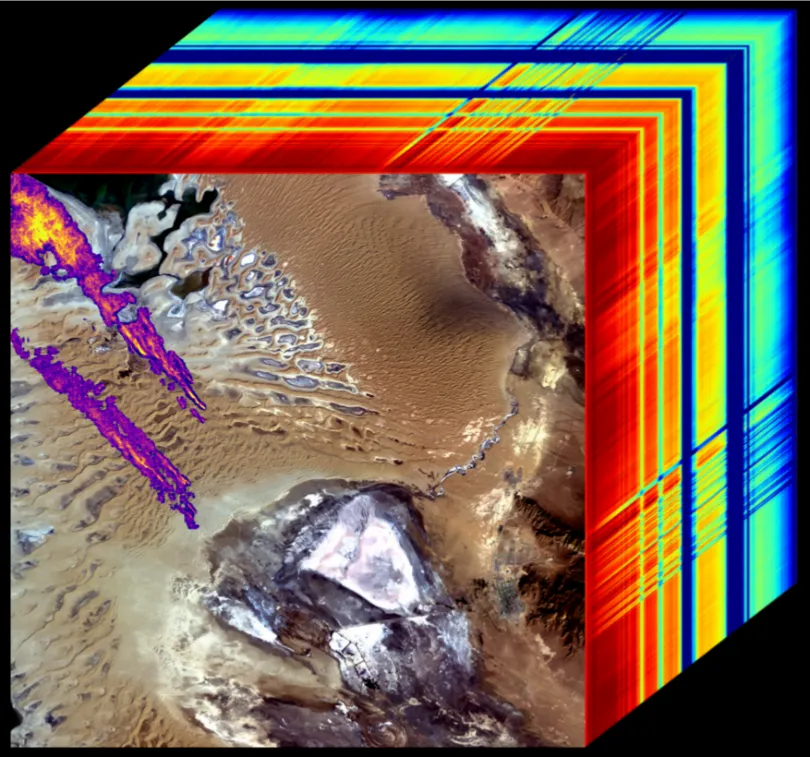
Satellites provide an additional layer of wide-area screening. Although methane is invisible to the human eye, it absorbs solar radiation in specific shortwave infrared wavelengths. Imaging spectrometers can use this spectral signature to identify areas of enhanced methane concentration against the background.
When emissions are sufficiently large, weather and surface reflectance conditions are suitable, and the wind field produces an identifiable plume, analysts can combine plume shape, wind speed, and wind direction to estimate the location and emission rate of the source. The anomalous location can also be matched with data on wells, pipelines, compressor stations, storage tanks, and other facilities, providing governments or operators with leads for arranging field investigations.
Different satellites perform different functions within this monitoring chain. Regional-scale instruments are suited to identifying large-area concentration anomalies, while high-spatial-resolution instruments can help narrow an anomaly down to a specific facility, well area, or nearby pipeline. MARS combines data from multiple satellite instruments and analytical methods rather than relying on a single satellite to perform every task. Explore an overview of satellite applications →
However, this capability has clear limitations. Satellites cannot reliably detect and quantify emissions under all conditions. Results may be affected by emission magnitude, cloud cover, wind fields, surface reflectance, aerosols, sensor performance, and satellite revisit intervals.
An end-to-end simulation study published in Remote Sensing in 2025 found that, within the matched-filter point-source retrieval framework evaluated by the study, spectral noise, aerosols, surface reflectance, and sensor parameters could all significantly affect retrieval results. For example, when a methane source and its plume are located over a highly reflective surface while the background area has lower reflectance, the resulting reflectance contrast can cause retrieval accuracy to deteriorate rapidly. Under some near-surface aerosol scenarios, aerosol absorption and scattering may also weaken the methane spectral signal and lead to underestimated emission rates.
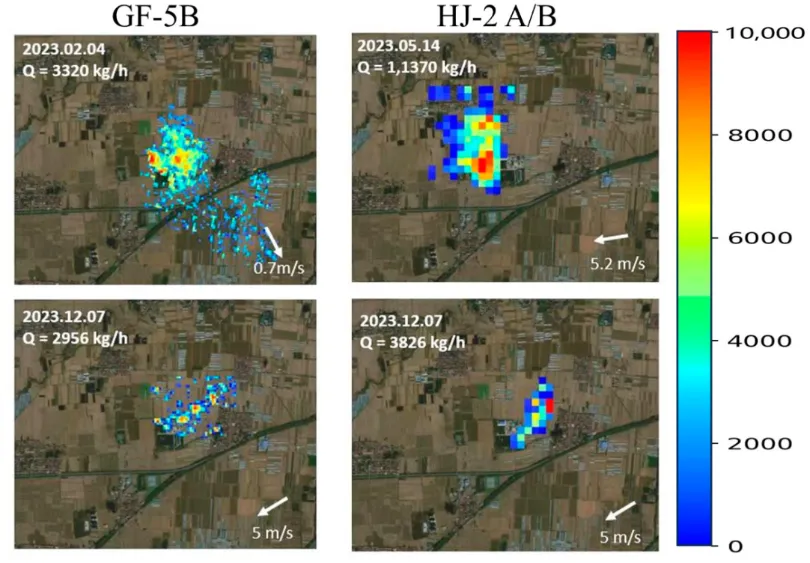
Real retrieval results from different satellites.
Satellite observations must therefore be used within their evidentiary limits:
- Detecting a plume does not necessarily identify the specific malfunctioning piece of equipment immediately.
- The absence of a detected plume during one satellite overpass does not mean that emissions were absent at other times.
- Leaks below the applicable detection threshold may not be detected.
- Estimated source locations and emission rates carry uncertainty.
- When subsequent imagery no longer detects a plume, the finding should, wherever possible, be cross-checked against field measurements, equipment repair records, and observations from other dates.
Satellites are better suited to wide-area screening, the detection of major events, and follow-up verification than to replacing fixed sensors, field inspections, or equipment-level testing.
On this basis, a relatively complete governance process typically includes:
- Satellites or other remote-sensing instruments acquire observational data.
- Analysts or algorithms identify suspected methane plumes.
- The plume location, emission rate, and associated uncertainty are estimated.
- Wind-field data, facility information, and historical imagery are used to assess the likely source.
- Following technical review, an alert is sent to government focal points and relevant operators.
- Governments or operators conduct field investigations and take mitigation measures.
- Subsequent remote sensing, field measurements, and operational records are used to assess whether emissions have stopped or declined significantly.
Within this chain, a satellite initially provides a lead with potentially high investigative value. Identifying the specific equipment involved, determining the cause of the malfunction, and establishing legal responsibility still require facility data, field measurements, and operational records.
A governance loop does not mean that satellites directly assign responsibility. It means that a major emissions event has a traceable time, location, notified recipient, investigation status, mitigation record, and follow-up result. Assess whether satellite monitoring is suitable for your use case →
Algeria: Bringing a Long-Running Emission into the Mitigation Process
The Algeria case, revisited by UN News in July 2026, illustrates how satellites can bring a long-running emission into the mitigation process.
At the Hassi Messaoud oilfield in eastern Algeria, satellites had long recorded continuous methane emissions from a gas-disposal facility associated with an oil well.
A detailed UNEP report shows that Landsat 5 imagery had already recorded signs of emissions at the site in 1999. From 2013 onward, higher-quality satellite observations repeatedly showed methane plumes. According to UNEP, the emissions appeared in nearly every observation that met the applicable quality requirements.
The International Methane Emissions Observatory (IMEO) subsequently provided its analysis to the Algerian government and the national oil company and engaged with the relevant parties. In October 2024, satellite imagery showed no plume at the site for the first time.
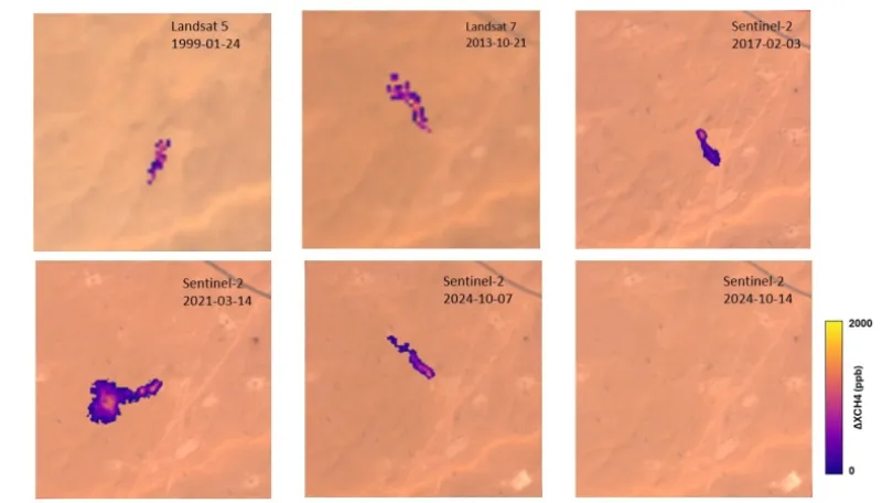
Methane flares in southern Algeria recorded by the Sentinel-2 and Landsat-7 satellites. Credit: IMEO
UNEP estimated that the avoided annual methane emissions would have a near-term climate impact comparable to the annual emissions of approximately 500,000 passenger vehicles.
Without repeated, cross-regional observation, a long-running emission at a remote facility might never rise high enough on regulatory and maintenance priority lists. The significance of this case lies not only in the scale of the emissions, but also in the way satellite monitoring transformed a persistent emission into a specific event that could be located, reported, and located, reported, and tracked through repeated observations.
Argentina: Addressing Gaps in Local Monitoring Capacity
The case of Chubut Province in Argentina further demonstrates how satellites can help address limitations in local monitoring capacity.
In November 2024, Chubut’s environmental and sustainable development authority received a methane alert from MARS. The notification included the coordinates of the emissions, the potential operator involved, and an estimated methane emission rate of approximately 4.2 tonnes per hour.
At the time, Chubut Province lacked its own methane measurement tools. After receiving the alert, the local government forwarded the information to the potential operator. The company then conducted a field investigation and traced the emissions to an oil well.
The finding surprised local officials because the relevant geological formation had not previously been considered a typical gas-bearing reservoir. This shows that satellites can not only help identify emission anomalies near known facilities but may also reveal issues that are not fully covered by existing geological or asset knowledge. The company subsequently installed new equipment to recover the excess gas and prevent similar leaks from recurring.
On 8 January 2025, IMEO reported that subsequent satellite imagery no longer detected the previous emissions at the site, providing independent observational evidence consistent with the reported mitigation. According to UNEP, during the period in which IMEO observed the leak, its near-term climate impact was equivalent to the annual emissions of approximately 25,000 cars.
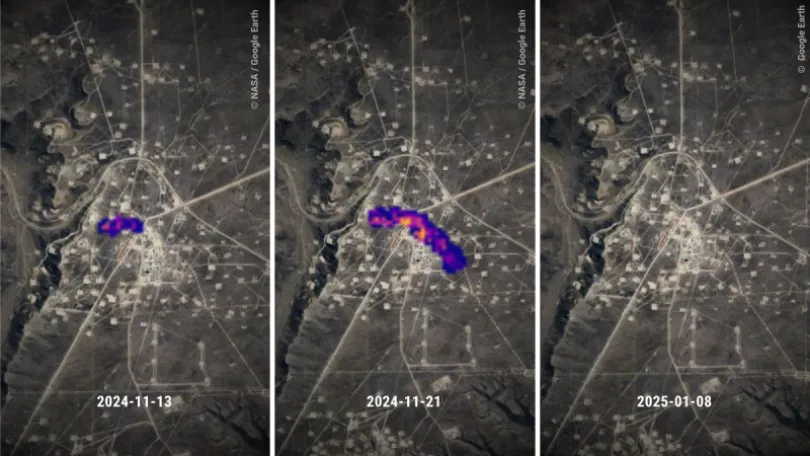
A series of three satellite images show methane detected from oil and gas operations in Argentina and cessation of the emissions following an alert form UNEP. Credit: NASA / Google Earth
For local governments with limited methane-monitoring resources, satellites lower the barrier to obtaining actionable leads on major emissions. Local authorities do not need to deploy fixed sensors at every oil and gas facility before they can require operators to investigate. Satellites do not, however, replace field verification: they provide an entry point for investigation, while asset operators and relevant technical teams must still identify the specific equipment, determine the cause, and take corrective action. See how satellite data can support your operations →
Kazakhstan: From Alert to Repair and Follow-Up Verification
The Kazakhstan case further demonstrates how satellite monitoring can be incorporated into field repair and follow-up verification processes.
MARS detected a large methane plume at an oilfield near the Caspian Sea, with an estimated emission rate of approximately 6.9 tonnes per hour. Because the relevant operator was a member of the Oil and Gas Methane Partnership 2.0 (OGMP 2.0), IMEO could notify the company directly in addition to notifying the government focal point, helping reduce the time required to relay the information.
The operator subsequently conducted a field investigation, traced the leak to a worn section of pipeline, and replaced the affected section.
The repair itself was not the end of the governance process. On 7 April 2025, subsequent satellite imagery no longer detected the previous methane plume, and UNEP concluded that the pipeline replacement had achieved the intended result.
Compared with the two previous cases, the value of the Kazakhstan case lies in the way it connected several critical stages: alert delivery, field investigation, equipment repair, and follow-up verification. It also shows that when government communication mechanisms, asset operators, and field response processes are relatively well defined, satellite data can more readily be converted from an environmental alert into concrete field action.
For corporate management, this type of loop can connect methane monitoring with maintenance work orders, equipment records, and environmental performance documentation. For government authorities and regulators, follow-up satellite observations can also provide supplementary verification independent of the operator’s internal reporting.
The change brought by satellites is not limited to the addition of another monitoring tool. It may also help expand oil and gas methane management from an approach centered on annual accounting to one that continuously tracks specific anomalous events.
From Annual Emissions Inventories to Continuous Anomaly Management
Traditional annual emissions inventories and satellite alerts answer two different types of questions.
Annual inventories are primarily used to estimate how much methane a company or category of facility emits over a given period. They are suitable for high-level accounting, corporate disclosure, and policy evaluation. Satellite alerts, by contrast, seek to identify major emissions anomalies occurring at a specific time and location, helping governments and companies determine whether an event should receive priority investigation.
The two approaches are not substitutes for one another. Annual inventories provide a long-term baseline, while satellites, fixed sensors, aircraft, drones, and field measurements help identify specific events that deviate from that baseline. This allows companies to establish a continuous anomaly-management mechanism in addition to annual accounting.
This is particularly important for the oil and gas industry. Studies across multiple oil and gas-producing regions have found that methane emissions are often highly unevenly distributed, with a small number of high-emitting facilities or events potentially accounting for a substantial share of total emissions. A single equipment malfunction, abnormal venting event, or worn pipeline may generate emissions far above normal operating levels within a relatively short period.
If companies can detect these events earlier, the value extends beyond emissions reduction. Leaked methane is also natural gas that has not been used or sold. Shortening the duration of a leak can help reduce losses of natural gas products. If an alert promptly triggers field investigation and mitigation, it may also reduce related equipment and safety risks.
The primary value of satellites is therefore not to replace existing methane inventories or field inspections, but to add a layer of wide-area screening: identifying high-emission anomalies that may require immediate action and helping prioritize field resources. Book an application value assessment →
Integrating Satellite Monitoring into Investigation and Mitigation Processes
Detecting an anomaly is only the starting point of event management. Whether satellite monitoring creates practical value depends on whether the observations can enter an organization’s existing assessment, investigation, mitigation, and follow-up systems.
Satellite data may first reach government authorities or an organization’s environmental, climate, and sustainability teams. Facility inspection and repair, however, are generally handled by asset operators and their production, operations, and engineering teams. Without clear mechanisms for receiving, transferring, and responding to information, a satellite-detected anomaly may remain confined to an email, map, or environmental report, while subsequent observations remain disconnected from the results of field action.
For relevant organizations, the key is to connect satellite-monitoring results with facility records, asset information, risk classification, and task-management systems. Initial observations identify and locate anomalies requiring investigation. Government authorities or asset operators then organize field verification, while technical and operational teams identify the specific emissions source and take action. Subsequent remote sensing, field measurements, and mitigation records are then used together to evaluate the outcome.
This mechanism can generate value at three stages:
- Detection: Screen for high-emission anomalies across geographically dispersed assets or regulatory jurisdictions.
- Response: Convert monitoring results into field investigations, regulatory follow-up, or maintenance tasks.
- Verification: Combine subsequent remote sensing, field measurements, and mitigation records to evaluate results.
Potential benefits include improving inspection and regulatory efficiency, optimizing the allocation of field resources, reducing natural gas product losses, lowering equipment risks, and providing supplementary data for environmental disclosure, policy implementation, and regulatory verification.
Satellite observations can provide measured information that is independent of any single organization’s internal reporting system. However, they generally cannot, on their own, establish legal responsibility or determine regulatory compliance. Any such conclusion must also consider field measurements, facility information, operational records, and applicable regulations.
Closing the Response Loop Through STARPATH GLOBAL FDE Services
The growing availability of methane observations raises a practical question for governments and operators: how can an external signal be translated into the right internal decision?The answer will vary by organization.Integrating satellite monitoring into investigation and mitigation processes generally requires more than purchasing imagery or connecting to a data interface. Different organizations have different management jurisdictions, asset distributions, facility records, monitoring capabilities, and mitigation mechanisms. The stages at which remote-sensing data can be most effectively applied will therefore also vary.
STARPATH GLOBAL’s FDE Services help organizations apply satellite monitoring data to their own assets and operations. Through the Pioneer Partner Program, qualifying organizations can receive opportunity assessment, solution design, on-site engineering support, pilot validation, and ROI assessment at no cost. FDE engineers work with business, environmental, and technical teams to connect remote-sensing results with asset information and operational workflows, helping turn satellite observations into investigation, response, and follow-up actions. No formal procurement is required until the potential business value has been validated. Explore STARPATH GLOBAL FDE Services →