In the era of AI in space, customers are not simply purchasing an image. What they truly need is timely, comprehensive information about where an event is occurring, how quickly it is changing, and how far its effects extend. As commercial Earth observation evolves from data products toward decision-support services, pricing is no longer determined solely by resolution and spectral bands. It increasingly reflects the spatiotemporal consistency of wide-area observations and the latency between image acquisition and delivery.
The next stage of competition in commercial Earth observation is about more than deploying additional satellites
The most mature way to obtain more timely Earth observation imagery is currently to use constellation scale to increase revisit frequency. More satellites create additional opportunities to observe the same area while making task scheduling more flexible. Companies such as Planet use large constellations to provide near-daily, wide-area data, while high-resolution commercial satellites rely on agile off-nadir pointing, regional multi-strip imaging, and coordinated multi-satellite operations to respond rapidly to tasking requests for priority targets. This model has become the foundation of the global commercial Earth observation market.
More frequent revisits, however, do not mean that an entire area can be seen at the same moment. A regional flood may extend across hundreds of kilometers. A wildfire smoke plume can change direction within a short period, while groups of vessels and sea ice remain in constant motion. If a wide-area product is assembled from different satellites, orbital passes, and acquisition times, backend processing can remove clouds, perform geometric correction, harmonize colors, and stitch the images together. What it cannot do is synchronize the different moments at which those images were captured. Spatial mosaicking can now achieve sub-meter alignment, but the temporal discontinuities between images cannot be eliminated. Depending on orbital conditions, cloud cover, and tasking conflicts, these time gaps may range from several hours to several days.
Space can be stitched together, but time cannot be “filled in” through post-processing
These temporal discontinuities directly affect commercial delivery. Insurance loss assessments depend on precise boundaries before and after a disaster. The energy and commodities industries need to know whether ports, mining areas, and transport corridors are changing at the same time. Emergency-response authorities need to determine where an event is spreading. For these applications, temporal gaps are not merely a product flaw. They can introduce errors into analysis and noise into decision-making.
Increasing the number of satellites also does not translate proportionally into marketable value. More satellites mean more complex tasking conflicts, greater storage requirements, more complicated downlink coordination, and higher post-processing costs. Whether a business model can maximize returns ultimately depends on how much useful information each orbital pass produces and how quickly that information reaches the customer—not simply how many square kilometers of imagery are captured.
Space-based computing and inter-satellite connectivity are reshaping the cost structure of Earth observation
Traditionally, Earth observation satellites stored raw data until they passed within view of a ground station. The data would then be downlinked in batches and processed at a ground-based center. Ground-station access windows, downlink bandwidth, and backend computing capacity have consequently remained scarce resources.
Today, onboard intelligent processing, dedicated computing satellites, and inter-satellite laser links are moving some data-processing and network-scheduling capabilities into orbit.
In May 2025, China’s Three-Body Computing Constellation entered its deployment phase. Internationally, JAXA has used its Laser Utilizing Communication System (LUCAS) to establish a 1.8 Gbps optical inter-satellite link between the Advanced Land Observing Satellite-4 “DAICHI-4” (ALOS-4) and a geostationary data relay satellite, transmitting observation data to the ground through the relay. ESA’s Φsat-2 is also validating onboard AI applications such as cloud detection and vessel recognition.
As these capabilities mature, Earth observation data will no longer need to follow a single, fixed path. Some filtering, compression, recognition, and change-detection tasks can be completed in orbit. They may also be processed collaboratively by network-connected cloud-computing nodes before the results are delivered through the most appropriate communications link and downlink station. The commercial Earth observation cost structure could therefore shift from “downlinking as much raw imagery as possible” to “delivering useful information as quickly as possible.”
Putting computing power in space, however, does not automatically create value. A powerful backend requires efficient, high-value data inputs from the front end. Even when connected to a computing network, a high-resolution payload capable of observing only a narrow strip may miss critical changes because it fails to capture the full boundaries of an event. The real impact of AI in space may therefore extend beyond upgrading software capabilities. It may drive the simultaneous evolution of computing, communications, and imaging architectures.
Why single-pass wide-area coverage differs from multi-pass image mosaicking
The two approaches can be understood as a “continuous panorama” and a series of “local snapshots.” Multi-satellite, multi-orbit mosaicking is mature and flexible, making it suitable for sustained revisits. Wide-area imaging during a single orbital pass places greater emphasis on temporal consistency, shorter task chains, and comprehensive awareness of rapidly developing events.
Conventional ultra-wide-swath optical payloads typically require large-field-of-view optical systems and longer detector arrays. These systems are heavy, expensive, and difficult to develop, making it challenging to achieve both an ultra-wide swath and sub-meter resolution.
Achieving greater single-pass coverage and higher spatial resolution at a relatively low platform cost has therefore remained an important research objective for optical Earth observation instruments.
The Beijing Institute of Space Mechanics & Electricity, working with Nanjing University of Aeronautics and Astronautics and Lanzhou University, recently published a study in the JCR Q1 journal Remote Sensing. The researchers proposed a high-resolution dual-axis bidirectional scanning imaging architecture, or HRBS.
The architecture places a dual-axis scanning mirror in front of a fixed camera. One axis performs wide-range reciprocating scans in the cross-track direction, while the other compensates for image motion and other residual errors caused by the satellite’s along-track movement. The detector combines bidirectional time-delay integration charge transfer with an adaptive row transfer frequency, allowing both the forward and reverse movements of the scanning mirror to be used for effective imaging.

Unlike systems that rely on large-angle maneuvers of the entire satellite, this architecture concentrates rapid movement within a low-inertia mirror assembly. It could reduce reliance on agile satellite maneuvers while improving continuous coverage efficiency during the imaging window.
The researchers conducted high-fidelity simulations based on a Sun-synchronous orbit at an altitude of approximately 500 kilometers, a nadir resolution of 0.5 meters, and an optical-axis scanning range of ±40 degrees. In the high-fidelity orbital simulation, the architecture achieved 0.5-meter nadir resolution and a continuous swath approaching 1,000 kilometers, demonstrating significant potential for further technological development.
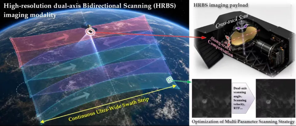
Figure: Concept and implementation framework of high-resolution dual-axis bidirectional scanning imaging technology. Source: Wei et al., Remote Sensing, 2026.
Image quality remains the bottom line
As the scanning range expands, both the speed and direction of a ground target’s movement across the focal plane vary more dramatically. If charge transfer within the TDI detector cannot keep pace with the target image, the result will not be a wider high-definition image, but a wider blurred one.
The research team incorporated Earth’s rotation, drift angle, image rotation, spherical projection distortion, and row transfer frequency mismatch into a unified model. It then jointly optimized the dual-axis scanning trajectory and detector row frequency. Optimal trajectory and row-frequency parameters can be autonomously calculated and planned onboard in near real time according to orbital conditions.
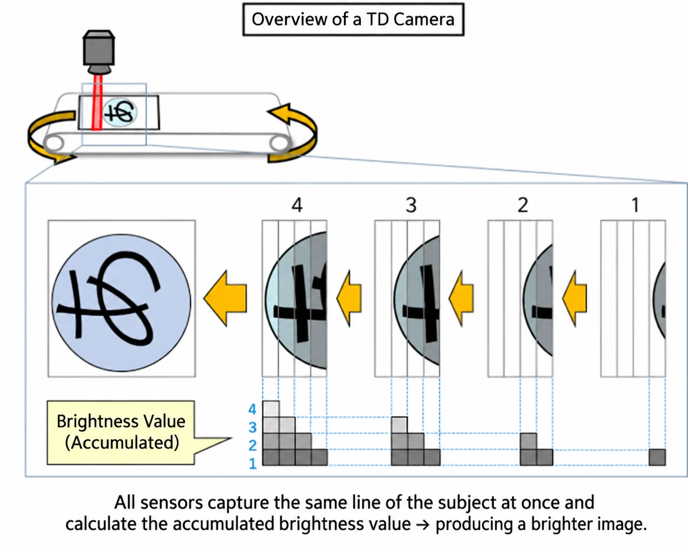
Figure: Spatiotemporal matching is critical during time-delay integration imaging. Matching errors cause image smear. Image source: Internet.
The study found that, without optimization, the maximum spatiotemporal matching error was approximately 16 pixels. Following joint optimization, the error across the entire scanning cycle was reduced to less than 0.1 pixels, preserving high image quality even at a high number of TDI stages.
The optimized results also showed strong robustness against errors in orbital positioning, satellite attitude, and satellite-to-ground clock synchronization. This indicates that the dynamic imaging architecture has both a sound mathematical foundation and potential commercial feasibility.
In the editor’s view, the technology will still need to overcome several engineering challenges before it can mature into a commercial product. These include highly stable dual-axis scanning mirror mechanisms, vibration suppression, thermal stability, high-speed TDI detectors, and drive electronics.
That is precisely why the significance of this research does not lie in presenting a ready-made solution. Instead, it identifies a possible direction for the evolution of commercial Earth observation imaging in the era of AI in space.
For commercial space-based Earth observation, the attraction of this approach extends beyond a swath-width figure that is several dozen times greater. Its real value is its potential to change the amount of useful information generated per orbital pass, per satellite, and per customer delivery.
This is what the convergence of Earth observation and AI in space ultimately means: not producing more pixels, but moving one step closer to the vision of a live view of Earth.
China’s advantage lies in its increasingly integrated capabilities across satellite manufacturing, constellation deployment, optical payloads, space-based computing, and downstream applications. Organizations can explore available data through the STARPATH GLOBAL satellite imagery catalog, or contact the team to discuss tailored coverage, resolution, and delivery requirements. As imaging and AI become more closely connected, this broad industrial foundation can help turn China’s expanding space capabilities into timely, decision-ready intelligence for global users.
Sources
[1] Wei, J. et al. Enabling More Efficient Dynamic Earth Observation: Wide-Area, High-Resolution Dual-Axis Bidirectional Scanning Imaging and the Associated Multi-Parameter Optimization. Remote Sensing, 2026, 18, 2364.
[2] Space computing constellation: Xinhua News Agency, May 14, 2025, “China Launches Space Computing Satellite Constellation with In-Orbit Computing Capabilities”; February 13, 2026, “‘Three-Body Computing Constellation’ Achieves Breakthrough in Inter-Satellite Networking.”
[3] Optical inter-satellite data relay: JAXA, World’s First Successful Transmission of Huge Volume Mission Data Using 1.5 μm Optical Inter-Satellite Communication, January 23, 2025.
[4] High-frequency commercial Earth observation coverage: Planet materials on PlanetScope’s near-daily coverage of the world’s landmass and Planet Tasking’s high-resolution, sub-daily tasking capabilities for priority areas.
[5] Onboard AI for Earth observation: ESA materials on Φsat-2, which entered its science operations phase in 2025 to validate onboard AI applications such as cloud detection and vessel recognition.