Several years ago, wheat farmers in Gansu Province, China, faced a familiar challenge. By the time they noticed yellow rust symptoms spreading across their fields, significant yield losses had already occurred. Traditional field inspections were slow, labor-intensive, and often unable to cover large agricultural areas. Today, however, the story is very different. Through advanced crop health monitoring technologies, farmers can detect disease outbreaks, nutrient deficiencies, drought stress, and pest infestations long before they become visible to the naked eye.
The rapid development of crop health monitoring via satellite solutions has transformed agricultural management worldwide. Modern crop health monitoring systems combine satellite imagery, artificial intelligence, weather data, and predictive analytics to provide actionable insights for farmers. Through satellite-based crop health monitoring, growers can monitor thousands of hectares simultaneously, reducing costs while increasing productivity.
Today, crop health monitoring is no longer limited to manual scouting. Farmers increasingly rely on crop health monitoring using remote sensing, crop health monitoring using AI, and even crop health monitoring drones to identify issues before they impact yields. Whether through satellites, UAVs, or integrated decision-support platforms, modern crop health monitoring technology is helping agricultural operations improve profitability while promoting sustainable farming practices.
Why Crop Health Monitoring Matters
Crop health directly influences agricultural productivity, food security, and farm profitability. Even minor stresses can significantly reduce yields if left undetected.
Common crop stress factors include:
▪ Pest infestations
▪ Plant diseases
▪ Drought conditions
▪ Nutrient deficiencies
▪ Flooding damage
▪ Cold and frost injury
▪ Soil degradation
Traditional scouting methods often identify problems only after visible symptoms appear. Satellite monitoring enables earlier detection, allowing corrective actions before losses escalate.
How Satellite-Based Crop Health Monitoring Works
Remote Sensing Fundamentals
Plants interact with sunlight in unique ways. Healthy crops reflect and absorb light differently from stressed crops. Satellites equipped with multispectral and hyperspectral sensors capture this information and convert it into measurable vegetation indicators.
Through crop health monitoring using remote sensing, analysts can evaluate:
▪ Plant vigor
▪ Chlorophyll content
▪ Canopy density
▪ Water stress levels
▪ Disease symptoms
▪ Growth patterns
By analyzing changes over time, farmers gain valuable insights into field conditions without physically inspecting every acre.
The Role of NDVI and Vegetation Indices
One of the most widely used indicators is the Normalized Difference Vegetation Index (NDVI). Platforms such as Satsure NDVI crop health monitoring solutions utilize NDVI data to evaluate vegetation health and identify anomalies.
NDVI measures the difference between near-infrared and red light reflected by plants. Healthy vegetation reflects more near-infrared light and absorbs more red light, creating higher NDVI values.
Benefits include:
▪ Early stress detection
▪ Improved yield forecasting
▪ Better fertilizer planning
▪ Efficient irrigation management
AI-Powered Disease and Pest Detection
One of the most advanced developments in agriculture is crop health monitoring AI.
Large-scale disease monitoring models combine multi-temporal satellite imagery with machine learning algorithms to identify disease patterns across extensive agricultural regions.
Researchers have found that while satellite monitoring successfully detects disease outbreaks, distinguishing between biotic stresses (pests and diseases) and abiotic stresses (drought, frost, heat) can be challenging. AI models address this issue by analyzing multiple variables simultaneously.
Modern crop health monitoring using AI platforms incorporate:
▪ Satellite imagery
▪ Weather conditions
▪ Historical disease records
▪ Soil information
▪ Crop growth models
▪ Machine learning predictions
This integration significantly improves detection accuracy.
Case Study: Wheat Stripe Rust Prediction in Gansu
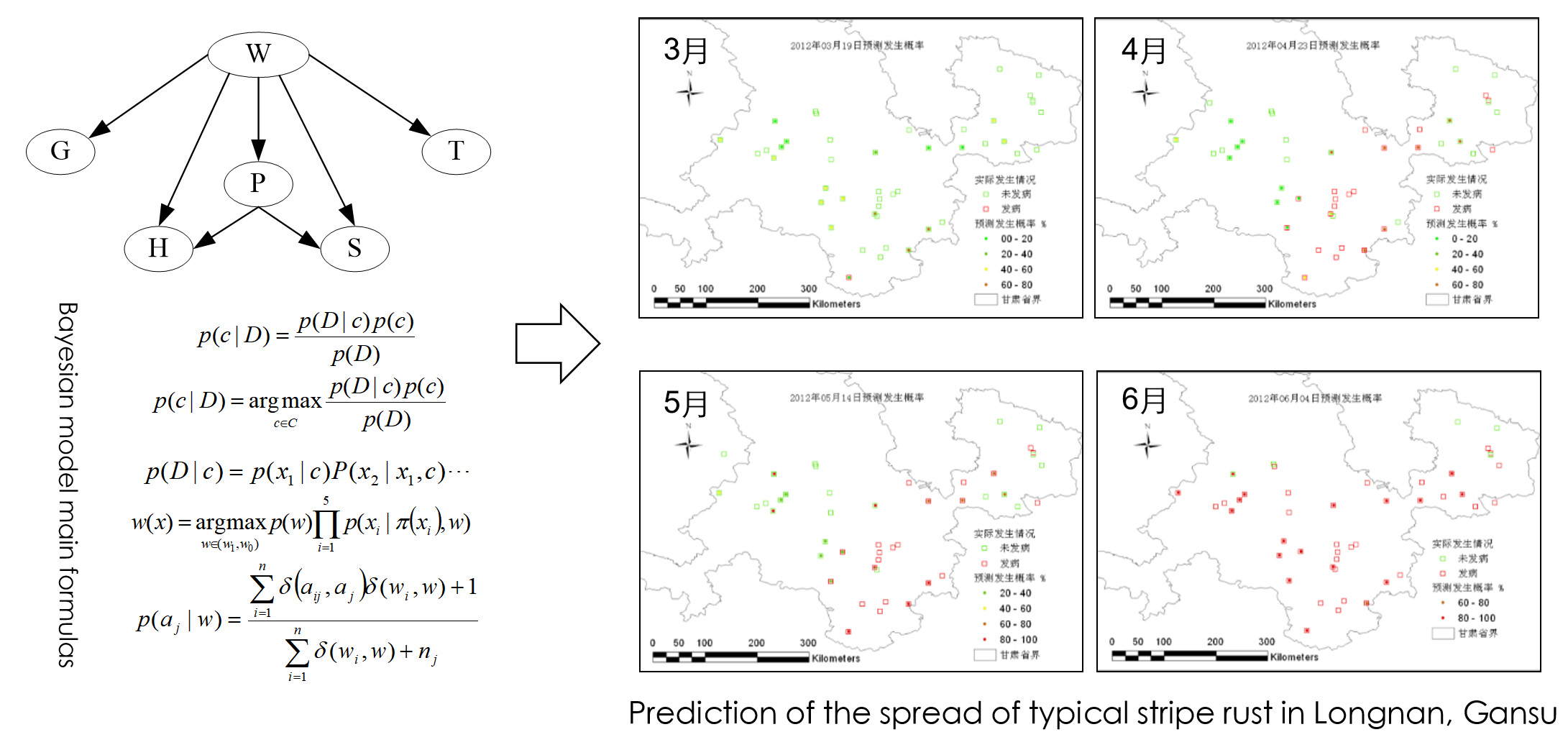
One successful implementation involved wheat stripe rust monitoring and forecasting in Longnan, Gansu Province.
Scientists developed a regional disease prediction model based on:
▪ Wind field analysis
▪ Temperature monitoring
▪ Humidity tracking
▪ Crop growth remote sensing data
▪ Bayesian network algorithms
The model successfully predicted disease spread patterns before severe outbreaks occurred. Farmers received early warnings, allowing them to apply targeted treatments rather than blanket pesticide applications.
Benefits included:
▪ Reduced pesticide costs
▪ Lower yield losses
▪ Improved environmental sustainability
▪ Better resource allocation
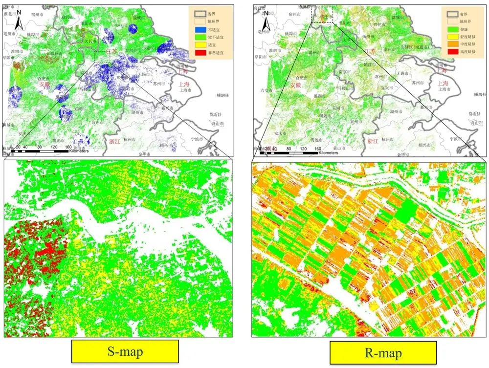
Case Study: Rice Sheath Blight Monitoring in Eastern China

Researchers in Jiangsu, Zhejiang, and Anhui provinces developed an advanced rice disease monitoring framework.
The system combined:
▪ Meteorological information
▪ Satellite-derived growth maps (S-map)
▪ SBSI vegetation indices from GF-1 satellite imagery
▪ Disease grading maps (R-map)
By integrating crop growth and disease indicators, researchers generated a comprehensive disease monitoring product called P-map.
The resulting disease distribution maps closely matched field observations and plant protection reports across the Yangtze River Basin.
This demonstrated the effectiveness of satellite-based crop health monitoring for large-scale agricultural disease management.
Case Study: Grasshopper Monitoring in Inner Mongolia
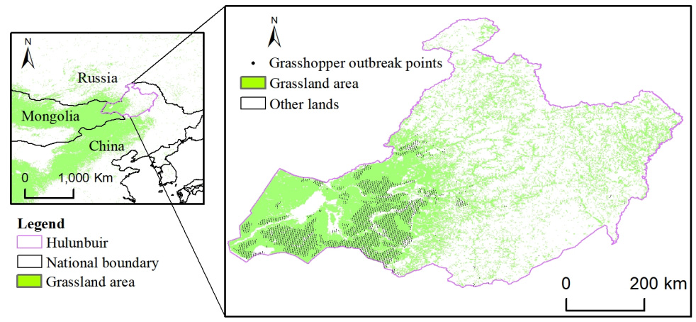
Spatial distribution of Hulunbuir Grassland.
Another significant success involved grasshopper habitat suitability monitoring in the Hulunbuir grasslands of Inner Mongolia.
Research Objectives
The project aimed to understand how grasshopper habitats changed between 2008 and 2020.
Data Sources
▪ Meteorological datasets
▪ Digital elevation models (DEM)
▪ MOD11A2 remote sensing products
▪ MOD13Q1 vegetation products
▪ Fractional Vegetation Cover (FVC)
▪ Temperature Vegetation Dryness Index (TVDI)
▪ Soil data
▪ Vegetation classification maps
Methodology
The Maxent ecological niche model analyzed six major grasshopper species and identified habitat suitability patterns.
Results
Researchers discovered that eastern grasslands consistently exhibited higher suitability indices, while northern and western regions generally maintained lower suitability levels.
This early-warning system enables agricultural authorities to deploy preventive measures before large-scale infestations occur.
Combining Satellites and Crop Health Monitoring Drones
Although satellites provide broad coverage, many farms also deploy crop health monitoring drones for detailed inspections.
A typical workflow involves:
▪ Satellite detection of abnormal field zones
▪ Drone deployment for closer inspection
▪ AI analysis of drone imagery
▪ Targeted intervention recommendations
This combination creates a highly efficient monitoring strategy.
Benefits of Crop Health Monitoring Using Drones
▪ Higher image resolution
▪ Flexible deployment schedules
▪ Rapid field verification
▪ Precision treatment planning
▪ Reduced scouting costs
As a result, many producers are investing in crop health monitoring using drones to complement satellite monitoring programs.
Best Drones for Crop Health Monitoring
Many agricultural operations combine satellites with the best drones for crop health monitoring.
Popular features include:
▪ Multispectral cameras
▪ Thermal sensors
▪ RTK positioning systems
▪ AI-powered analytics
▪ Automated flight planning
When integrated with satellite data, drone platforms provide unprecedented visibility into field conditions.
Remote Sensing Fertilization Decision Models
Fertilizer optimization represents another major application of remote sensing technology.
Researchers developed an innovative “soil-based basal fertilizer plus crop-based topdressing” decision model that received China’s Shennong Agricultural Science and Technology Award.
Soil-Based Basal Fertilization
The model integrates:
▪ Satellite yield estimation
▪ Soil testing databases
▪ Historical production records
▪ Nutrient requirement models
Crop-Based Topdressing
Real-time monitoring identifies crop growth conditions and recommends variable-rate fertilizer applications.
This approach reduces fertilizer waste while maximizing yield potential.
The Rise of Real Time Crop Health Monitoring Systems
Modern agriculture increasingly relies on the real time crop health monitoring system concept.
These platforms continuously process:
▪ Satellite imagery
▪ Weather forecasts
▪ Soil moisture data
▪ Pest alerts
▪ Drone observations
▪ Farm equipment telemetry
Farm managers receive alerts immediately when abnormalities are detected, enabling faster responses.
Crop Health Monitoring Software Development Services
As demand grows, many agribusinesses seek specialized crop health monitoring software development services.
Custom platforms often include:
▪ Satellite data integration
▪ AI prediction engines
▪ Drone connectivity
▪ Mobile dashboards
▪ Farm management systems
▪ Yield forecasting modules
These solutions allow agricultural organizations to tailor monitoring capabilities to specific crops and regions.
Economic Benefits of Crop Health Monitoring Technology
Adopting advanced crop health monitoring technology generates measurable financial returns.
Typical benefits include:
▪ 10–30% reduction in pesticide use
▪ 15–25% improvement in fertilizer efficiency
▪ Earlier disease intervention
▪ Reduced scouting labor costs
▪ Increased crop yields
▪ Better harvest planning
Large farming operations often recover implementation costs within a few growing seasons.
The Future of Monitoring Crop Health
The future of monitoring crop health lies in integrating satellites, AI, drones, weather intelligence, and precision agriculture systems into a unified decision-support platform.
Emerging technologies include:
▪ Hyperspectral satellite imaging
▪ Edge AI analytics
▪ Autonomous drone fleets
▪ Digital twin farms
▪ Predictive disease forecasting
▪ Automated treatment recommendations
These innovations will make agriculture more productive, sustainable, and resilient to climate challenges.
Partner with Starpath Global for Advanced Agricultural Intelligence
As satellite imagery, AI analytics, and remote sensing technologies continue transforming agriculture, organizations need experienced partners capable of turning data into actionable results.
Starpath Global helps agricultural enterprises, agritech companies, government agencies, and research institutions implement advanced solutions for crop health monitoring, crop health monitoring via satellite, crop health monitoring AI, drone integration, predictive analytics, and precision agriculture workflows.
Whether you are exploring a new crop health monitoring system, developing custom agricultural software, implementing satellite intelligence platforms, or building next-generation remote sensing applications, Starpath Global can help accelerate your digital agriculture initiatives and maximize return on investment.
With the growing importance of satellite-based crop health monitoring, organizations that adopt these technologies today will be better positioned to improve yields, reduce costs, and strengthen long-term agricultural sustainability.