
A research team from Beijing Institute of Technology (BIT) has developed an integrated hyperspectral imaging system capable of real-time analysis at the edge, overcoming a long-standing bottleneck in hyperspectral applications caused by massive data processing requirements.
The breakthrough, led by academician Zhang Jun’s team at BIT, introduces a new on-chip spectral computing architecture that moves hyperspectral reconstruction and analysis from external computing platforms directly into the imaging device. The research was published in the journal Science on Aug. 28, 2026.

The technology enables hyperspectral cameras to perform real-time processing in dynamic environments, opening potential applications in Earth observation, autonomous driving, environmental monitoring, industrial inspection, precision agriculture and biomedical imaging.
Moving hyperspectral imaging from offline processing to real-time intelligence
Hyperspectral imaging captures information across hundreds of spectral bands, allowing systems to identify materials and analyze chemical characteristics based on their unique spectral signatures. Unlike conventional cameras that record only visible colors, hyperspectral sensors acquire a continuous spectral “fingerprint” of objects.
The technology has become an important sensing method for applications ranging from satellite remote sensing and mineral exploration to industrial quality control and medical diagnostics. However, the large volume of hyperspectral data generated by these systems has historically limited their deployment outside controlled environments.
Conventional hyperspectral systems often generate large volumes of raw data that must be transferred to a more powerful computer for subsequent reconstruction and classification. This approach introduces latency, requires substantial computing infrastructure and restricts applications that require immediate decisions.
BIT’s new architecture aims to change this model by enabling “sensing and analysis at the same time,” allowing hyperspectral systems to perform reconstruction, recognition and information extraction directly on the device.
New computing architecture replaces conventional processing approach
According to the research team, conventional hyperspectral processing relies heavily on general-purpose computing architectures based on CPUs and GPUs. These systems follow the traditional von Neumann computing model, where data repeatedly moves between memory and processors, creating bottlenecks when processing high-throughput spectral information.
The BIT team proposed a new “data-domain-like parallel computing” method, mapping the complete spectral computation process directly onto the physical structure of a chip.
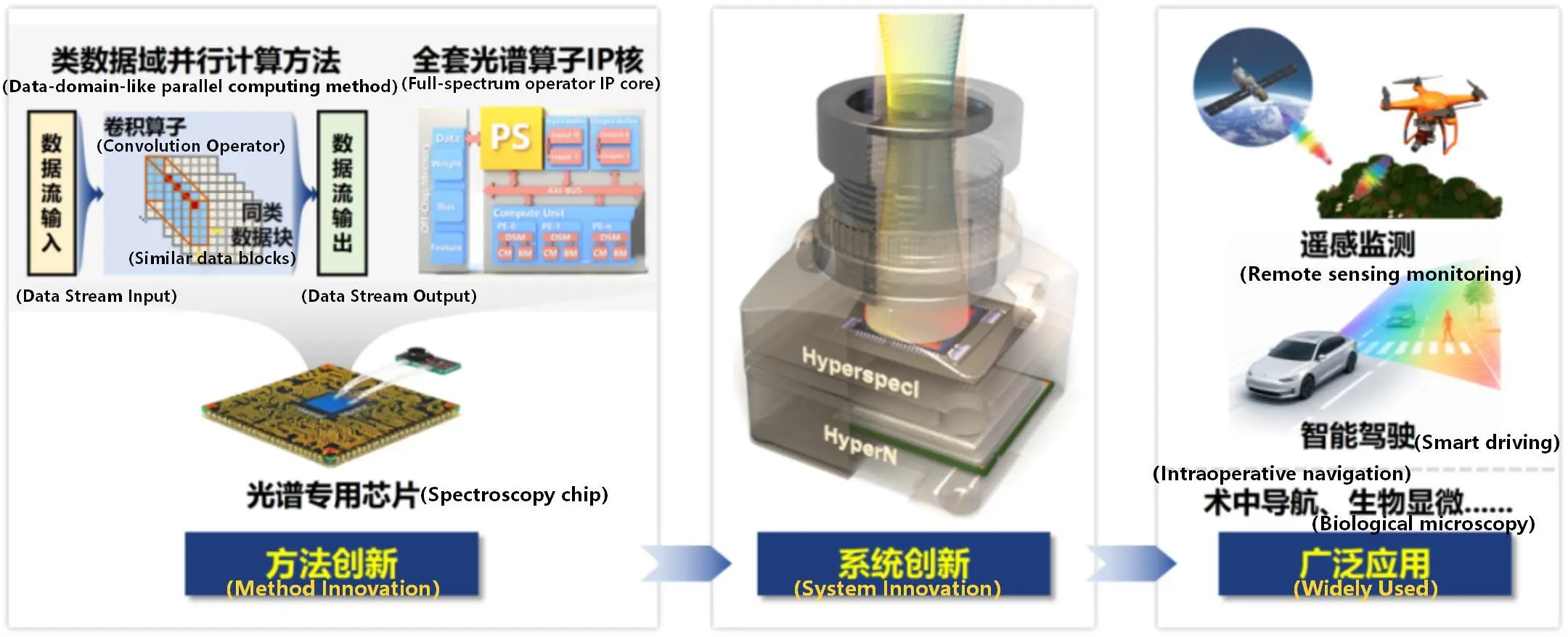
On-chip spectral computing architecture. Source: Beijing Institute of Technology
Instead of relying on sequential processing, the architecture uses distributed hardware operators to form a continuous data-stream processing pathway. This design reduces idle periods in computing pipelines and allows spectral calculations to be performed in parallel as data is generated.
The approach represents a shift from conventional “collect first, analyze later” hyperspectral imaging toward “in-situ, online computation” integrated within the sensing device.
From an engineering perspective, this type of architecture addresses one of the key challenges in deploying advanced imaging systems outside laboratories: balancing sensor performance, computing capability, size, weight and power consumption. Similar trends are shaping next-generation Earth observation payloads, autonomous systems and edge AI platforms, where reducing dependence on cloud or ground processing is becoming increasingly important.
HyperVision integrates sensor, processor and AI algorithms into a portable system
Building on the new computing architecture, the team developed HyperVision, described by BIT as the world’s first integrated online real-time hyperspectral imaging microsystem.
The system combines a custom hyperspectral computing chip, HyperN, with a broadband hyperspectral imaging sensor, HyperspecI, along with battery modules and an integrated display.
The complete device weighs approximately 950 grams and consumes 25.3 watts of power. Compared with conventional GPU-based processing solutions, the system reduces power consumption by roughly an order of magnitude, according to the research team.
HyperVision can operate without external power supplies or connection to external computing clusters, producing video-rate hyperspectral imaging results across the visible and near-infrared spectrum.
The development required integration across multiple technical areas, including high-density data-flow acceleration, dedicated spectral computing chip development and lightweight AI-based spectral reconstruction algorithms. The team completed the transition from theoretical architecture design to chip development and full-system integration.
This full-stack approach is increasingly important for advanced remote sensing systems. Satellite and airborne payload designers have traditionally faced trade-offs between imaging capability and onboard processing resources. More capable edge processing could allow future platforms to reduce downlink requirements by transmitting analyzed information rather than only raw imagery.
Field demonstrations highlight potential for remote sensing and autonomous systems
The research team has validated HyperVision in several dynamic environments, including intelligent driving, smoke monitoring and drone-based air-to-ground imaging.
For remote sensing applications, real-time hyperspectral analysis could improve the ability of airborne and space-based platforms to identify targets and generate actionable information closer to the point of observation. Potential use cases include environmental monitoring, disaster response, agricultural assessment and resource exploration.
In satellite systems, hyperspectral instruments have historically required significant onboard storage and ground processing capacity because of their high data rates. While HyperVision itself is a terrestrial microsystem, the underlying trend toward dedicated onboard spectral computing aligns with broader industry efforts to increase satellite autonomy and reduce dependence on ground infrastructure.
Commercial Earth observation companies are also pursuing similar directions by combining advanced sensors with onboard artificial intelligence. Companies such as Planet Labs, Maxar and Airbus Defence and Space have been investing in more automated satellite data processing workflows, although their approaches generally focus on large-scale orbital data platforms rather than portable hyperspectral systems.
Expanding the engineering pathway for next-generation hyperspectral systems
The BIT team’s latest achievement follows earlier work on on-chip optical encoding. In 2024, the group reported advances in improving the optical efficiency of chip-level hyperspectral imaging systems, with related research published in Nature.
The latest Science publication extends that progress by addressing the computing challenge after optical data acquisition, creating a more complete technology chain from optical sensing and chip design to real-time intelligent analysis.
Reviewers described the work as a deep optimization of system architecture, a significant technological advancement and an example of rare engineering maturity.
By combining specialized hardware computing with compact imaging systems, the technology points toward a new generation of embedded hyperspectral platforms that could operate in locations where conventional laboratory-scale instruments are impractical.
For the aerospace sector, such advances could become relevant to future Earth observation missions that require faster onboard interpretation, lower communication burdens and more autonomous decision-making capabilities.
From Real-Time Hyperspectral Imaging to Next-Generation Remote Sensing Applications
The development of real-time hyperspectral computing reflects a broader transformation in remote sensing: moving from systems that primarily collect large volumes of data toward intelligent sensing platforms capable of processing and interpreting information closer to the point of observation.
As satellite payloads, onboard computing and artificial intelligence continue to advance, future Earth observation systems are expected to deliver faster insights with less dependence on traditional ground-based processing workflows. These developments could support more efficient applications in agriculture, environmental monitoring, resource management, disaster response and other data-intensive industries.
At the same time, the rapid growth of China’s commercial space sector is expanding global access to satellite manufacturing capacity, launch services and Earth observation resources. More Chinese satellite companies are contributing additional capacity to the international market, creating new opportunities for users seeking competitive satellite imagery and payload solutions.
STARPATH GLOBAL connects global customers with China’s expanding space capabilities, providing satellite imagery and remote sensing solutions tailored to specific application needs. STARPATH GLOBAL helps customers select suitable satellite data and imaging resolutions based on their specific requirements, ensuring that users obtain the information they need without paying for unnecessary imaging capability.
For organizations seeking to translate satellite data into practical business value, STARPATH GLOBAL’s Forward Deployed Engineers (FDE) team helps bridge the gap between space technology and operational outcomes. Rather than simply providing imagery or software, FDE engineers work directly with customer teams to identify high-value opportunities, design practical remote sensing solutions and validate measurable business impact.
Organizations interested in exploring how satellite remote sensing can support their operations can contact the STARPATH GLOBAL FDE team to apply for the Pioneer Partner Program. Selected partners receive support in opportunity discovery, solution design, pilot validation and ROI assessment, helping them determine where satellite intelligence can create measurable value before committing to large-scale deployment.