Satellite remote sensing is moving beyond specialized surveying and scientific research into practical applications such as urban governance, agriculture, resource management and infrastructure monitoring.
This shift is particularly visible in China. In 2025, China launched more than 120 remote-sensing satellites, while its civilian remote-sensing satellite fleet in orbit exceeded 640, maintaining the country’s position as the world’s second-largest operator in this category. As optical, SAR, hyperspectral and infrared satellites continue to enter service, observation capabilities and data acquisition options are becoming increasingly diverse. The growth of commercial remote sensing is also lowering the barriers to adopting these technologies across industries.
An urban renewal project in Mianyang, Sichuan Province, offers an example of how satellite remote sensing is being integrated into urban infrastructure management.
The city is combining satellite remote sensing with underground pipeline inspection, BeiDou, drones and Internet of Things technologies to identify and address different types of risks affecting urban operations.
Trenchless Technology Repairs Underground Pipelines
In the eastern section of Mianyang Science and Technology City New Area, aging underground pipelines are being renovated using trenchless methods.
Workers first send pipeline inspection robots into underground pipes to examine their internal condition and determine the appropriate repair method based on the extent of damage. For pipelines requiring full-section rehabilitation, a liner impregnated with photosensitive resin is inserted into the existing pipe. Pressure is then applied to make the liner conform to the pipe wall before ultraviolet light is used to cure it, creating a new lining inside the old pipeline.
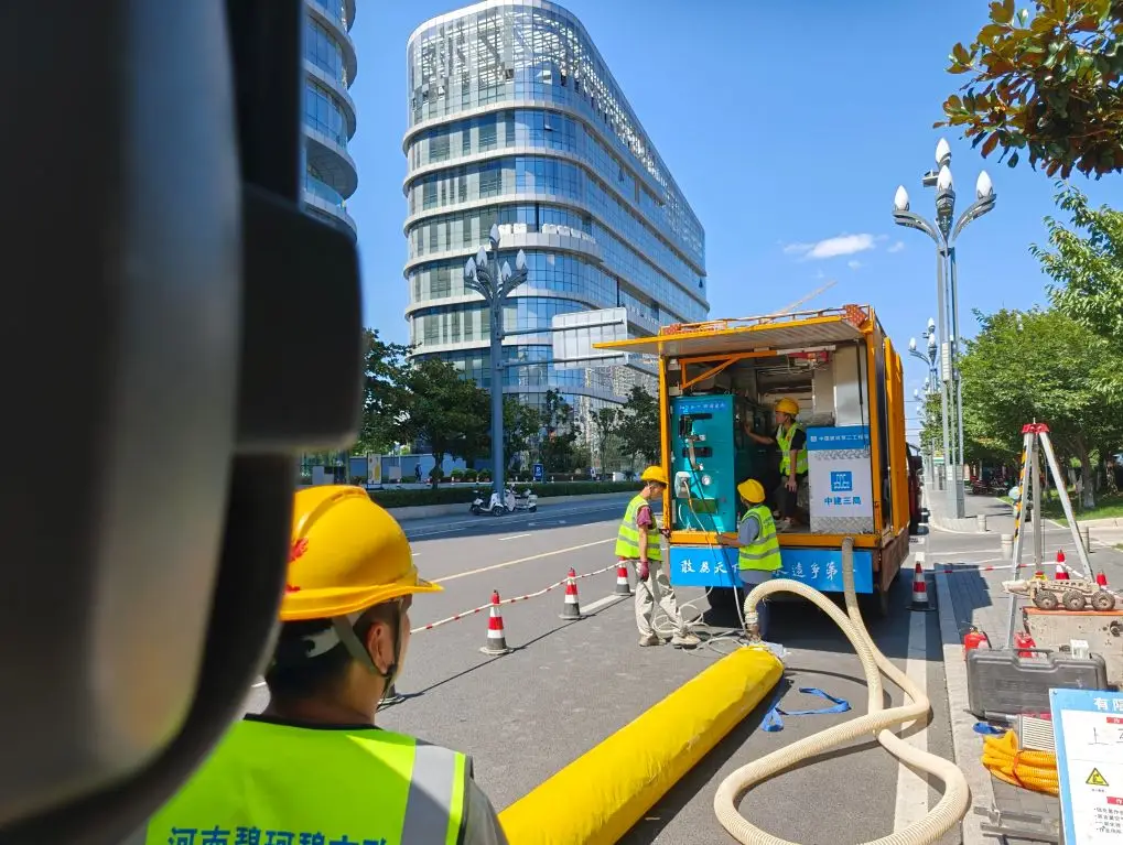
Construction workers carry out UV-cured trenchless rehabilitation of an underground pipeline. Photo by Xinhua News Agency reporter Li Like.
Compared with conventional excavation, the method reduces the need to dig up roads or close streets, minimizing disruption to surrounding traffic and residents.
Around nine kilometers of local pipeline rehabilitation projects using trenchless technology are now nearing completion. The equipment used in the process has been domestically produced, while overall labor costs can be reduced by more than 80%. For a pipeline section approximately 30 meters long, conventional excavation may take around a month, whereas trenchless rehabilitation can be completed in as little as one day.
While robots and trenchless technologies handle underground pipeline inspection and repair, satellites above the city are responsible for continuously monitoring changes in the ground surface.
SAR Satellites Help Detect Building Risks Earlier
In Mianyang’s Fucheng District, authorities have been conducting a SAR, or synthetic aperture radar, satellite monitoring pilot for nearly three years to identify ground deformation and potential building safety risks.
Traditional building safety inspections rely heavily on manual surveys, requiring personnel to inspect buildings one by one. SAR satellites, by contrast, can periodically observe large areas from an altitude of around 500 kilometers. Because radar observations can operate at night and through clouds and rain, SAR is particularly suitable for continuous, wide-area monitoring of ground deformation.
Fucheng District currently conducts a new scan of the urban area approximately every 11 days.
The value of SAR satellites goes beyond simply capturing imagery. By actively transmitting microwave signals and receiving the echoes reflected from the ground, changes between observations taken at different times can be analyzed to identify subtle surface displacement.
The C-band SAR satellites used locally operate at a wavelength of approximately 5.6 centimeters. Under ideal conditions, analysis of phase changes can identify millimeter-scale deformation, corresponding to ground displacement of around 2.8 millimeters.
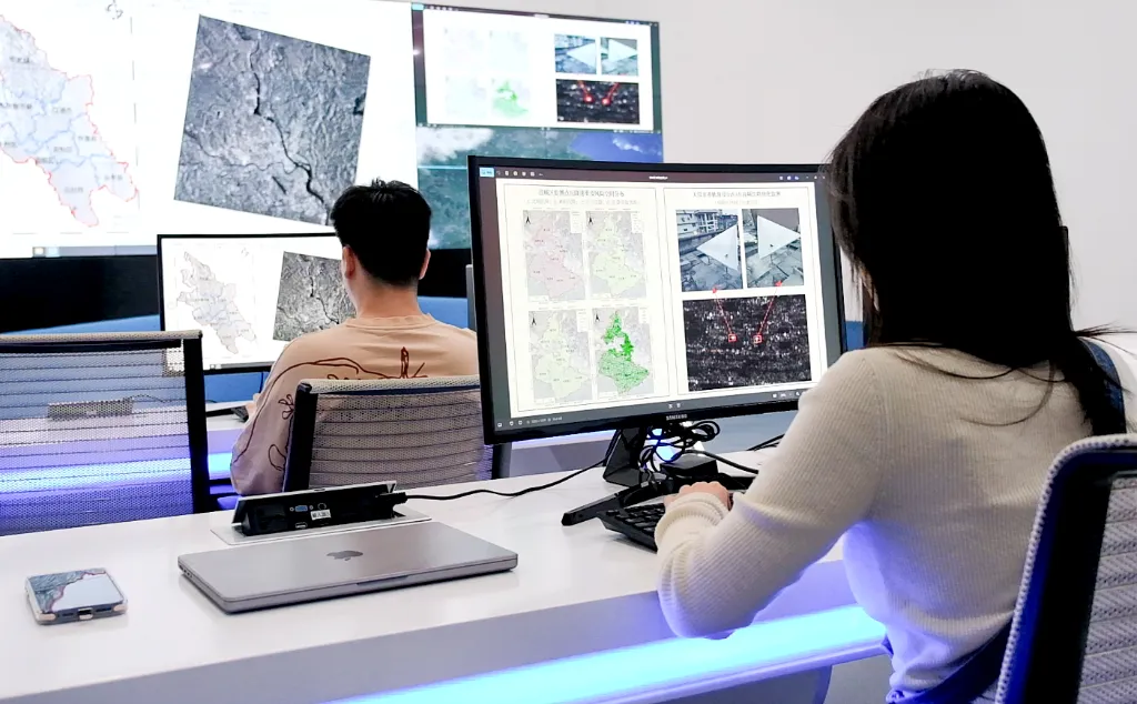
Staff operate the Fucheng-1 SAR remote-sensing satellite to monitor buildings on the ground. Photo courtesy of Xinhua News Agency.
This means that some structural or ground changes may already appear in satellite data before obvious cracks become visible to the human eye.
By the end of 2025, the Fucheng District pilot had identified 158 buildings suspected of presenting safety risks. On-site inspections subsequently confirmed that 30 were classified as Grade C or above hazardous buildings. Three Grade D hazardous buildings were flagged during the pilot and subsequently demolished, while another 35 buildings showed signs of damage such as cracking and subsidence and required enhanced inspection and maintenance.
In one case, a residential building showed no obvious cracks visible to the naked eye when the satellite monitoring system detected an anomaly and issued an alert. A subsequent on-site inspection found branching cracks in the walls.
Satellites are not replacing field inspections. Instead, they help authorities identify areas requiring attention from large volumes of wide-area data, allowing personnel to conduct targeted follow-up inspections rather than relying entirely on building-by-building manual surveys.
From Space to the Ground, an Integrated Urban Sensing System Is Emerging
SAR satellites do not operate in isolation within Mianyang’s urban renewal system.
The city has incorporated multiple technologies into its urban management framework. BeiDou technology is used to monitor key bridges, smart manhole covers track water accumulation and unauthorized opening, and robots inspect and help repair underground pipelines. Relevant information is then integrated into the city’s unified urban management platform.
Each technology therefore performs a different role.
Satellites detect changes across large areas, low-altitude platforms or on-site equipment provide further verification, and ground-based monitoring systems continuously track priority assets.
This coordinated space-air-ground approach can help urban authorities direct limited inspection resources toward areas that genuinely require attention, while gradually shifting infrastructure maintenance away from purely manual inspections toward more continuous and digital monitoring.
Satellite Remote Sensing Is Expanding Into More Practical Applications
Mianyang’s experience reflects the broader expansion of satellite remote-sensing applications across China.
From urban infrastructure and agriculture to natural resources and disaster monitoring, satellite remote sensing is being adopted across a growing range of industries. As satellite fleets expand and commercial remote sensing develops, users have access to an increasingly diverse range of observation capabilities. Satellite data is gradually evolving from a resource used primarily by specialized institutions into a service that can be integrated into operations across multiple industries.
For urban managers, the key issue is not simply how many satellites are available, but whether they can continuously obtain data covering their areas of interest and use that data to detect changes and identify risks in a timely manner.
Mianyang demonstrates that when satellite data is combined with field verification and other infrastructure-monitoring technologies, remote sensing can become part of practical, day-to-day urban management workflows.
From Applications in China to Overseas Markets
As China continues to expand its satellite manufacturing and remote-sensing capabilities, more satellites and data resources are becoming commercially available. For the industry, the next challenge is how to bring this growing capacity into a wider range of real-world applications.
Overseas markets offer significant opportunities.
Cities around the world face similar challenges, including aging buildings, land subsidence, infrastructure maintenance and urban expansion. Satellite remote sensing can provide wider-area and more frequently updated monitoring capabilities. At the same time, the continued development of China’s satellite manufacturing sector and broader space industry supply chain could enable more price-competitive satellite data and application services for international users.
Application models already validated in real-world urban governance environments such as Mianyang therefore have the potential not only to serve Chinese cities, but also to be adapted to local requirements and deployed in overseas markets.
International customers do not necessarily need a dedicated satellite of their own. What they need is an end-to-end capability that can solve specific infrastructure-monitoring problems—from satellite data acquisition and change detection to integration into operational workflows.
STARPATH GLOBAL connects China’s satellite remote-sensing capabilities with global market demand, providing Earth Observation data and analytics for urban planning and infrastructure applications. These services help users detect changes more efficiently, identify potential risks and integrate satellite capabilities into real-world operational workflows. Explore STARPATH GLOBAL’s Urban Planning solutions to discover how satellite remote sensing can support urban infrastructure monitoring and risk management.
For cities, infrastructure operators and project developers looking to apply similar satellite-based monitoring capabilities to their own markets, STARPATH GLOBAL can help turn specific requirements into deployable solutions. From selecting suitable satellite data and monitoring frequency to designing deformation detection and risk-identification workflows, apply for our limited-availability free FDE initiative, the Pioneer Partner Program, to work with our FDE engineers on a solution tailored to your project.