Planet Labs has received a $22 million contract option from the U.S. National Geospatial-Intelligence Agency (NGA) to continue providing artificial intelligence-enabled geospatial analytics for military and government users.
The award expands work that began under a $13 million contract issued last year through the NGA’s Luno B program, which uses unclassified commercial imagery and analytics to support U.S. defense and intelligence operations.
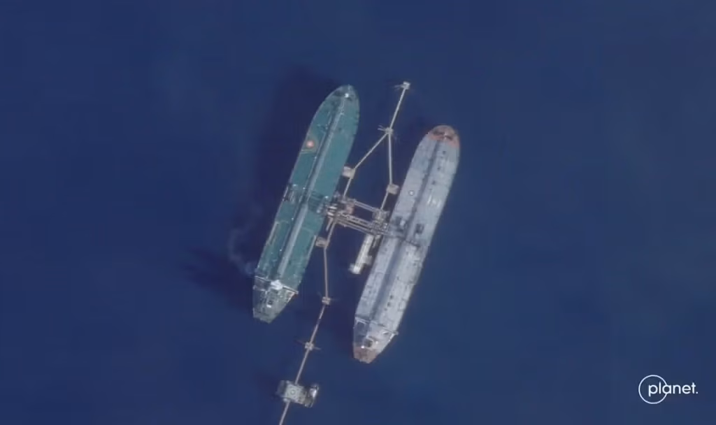
The latest contract covers Planet’s Advanced Analytics for Maritime Operations and Reconnaissance capabilities, which are designed to identify and monitor maritime activities through automated analysis of satellite imagery and other data sources.
Focus on Maritime Monitoring
According to Planet, the system supports automated detection of strategic and tactical maritime events, including ship-to-ship transfers and activity involving so-called “dark” fleets, where vessels operate with limited or disabled tracking signals.
The analytics are intended to provide U.S. Combatant Commands with additional situational awareness using unclassified commercial data products.
The work forms part of NGA’s broader effort to integrate commercial satellite imagery and artificial intelligence tools into operational decision-making and intelligence workflows.
Additional Monitoring Contract Awarded
Planet also announced a separate contract award from NGA in partnership with the U.S. Department of Defense’s Defense Innovation Unit (DIU).
Under that agreement, the company will provide its Global Monitoring Service (GMS), which delivers near-daily monitoring and change-detection capabilities using satellite imagery and automated analytics.
Financial terms of the second award were not disclosed.
The service utilizes imagery collected by Planet’s SuperDove Earth observation satellite constellation and combines it with AI-based analytics to identify changes and events across large geographic areas.
Faster Access to Geospatial Intelligence
Planet said the Global Monitoring Service is designed to deliver automated insights within hours of image collection, helping users identify emerging developments more rapidly.
“These solutions bridge the ‘last mile’ between raw data and actionable intelligence, democratizing access so that field operators can leverage complex geospatial insights without requiring advanced GIS (geographic information system) expertise,” said Jon Powers, vice president of Global Defense and Intelligence at Planet.
Growing Role of Commercial Space Data
The awards highlight the increasing role of commercial satellite operators in providing imagery, analytics and monitoring services to government agencies.
The NGA’s Luno program is designed to leverage commercially available, unclassified geospatial intelligence products to support military personnel, government decision-makers and international partners.
Planet operates one of the world’s largest Earth observation satellite constellations and has increasingly focused on combining imagery with artificial intelligence and analytics tools to support defense, intelligence and civil applications.