Every forest fire that spreads beyond control, every pipeline that fails before inspection, every harvest lost to disease that was visible from orbit weeks earlier — these are not failures of nature. They are failures of data.
Across Southeast Asia and the Middle East, governments and corporations are making decisions about their most critical assets — farmland, forests, infrastructure, water systems — using information that is months old, incomplete, or gathered at enormous human cost. Meanwhile, the answers they need have been passing overhead at 500 kilometers altitude, every single day, unseen.
The problem is not the absence of satellites. It is the absence of a partner who can translate what those satellites see into decisions you can act on today.
| 7-14
DAYS EARLIER CROP DISEASE CAN BE DETECTED FROM ORBIT THAN BY FIELD INSPECTION |
50%+
REDUCTION IN EARLY-STAGE MINERAL EXPLORATION COST WITH HYPERSPECTRAL MAPPING |
4 hrs
FASTEST DISASTER IMAGERY DELIVERY FROM OUR CONSTELLATION PARTNERS, GLOBALLY |
The Three Crises Hidden in Plain Sight
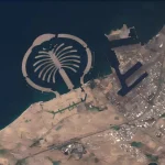
The EUDR compliance deadline is real. Starting in 2026, any company exporting timber, palm oil, soy, cocoa, cattle products, coffee, or rubber into the European Union must prove that their supply chain is deforestation-free — with geographic coordinates, dated evidence, and a documented due-diligence process. Traditional ground surveys cannot scale to cover the area required. Satellite-derived, legally defensible deforestation monitoring is no longer a competitive advantage. It is a market entry requirement.
Critical infrastructure is aging invisibly. Dams, embankments, transmission towers, and pipelines deform millimeters at a time before they fail catastrophically. A coal mine in Inner Mongolia subsided at 20–30mm per year before its collapse. A bridge in Italy showed measurable displacement months before 43 people died. Interferometric SAR satellites — the same technology in our partner constellation — detect structural movement at millimeter precision, continuously, without a single site visit.
Natural resources are being found — or missed — on legacy intelligence. The geological surveys many nations rely on are decades old. Hyperspectral imaging can identify mineral alteration zones, map vegetation stress over entire river basins, and distinguish tree species across millions of hectares of forest — delivering the kind of resource intelligence that used to require years of fieldwork, now in weeks.
“We can no longer rely on localized, reactive human observation to manage dynamic, planetary-scale challenges. The technology to see clearly already exists. What is missing is a trusted partner who can deploy it.”
What It Means to Have Complete Coverage
Consider what changes when every relevant authority — a ministry of agriculture, a national forestry commission, an energy infrastructure operator — has continuous, automated, satellite-derived intelligence about the assets they are responsible for.
Early fire detection reduces suppression costs and saves lives. Deforestation alerts arrive before the clearing is complete, while enforcement is still possible. Pipeline leaks are flagged by trace gas signatures before they become spills. Crop nutrition deficiencies are mapped before yield loss is locked in. Structural subsidence at a reservoir triggers inspection before water management becomes crisis management.
This is not a future possibility. These are operational capabilities, deployed now, generating results in countries that have made the decision to act.
The Cost of Waiting Is Not Zero
Every month without continuous monitoring is a month of deformation data that no longer exists. Every season without crop stress mapping is yield loss that cannot be recovered. Every year that forest change goes undetected is carbon credit and compliance exposure that compounds.
The organizations that are building space-based monitoring capabilities today will have a multi-year intelligence advantage over those that begin in two or three years. Archive data — the historical record of how an asset has changed — is only valuable if you started collecting it.
The question for government ministries, state enterprises, and institutional landowners is not whether Earth observation intelligence is relevant to their mandate. The question is whether they intend to be among the first to deploy it, or among the last.