Navigational satellite constellations serve as the foundational infrastructure for global positioning systems (GPS), global navigation satellite systems (GNSS) and other satellite-based navigation technologies. By providing precise positioning, navigation, and timing (PNT) services, these constellations have become indispensable across a wide spectrum of civilian, scientific and military applications. They guide aircraft, maritime vessels and ground transportation, while also enabling emerging technologies such as autonomous vehicles, smart city networks and Internet of Things (IoT) devices. Beyond everyday convenience, navigational satellites play a pivotal role in disaster management, resource mapping, geospatial research and defense operations making them a cornerstone of modern technological and strategic systems worldwide.
What Are Navigational Satellite Constellations?
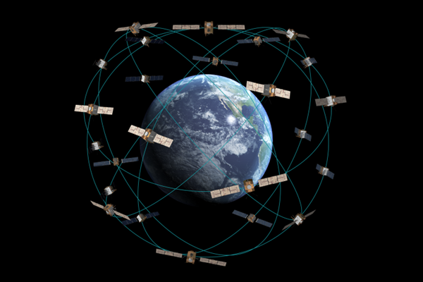
A navigational satellite constellation is a group of satellites working together in orbit to provide continuous and reliable location, timing, and navigation services across the globe. Unlike single satellites, constellations ensure redundancy, wide coverage and high precision by distributing satellites across medium Earth orbit (MEO), geostationary orbit (GEO), or inclined orbits. Each satellite continuously broadcasts signals containing highly accurate timing information and orbital data, which are received by devices such as smartphones, vehicle navigation systems, aircraft avionics and maritime navigation tools. By analyzing signals from multiple satellites, these receivers can calculate precise positions, often achieving sub-meter or even centimeter-level accuracy, making navigational constellations indispensable for modern transportation, defense, scientific research and emerging technologies like autonomous vehicles and IoT networks.
Role of GPS and GNSS in Satellite Navigation

1. GPS (Global Positioning System): The Global Positioning System (GPS), developed and operated by the United States Department of Defense, is the most widely adopted navigation system across the world. It comprises over 30 operational satellites in medium Earth orbit (MEO), ensuring that a minimum of four satellites are always visible from any location on Earth to provide accurate positioning and timing. GPS enables a wide range of applications, from civilian navigation in smartphones and vehicles to military operations, disaster response and scientific research.
2. GNSS (Global Navigation Satellite Systems): Global Navigation Satellite Systems (GNSS) is an umbrella term that encompasses all global and regional navigation constellations, including GPS, GLONASS, Galileo, BeiDou, NavIC and QZSS. GNSS aims to provide multi-constellation and multi-frequency coverage, which enhances positioning accuracy, reliability, and resilience, particularly in challenging environments such as urban canyons or dense forests. By integrating signals from multiple constellations, GNSS ensures more robust navigation solutions than relying on GPS alone, supporting a wide spectrum of applications from autonomous vehicles to geospatial mapping and precision agriculture.
Key GNSS Constellations Include:
- GPS (USA): The pioneering global system providing worldwide navigation coverage.
- GLONASS (Russia): Russia’s counterpart to GPS, offering global positioning services.
- Galileo (European Union): Europe’s independent GNSS, focused on high-precision civil applications.
- BeiDou (China): China’s global navigation system with regional and global coverage capabilities.
- NavIC (India – regional): India’s regional system providing precise navigation within the Indian subcontinent.
- QZSS (Japan – regional): Japan’s regional system optimized for the Asia-Oceania region, enhancing GPS reliability.
How Navigational Satellite Constellations Work?

1. Satellite Signal Transmission: Each navigational satellite continuously broadcasts coded radio signals that include its precise orbital position and exact time, maintained by onboard ultra-stable atomic clocks. These signals are carefully synchronized across the entire constellation to ensure that receivers on Earth can accurately calculate distances to multiple satellites simultaneously. The combination of precise timing and positional information forms the foundation of accurate global navigation and timing services.
2. Receiver Triangulation: To determine its exact location, an Earth-based receiver must capture signals from at least four satellites. Signals from three satellites are used to calculate the receiver’s latitude, longitude, and altitude through trilateration, while a fourth satellite is essential to correct any discrepancies in the receiver’s internal clock. This process ensures high-precision positioning, often achieving sub-meter to centimeter-level accuracy depending on the system and additional correction methods.
3. Orbit and Coverage: Most GNSS satellites operate in medium Earth orbit (MEO) at an altitude of approximately 20,000 kilometers, completing one orbit roughly every 12 hours. This orbital configuration provides consistent global coverage while reducing atmospheric interference compared to low Earth orbit (LEO) satellites. The strategic spacing of satellites ensures redundancy, so even if one satellite is temporarily unavailable, others in the constellation maintain uninterrupted navigation services.
Major Navigational Satellite Constellations

1. GPS (USA): The Global Positioning System (GPS), operated by the U.S. Space Force, is the world’s most widely used navigation system for both civilian and military applications. It comprises over 30 satellites in medium Earth orbit, ensuring that at least four satellites are visible from any location on Earth at all times. Civilian users achieve accuracy of under 5 meters, while military applications utilizing encrypted signals can reach sub-meter precision.
2. GLONASS (Russia): GLONASS is Russia’s counterpart to GPS, providing global positioning, navigation, and timing services. The system operates approximately 24 satellites in MEO, offering reliable coverage even in high-latitude regions such as the Arctic. GLONASS is widely used in aviation, defense operations and civilian applications within Russia and allied countries.
3. Galileo (European Union): Galileo is the European Union’s independent global navigation system, designed to offer high-accuracy positioning and timing services worldwide. Civilian users can achieve roughly 1-meter accuracy, while the high-precision commercial service provides centimeter-level positioning. Galileo enhances global navigation security and reduces dependence on foreign satellite systems.
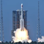
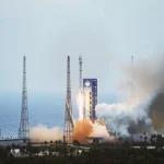
4. BeiDou (China): China’s BeiDou Navigation Satellite System, completed in 2020 with over 35 satellites, provides comprehensive global Positioning, Navigation, and Timing (PNT) services. It includes regional augmentation features that improve reliability and accuracy across Asia-Pacific. BeiDou supports applications ranging from civilian navigation to military, aviation and maritime operations.
5. NavIC (India): The Navigation with Indian Constellation (NavIC) is India’s regional satellite navigation system, also known as the Indian Regional Navigation Satellite System (IRNSS). It delivers positioning and timing services across India and the Indian Ocean region, providing critical support for disaster management, fisheries, transportation and defense operations. NavIC is increasingly integrated into mobile devices and regional navigation applications.
6. QZSS (Japan): The Quasi-Zenith Satellite System (QZSS) is Japan’s regional satellite network designed to augment GPS coverage in the Asia-Pacific region. QZSS improves accuracy and reliability for users in urban canyons and mountainous terrain, where conventional GPS signals may be obstructed. It is often referred to as the “GPS augmentation system for Japan,” supporting applications in transportation, disaster response and location-based services.
Applications of Navigational Satellite Constellations

1. Civil and Commercial Applications: Navigational satellites have become indispensable for everyday civil and commercial use. Smartphones and navigation apps, such as Google Maps and ride-hailing services like Uber, rely on GPS and GNSS signals to provide accurate real-time location and route guidance. In agriculture, precision farming uses satellite data to monitor crop health, optimize irrigation and improve yields, while transportation sectors including aviation, shipping and railways benefit from reliable tracking and route management. Additionally, during disasters, satellites support search and rescue operations, emergency communications and coordination of relief efforts, making them vital for public safety.
2. Military and Defense: Satellites play a critical role in modern military operations, providing precise positioning and timing essential for defense strategies. Missile guidance systems depend on GNSS for accurate targeting and navigation, while secure satellite communications ensure that battlefield networks remain operational even in contested environments. Satellites also support surveillance and reconnaissance missions, enabling real-time monitoring of adversary movements and strategic intelligence gathering which strengthens national security.
3. Scientific and Industrial Applications: Navigational satellites are essential tools for scientific research and industrial operations. Space missions, including interplanetary probes, rely on satellites for accurate trajectory and orbital navigation. In geodesy, satellites help measure Earth’s shape, monitor tectonic activity and detect crustal movements, contributing to earthquake studies and geological research. Furthermore, timing synchronization provided by GNSS is crucial for industrial and infrastructure systems, including financial networks, power grids, and telecommunications, ensuring efficiency and reliability across critical sectors.
Importance of Navigational Satellite Constellations in Modern Technology
- Global Connectivity: Navigational satellite constellations play a key role in enabling global connectivity by providing accurate positioning and timing for satellite internet, 5G networks, and IoT devices. These systems allow seamless integration between terrestrial and space-based networks, ensuring that even remote areas can benefit from reliable digital services. The continuous coverage provided by GNSS is essential for connecting devices, vehicles and infrastructure across the globe.
- Economic Impact: GNSS-based services have a profound economic influence, contributing billions of dollars annually to global industries. Sectors like logistics, transportation, agriculture and finance rely heavily on precise timing and positioning data to operate efficiently. The accuracy and reliability of navigational satellites drive innovation, productivity and commercial opportunities in both established and emerging markets.
- National Security: Independent satellite constellations strengthen national security by reducing reliance on foreign navigation systems. They provide secure and resilient communication, surveillance, and targeting capabilities for defense applications. This autonomy ensures that military operations, emergency responses and strategic infrastructure remain functional even if external systems are unavailable or compromised.
- Next-Generation Mobility: Navigational satellites are foundational for next-generation mobility technologies, including autonomous vehicles, drones and smart logistics networks. High-precision positioning enables safe navigation, traffic management and efficient route planning in real time. As autonomous systems become more widespread, GNSS constellations will continue to ensure reliability, accuracy and safety in dynamic environments.
Future of Satellite Navigation Technology

- Multi-Constellation Interoperability: The future of satellite navigation emphasizes seamless interoperability between multiple GNSS systems, including GPS, Galileo, BeiDou and GLONASS. By allowing receivers to switch dynamically among constellations, users can achieve higher accuracy, reliability and resilience against signal outages. This multi-constellation approach is particularly critical for aviation, maritime navigation and autonomous vehicles that require continuous global coverage.
- Higher Frequencies & Dual-Band Receivers: Emerging navigation systems are adopting higher-frequency signals and dual-band receivers to minimize interference from ionospheric disturbances, multipath effects and terrestrial signals. Dual-band technology enables satellites and receivers to cross-verify signals, enhancing positioning precision and reducing errors. This is vital for applications demanding centimeter-level accuracy, such as precision agriculture, construction and drone navigation.
- LEO-Based Augmentation: Low Earth Orbit (LEO) satellites are increasingly being used to augment traditional MEO GNSS systems, offering faster signal delivery and improved global coverage. Companies like SpaceX Starlink are exploring the integration of PNT (Positioning, Navigation, and Timing) services into their LEO broadband constellations. These augmentations help reduce latency, enhance positioning accuracy and provide redundancy in challenging environments.
- AI-Powered Navigation: Artificial intelligence and onboard computing are being integrated with GNSS receivers to enable autonomous decision-making in navigation systems. AI can dynamically compensate for signal degradation, optimize route planning and integrate sensor data for enhanced situational awareness. This approach is crucial for autonomous vehicles, drones and smart transportation systems that operate in real-time, complex environments.
- Quantum Clocks & Secure Signals: Next-generation satellite navigation systems are exploring quantum clocks and advanced encryption to improve timing accuracy and protect against spoofing or jamming. Quantum clocks offer unprecedented precision, enabling sub-centimeter positioning and highly synchronized global networks. Secure, anti-jamming signals ensure the reliability of critical infrastructure, military operations and financial systems dependent on GNSS data.
Navigational satellite constellations serve as the invisible yet indispensable infrastructure supporting modern civilization from everyday smartphone navigation and transportation logistics to critical military operations and scientific research. Systems such as GPS, Galileo, BeiDou, GLONASS and regional networks like NavIC and QZSS collectively provide precise positioning, timing and navigation services, ensuring global connectivity, mobility and security. The technological evolution will enhance Earth-based applications such as autonomous vehicles, smart logistics and critical infrastructure management which redefines humanity’s approach to space exploration and global connectivity.