Key Insight
An in-orbit processing pipeline essentially takes a ground-based data center apart and fits its functions inside a satellite. Each stage uses the computing hardware best suited to its task: FPGAs for rule-based processing, NPUs for AI inference, and CPUs for scheduling. Models that are “good enough” trade complexity for real-time performance. To assess a remote sensing company’s technical capabilities, look beyond resolution specifications and ask how many stages of its processing pipeline run in orbit.
With the launch and operation of AI-enabled remote sensing satellites in China and abroad, including Planet’s Pelican series and China’s S-AIDC-1, the traditional model of capturing images in space and processing them on the ground is beginning to shift toward capturing and processing data in orbit. From the moment photons enter a sensor to the delivery of insights to a user, a satellite image passes through a precise processing pipeline. Once based on the ground, that pipeline is now moving into space, stage by stage. Here is how it works.
1. Understanding Remote Sensing Processing Levels
The remote sensing industry divides data products into processing levels, from Level 0 to Level 4. These levels help define which steps can move into orbit.
The pattern is clear: each step up the processing chain reduces data volume by an order of magnitude while increasing commercial value by an order of magnitude. An L0 scene may contain hundreds of megabytes of data. An L4 alert stating “three additional naval vessels detected at a port” may take only a few hundred bytes—but that is the information customers are willing to pay for.
2. Five Stages of the In-Orbit Pipeline
Stage 1: Capture and Calibration
Raw signals from CMOS or CCD sensors contain dark-current noise, defective pixels, and striping artifacts. Onboard noise removal uses fixed-pattern noise subtraction and row and column corrections. These are rule-based operations, a traditional strength of FPGAs, which offer low power consumption and high throughput. This stage was already operating in space a decade ago.
Stage 2: Radiometric and Geometric Correction
Digital number (DN) values are converted into radiance through radiometric calibration. Attitude and ephemeris data are then used for orthorectification, aligning each pixel with its actual geographic coordinates.
Planet’s implementation on Pelican-4 is an example of end-to-end geometric correction in orbit: the satellite generates ready-to-use GeoTIFF files that users can overlay directly in a geographic information system (GIS). This step involves extensive matrix calculations, making it a task for GPUs or NPUs.
Stage 3: Cloud Screening
PhiSat-1 provides a classic example: a lightweight convolutional neural network (CNN) identifies clouds, cloud shadows, and snow onboard. Images with no useful information are discarded, or only their metadata is transmitted.
The model is small, with parameters on the order of millions, but the bandwidth savings translate into real money—reducing downlink data volume by approximately 68% in cloudy regions.
Stage 4: Object Detection and Change Monitoring
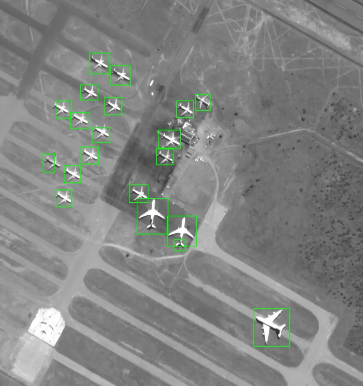
This is the stage with the greatest value: detecting aircraft, vessels, vehicles, and buildings using YOLO-type models, and identifying changes against historical imagery using Siamese networks.
Satellogic says its Merlin constellation will classify every pixel onboard. That means the computing budget for an onboard NPU must account for the full image area multiplied by the real-time frame rate, starting at tens to more than 100 trillion operations per second (TOPS).
Change monitoring also requires historical feature vectors to be stored onboard, placing new demands on space-grade memory.
Stage 5: Smart Compression and Encoding
This goes beyond conventional JPEG compression to “semantic compression.” Target regions within detection bounding boxes are encoded at high quality to preserve detail, while background regions use low bitrates—or are replaced entirely by semantic labels.
AI-based region-of-interest (ROI) prioritization then orders the transmission queue, ensuring that limited bandwidth carries the most valuable information first.
A counterintuitive design principle underpins the entire pipeline: onboard processing aims to be sufficient, rather than all-purpose. Ground systems can run models with hundreds of billions of parameters, while a satellite may have only tens of TOPS and a few gigabytes of memory.
Onboard models therefore require aggressive compression through pruning, distillation, and quantization, as discussed in the second week of August, and must be optimized for a specific task. The philosophy of onboard AI is specialization.
3. The Hardware Behind the Pipeline
The trend is clear: commercial off-the-shelf (COTS) hardware combined with fault-tolerant design is taking over onboard AI processing.
Established terrestrial AI modules such as Jetson Orin, paired with the three layers of protection discussed in the fourth week of August—triple modular redundancy (TMR), error detection and correction (EDAC), and watchdog timers—can deliver ten times the computing performance at one-tenth the cost. Planet has even brought Docker containers onboard its satellites. The era of software-defined satellites has arrived.
4. The Scheduling Brain Above the Pipeline
A single pipeline addresses how to process one image. A constellation must address how to schedule tens of millions of observation requests. The computing requirements of this mission-planning layer are often overlooked, yet are critical.
Onboard mission replanning: Merlin’s constellation architecture follows a sequence: detect an anomaly, communicate through inter-satellite links, and task a higher-resolution satellite to take follow-up imagery. This requires onboard algorithms that assess priorities and schedule observations without waiting for ground commands.
Onboard model updates: Satellite AI models need continuous updates as seasons, regions, and target types change. Uplink bandwidth is only a small fraction of downlink bandwidth. Compressing model differences, or delta updates, into kilobyte-scale uploads remains a frontier challenge.
Store-and-forward and opportunistic downlink: Processing results are stored onboard until the satellite passes over a ground station. Future inter-satellite links could relay those results to the most suitable station, turning the entire pipeline into a globally distributed system.
As more processing moves into orbit, the practical question for users remains the same: how to obtain useful information at a cost that makes sense. Drawing on China’s expanding satellite capacity, STARPATH GLOBAL offers competitively priced imagery and helps customers choose the resolution that fits their industry and monitoring needs. To explore suitable data sources and delivery options, discuss your requirements with STARPATH GLOBAL. Teams new to remote sensing can also apply to the Pioneer Partner Program, where our Forward Deployed Engineers help put satellite data to work and train staff to use it.