
At ADIPEC 2026 in Abu Dhabi, Weatherford President and CEO Girish K. Saligram said some oilfield service tasks that once required four to eight people are now performed autonomously. Siemens President and CEO Roland Busch argued that extending such gains across industrial operations requires companies to rethink how work gets done. In a separate panel, executives from SLB, DP World, and Inception42 explored the same question from different angles, from improving a routine decision about where to place a shipping container to the prospect of drilling at remote sites without personnel physically present.
Weatherford Sees Early Gains in Oilfield Operations
Saligram pointed to drilling as an area where AI is already helping operators make decisions. By analyzing subsurface information, teams can better anticipate the conditions a well may encounter, identify potential problems earlier, and make more informed decisions about where to drill. He also highlighted the use of AI to reinterpret seismic data and optimize production, giving operators another way to extract value from information they have already collected.
The Weatherford examples span two kinds of work. In one, AI helps specialists interpret complex data before making a decision. In the other, automation takes over service tasks that previously required a crew. Saligram described these as early gains and said industrial AI was still at an early stage.
Siemens Argues for Redesigning the Work Around AI
Busch said the benefits of adding a digital assistant to an existing workflow would be limited if the underlying process stayed the same. He argued that companies should examine how the work is done, where decisions are made, and how AI can be built into the systems that support those decisions. In manufacturing, that could affect how teams design products, operate plants, and adapt production when requirements change.
Doing that requires industrial data. Busch distinguished the engineering, design, and operating information needed for these applications from the language-based material commonly used to train general-purpose models. Access can be difficult because companies may be reluctant to share data that contains intellectual property. Operators therefore need to make specialized information available to the system while retaining control over how it is used.
Busch projected that AI could improve plant productivity by 20% and cut product development cycles in half. He also pointed to potential gains in energy efficiency and manufacturing flexibility. He linked automation and robotics to supply-chain resilience, arguing that they could make local manufacturing more competitive. As some repetitive, rule-based jobs disappear, he said, employers will need to invest in retraining for work such as robotics programming and automated operations.
Owning a Model Is Only One Part of Controlling Industrial AI
Domyn founder and CEO Uljan Sharka focused on what happens when a company puts proprietary information into an AI model. Once the model has been trained on that information, he argued, the company cannot simply take the information back out. He favored a more decentralized approach that combines open models with infrastructure companies can control independently. As an example of what is becoming possible, he cited a four-billion-parameter language model trained on a European supercomputer in 45 days.
Sharka added that owning a model still leaves a company dependent on the providers of the infrastructure that runs it. For critical operations, he advocated combining model outputs with verified information and established analytical methods. That gives operators a way to trace a finding back to the data and methods behind it.
From Container Placement to Remote Drilling
In a separate ADIPEC panel on digital transformation, DP World Group Vice President of AI and Data Science Som Dutta advised companies to start with a few high-value applications and agree on the objective with leadership before committing resources. DP World uses AI across ports, terminals, and logistics, as well as in finance, procurement, and commercial workflows. Dutta used container placement as an example. A better placement decision can save time and effort when a container has to be retrieved. Repeated across many movements, small improvements to that decision can add up.
SLB President of Digital Rakesh Jaggi described a more ambitious possibility. Satellite connectivity could keep a remote site connected, edge AI could process information in the field without sending every decision back to an office, and robotics could carry out physical tasks. In combination, he said, those technologies could make it possible to drill at remote onshore or offshore sites without personnel physically present. He also cautioned that errors can have severe consequences in drilling, which helps explain why adoption in day-to-day operations may proceed more gradually.
Inception42 CEO Ashish Koshy emphasized that agents need clean, connected data to work across different systems and that people need to retain control when agents act on that information. He also highlighted cybersecurity as a growing part of deployment. AI can help security teams identify and address vulnerabilities, while the systems themselves need protection as they gain access to operational data and tools. For an operator evaluating a pilot, the panel’s examples suggest a concrete starting point. Identify the recurring decision the system should improve, then test whether its output reaches the right people in time to change what they do.
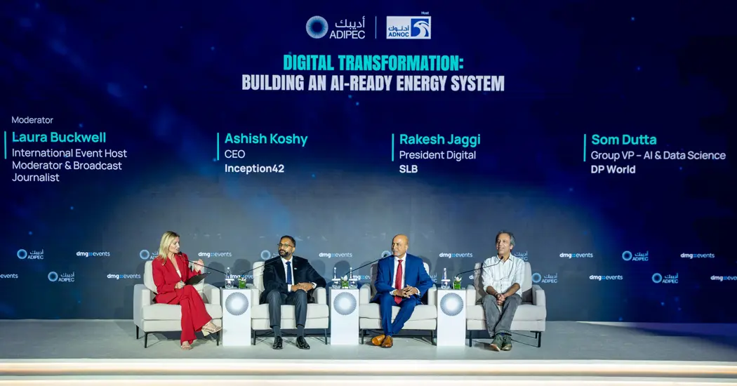
Image: Panelists at ADIPEC 2026 discuss where AI can improve energy operations and what it would take to deploy it in critical workflows.
How to Evaluate a Satellite Monitoring Pilot on a Pipeline Corridor
For a pipeline operator, the decision could be as specific as which signs of new construction near the right-of-way should trigger a field check? The pilot can start with one type of activity, such as excavation or new access roads, on a section where the operator has current route maps, work permits, and inspection records. Optical satellite imagery provides a record of visible changes. The operator’s records help determine which changes are expected and which need investigation.
Agree on What the Pilot Needs to Detect
Before selecting imagery, the operator and monitoring team can define the corridor to review, the smallest change that would affect an inspection decision, and how quickly an alert needs to reach the integrity team. A new access road and a narrow excavation may call for different image resolutions. Monitoring frequency also needs to reflect how long an activity is likely to remain visible and how soon the field team can act.
Coverage should be measured against the actual pipeline corridor. An image may cover the full route on a map while cloud, shadow, or gaps make individual sections unusable. The pilot should record which sections were observable in each cycle and which still need another acquisition or a field check.
Measure Confirmed Alerts and Missed Events Separately
Every alert should give the reviewer enough information to make a decision, including the location or pipeline chainage, the dates of the images, and a before-and-after comparison. The integrity team can classify the finding as authorized work, activity that needs follow-up, or a change unrelated to the pipeline. An alert can correctly identify construction even if the operator has already approved it.
The operator should also compare the alerts against known events from work permits or patrol records. Reviewing alerts shows how often flagged changes were real. Checking independently recorded events shows whether the system missed activity it was expected to detect under usable imaging conditions. Together, these checks reveal whether the problem lies in image coverage, detection, or how the alert was interpreted.
Check Whether the Alert Reaches the People Who Can Act
A field team needs to know where to go, why the change matters, and who should receive the result. The pilot can track the time from usable image acquisition to alert delivery, then from alert delivery to a decision on whether to dispatch a crew. Separating those intervals helps the operator see whether delays arise in imagery collection, analysis, or internal review.
That is where Busch’s point about redesigning the process becomes concrete. If reviewers must copy coordinates from a report into a separate work-order system and field findings never make it back to the monitoring team, the workflow will be difficult to expand. A pilot is ready for broader deployment when the operator can repeat the process across different sections, document why alerts were escalated or closed, and use field findings to refine future reviews.
Operators designing a pilot can contact STARPATH GLOBAL to define which changes matter, select imagery resolution and acquisition frequency around those targets, and agree on what each alert should contain. Deliverables can include dated coverage maps, geolocated findings, and before-and-after imagery that integrity teams can use to assign and close field checks.