
Pixxel is advancing next-generation Earth observation capabilities through its growing constellation of hyperspectral imaging satellites, designed to deliver high-resolution spectral intelligence for environmental monitoring, infrastructure analysis and resource management. Headquartered in Bengaluru, India, the company is developing a satellite network that combines advanced sensing technologies with scalable space infrastructure to provide detailed insights into changes occurring across Earth’s surface. Pixxel’s hyperspectral imaging systems are designed to provide a deeper analytical layer beyond conventional Earth observation techniques. By capturing detailed spectral signatures across a broad range of wavelengths, the company’s satellites enable the identification of patterns, material compositions and anomalies that traditional optical imaging systems may not detect.

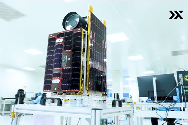
Pixxel’s satellite constellation is built around hyperspectral imaging technology, which captures reflected light across 37 to more than 100 narrow and contiguous spectral bands spanning the visible to short-wave infrared (SWIR) spectrum. Unlike conventional multispectral systems that collect data across a limited number of broad bands, hyperspectral sensors generate detailed spectral profiles for each observed object or surface. This approach enables the detection of subtle variations in vegetation health, soil composition, mineral presence, water quality and infrastructure conditions. By analyzing the unique spectral fingerprint of materials, Pixxel’s systems support high-precision applications that require accurate identification and monitoring of environmental and industrial changes. The company is developing its constellation using proprietary in-house hyperspectral sensors, engineered to deliver high-quality data while maintaining compact and lightweight satellite architectures. This design strategy allows Pixxel to optimize performance while reducing production complexity and launch costs.
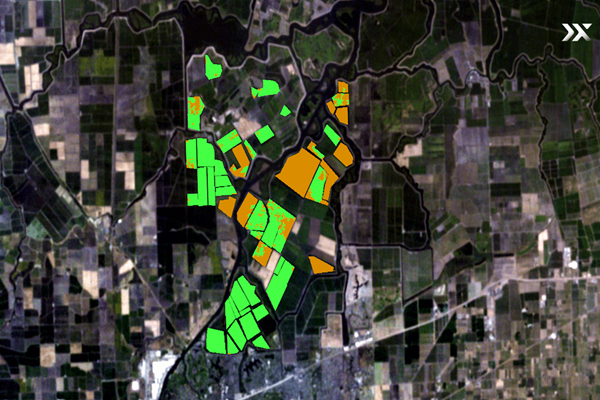
The satellites are configured to focus on high-priority geographic regions and customer-defined targets, enabling efficient tasking and targeted observation. This operational flexibility supports applications requiring frequent revisit rates and timely data acquisition. A major advantage of hyperspectral imaging lies in its ability to perform early-stage change detection by capturing highly detailed spectral data that reveals anomalies and subtle variations not typically visible through conventional imaging systems. Pixxel’s hyperspectral satellites support a broad range of monitoring applications, including environmental and ecosystem assessment, agricultural and vegetation monitoring, infrastructure inspection and analysis, resource exploration and management, as well as supply chain and industrial monitoring. By continuously observing Earth’s surface with high spectral fidelity, the constellation enables organizations to identify emerging changes more accurately and respond more effectively to evolving environmental, operational and industrial conditions.
Pixxel’s hyperspectral data provides a more comprehensive understanding of Earth’s surface composition and environmental conditions. By combining spectral analytics with high-resolution imagery, the constellation enables industries and institutions to make more informed decisions regarding resource allocation, environmental sustainability and operational planning. This approach supports efforts to improve efficiency in sectors such as agriculture, mining, climate monitoring and infrastructure management, where accurate and timely Earth observation data is increasingly important.
The company’s constellation strategy emphasizes scalability and cost efficiency, leveraging lightweight satellite platforms and streamlined deployment models. By reducing the cost of accessing hyperspectral data, Pixxel aims to expand the availability of advanced Earth observation capabilities to a broader range of commercial and institutional users. Pixxel is positioning hyperspectral imaging as a critical component of future environmental and industrial monitoring. Through the constellation of advanced satellites and proprietary sensor technologies, the company is enabling a more detailed understanding of Earth’s dynamic systems. By delivering high-resolution spectral intelligence with broad geographic coverage and flexible tasking capabilities, Pixxel’s hyperspectral constellation supports the transition toward more informed, resilient and data-driven decision-making across industries and governments.
About Pixxel
Pixxel is an India-based space technology company focused on hyperspectral Earth observation and geospatial analytics. Headquartered in Bengaluru, India, the company develops satellite constellations and imaging technologies designed to capture high-resolution spectral data for environmental, industrial and resource monitoring applications. Pixxel’s hyperspectral satellites are equipped with proprietary sensors capable of capturing data across dozens of narrow spectral bands spanning the visible and short-wave infrared spectrum. These systems enable detailed analysis of Earth’s surface by identifying unique spectral signatures associated with materials, vegetation, water and infrastructure. The company’s technology supports applications such as agriculture monitoring, climate and environmental analysis, infrastructure assessment, mining and resource management. By combining advanced hyperspectral imaging with scalable satellite architectures, Pixxel provides data-driven insights for commercial and institutional users.