A satellite image can show that a vessel was present at a particular place and time. It cannot, by itself, show where that vessel went next. For a port or maritime team, “detecting a vessel,” “matching its identity,” and “tracking its route” are three different deliverables.
Detection, Matching, and Tracking Answer Different Questions
Detection asks: Is there an object resembling a vessel in this image? Synthetic aperture radar (SAR) can observe maritime areas at night and through cloud cover. Optical imagery can add visible details when lighting and weather allow. A detection is tied to the image’s acquisition time and footprint; it does not automatically establish the vessel’s identity.
Matching asks: Does a detected object correspond to a particular AIS-reporting vessel? Analysts compare the image with historical Automatic Identification System (AIS) messages, accounting for the difference between their timestamps. Vessel speed, heading, dimensions, nearby traffic, and the quality of both records can help assess a candidate. A plausible match is still an assessment, especially where several vessels are close together.
Tracking asks: How did the vessel move over a period of time? This requires a sequence of position reports or repeated observations that can be connected with sufficient confidence. AIS may provide a route for a reporting vessel. Satellite images can check selected points along that route or reveal activity missing from the available AIS record. Two isolated image detections do not necessarily establish that the same vessel appears in both.
Two Minutes Can Matter: A SAR and AIS Example
A 2025 study in Remote Sensing examined a Sentinel-1A SAR image acquired off northeastern Brazil on 29 August 2019 at 08:01 UTC. Researchers detected the bulk carrier ELENA in the image. Its historical AIS record placed it at another position at 07:59 UTC, travelling at 14 knots. The AIS position and the detected SAR target were approximately 889 metres apart.
That distance is consistent with a vessel moving for two minutes at the reported speed. Plotting the 07:59 AIS point directly on the 08:01 image, without accounting for elapsed time, could make a valid candidate appear unrelated. Conversely, proximity alone would not prove a match if several vessels occupied the area. The study’s example is a time-specific detection and AIS match, not a continuous, real-time satellite track.
Why Does a Match Become Uncertain?
- Time difference: An AIS point recorded before or after the image may be far from the vessel’s position at acquisition. Estimating the intervening position becomes less reliable if the vessel turns, slows, or stops.
- Observation gaps: A vessel can travel beyond the next image footprint before another usable acquisition. Revisit opportunities, tasking, clouds for optical sensors, and the area covered all affect whether it is seen again.
- Incomplete AIS history: A missing message may reflect reception coverage, reporting gaps, equipment status, or other causes. An unmatched image detection is therefore a lead for review, not proof that a vessel deliberately switched AIS off.
- Ambiguous detections: Closely spaced vessels, coastal structures, sea conditions, and image artefacts can complicate interpretation. An automated SAR candidate may also be a false alarm.
A Practical Workflow for a Maritime Team
- Record the image acquisition time and footprint. Use a consistent time standard, such as UTC, and check whether the area of interest was actually imaged.
- Detect and review targets in SAR or optical imagery. Preserve each target’s location, image time, detection quality, and relevant visual or radar characteristics.
- Retrieve historical AIS records around that time. Examine message timestamps and quality; where suitable records bracket the acquisition, estimate each reporting vessel’s position at image time.
- Rank candidate matches. Compare estimated positions with image detections, then check speed, course, vessel size, and competing candidates. The acceptable time and distance windows should reflect local traffic and data quality.
- Review uncertain cases. An analyst checks the image, AIS history, nearby targets, and any available coastal radar, port, or vessel records before assigning a status.
These statuses make the scope of a monitoring service clear. A detection report documents what appeared in an image. An identity assessment explains the supporting evidence and uncertainty. A route product requires enough observations to connect movement over time. For a separate discussion of how multiple data sources can support investigations when vessel reporting is incomplete, see When Vessels “Disappear” from the Map.
STARPATH GLOBAL can help maritime teams define an area of interest, source suitable SAR and optical imagery, and design an image-to-AIS review workflow around their existing data. To discuss the evidence and reporting frequency your operation needs, contact our team.
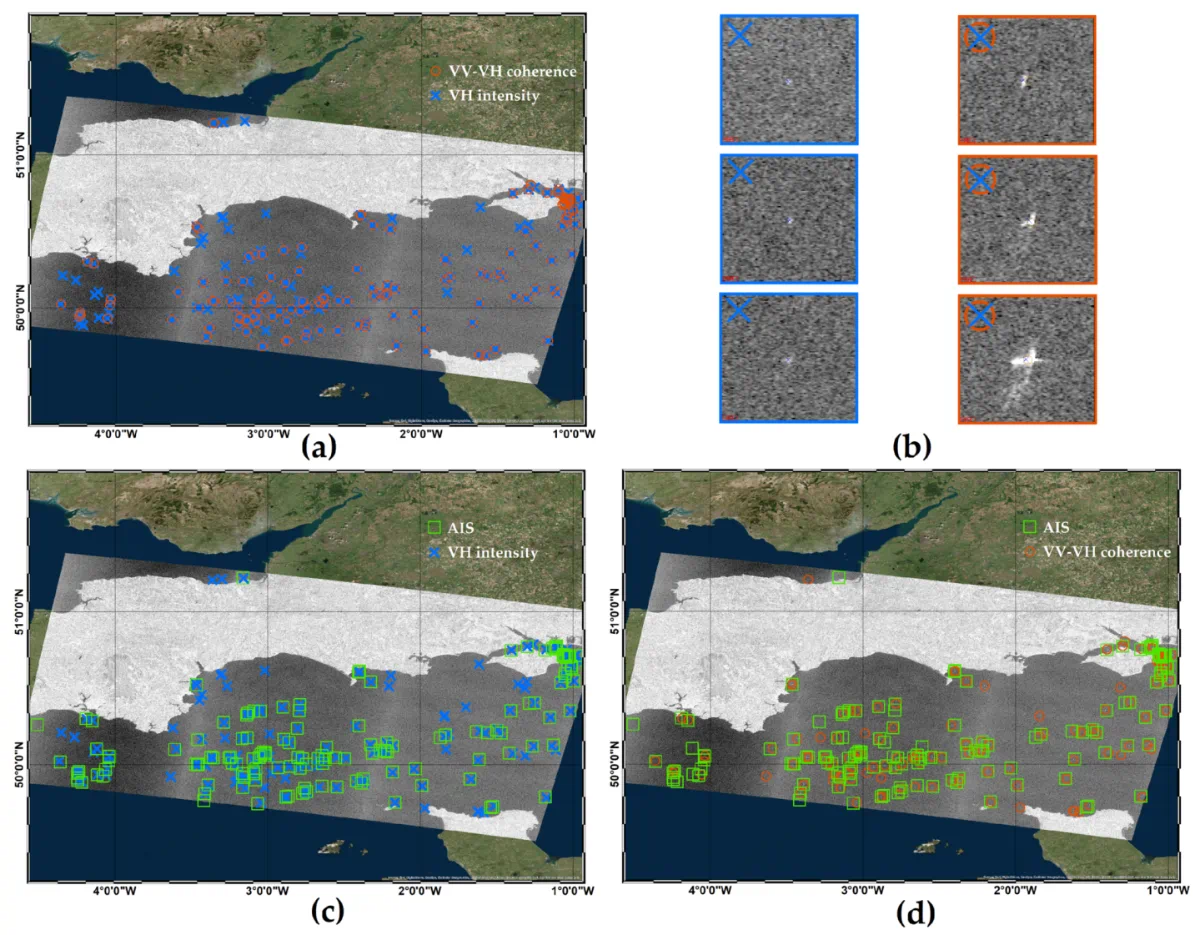
Feature image: Illustration of the AIS-SAR cross-comparison for a Sentinel-1 IW image acquired over the English Channel area (24/10/2017): (a) Vessels detected by the CVV−VHun−norm-based detector and the CFAR applied to IVH, (b) signatures of vessels detected by only constant false alarm rate (CFAR) IVH (left column) and by both CVV−VHun−norm-based detector and CFAR IVH (right column), (c) vessels detected by the CVV−VHun−norm-based detector and AIS interpolated positions, (d) vessels detected by CFAR applied to IVH and AIS interpolated positions.