In the summer of 2026, drought across Europe and the developing El Niño once again drew attention to risks affecting agricultural production and food security.
On August 13, the Associated Press reported that persistent heat and drought were affecting agricultural production across Europe, putting crops ranging from potatoes in the Netherlands and maize in Bosnia to grapes in Italy under pressure. On August 6, Reuters cited a World Food Programme scenario estimate that, if the intensifying El Niño reaches its projected strength, nearly 49 million additional people worldwide could face acute food insecurity by the end of 2027. The effects will not be uniform: some agricultural regions may face drought, while others could experience heavy rainfall or flooding.
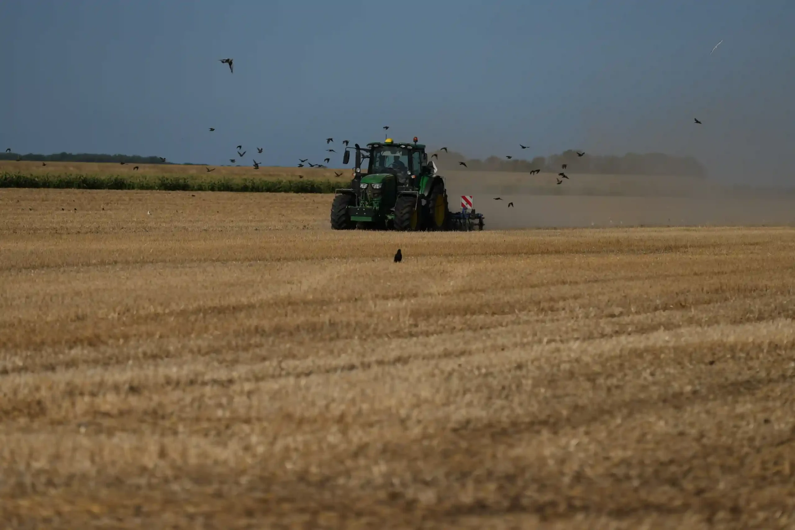
Farmer Maarten Janse drives his tractor on a drought stricken wheat field in Wolphaartsdijk, Netherlands, Tuesday, Aug. 11, 2026. (AP Photo/Virginia Mayo)
These risks ultimately converge on one of agriculture’s most fundamental constraints: water. As exposure to extreme weather increases and water resources become more constrained, the focus is gradually shifting from “how to obtain more water” to “how to manage existing water supplies more precisely.”
A global modelling study published in Nature Food in April 2026 estimated that, under 1.5°C and 3°C warming scenarios, global irrigated area would need to expand by approximately 13% and 47%, respectively, to offset the effects of warming on wheat, maize, rice and barley yields. However, only around 60% of the cropland requiring additional irrigation has the potential to be irrigated without generating water scarcity or depleting local freshwater resources.
Expanding irrigation is not the only way to respond to climate risk. The study does not evaluate irrigation-monitoring technologies directly. Operationally, however, its findings strengthen the case for managing existing irrigation resources more precisely where additional water supplies are constrained. For large agricultural operators, this translates into several practical questions: Which areas are receiving irrigation? Are moisture responses consistent with expectations? Which fields should be inspected first?
Satellite remote sensing offers a new way to observe these conditions. Explore Satellite Remote Sensing Applications in Agriculture →
Why a Crop Anomaly Is Not Necessarily an Irrigation Anomaly
Crop health monitoring has become an important part of precision agriculture. Using multispectral satellite imagery, agricultural operators can observe changes in vegetation indices and crop development, identifying areas where anomalies may be associated with drought stress, disease or other factors. These observations provide valuable clues for investigating possible causes and planning field inspections.
However, answering the question “Is the irrigation system functioning as expected?” requires more than observing the crop’s visible condition.
Poor crop performance could result from insufficient rainfall, inadequate or uneven irrigation, a local equipment malfunction or differences in soil conditions. Conversely, healthy crop growth does not necessarily mean that irrigation is well managed or water use is efficient. Recent rainfall and differences in the water-holding capacity of inpidual fields can also influence crop performance.
Crop monitoring is better suited to answering, “How is the crop canopy performing?” Irrigation monitoring must go further and ask, “When and where did a moisture response occur, and was it consistent with expectations?”
Agriculture already uses several direct irrigation-monitoring methods, including soil-moisture sensors, flow measurements, field sampling and manual inspections. These approaches provide detailed local information and remain essential for equipment checks and field-level management.
The real challenge emerges when monitoring has to scale. When an agricultural company manages large numbers of dispersed fields, plantations or production sites, increasing coverage and monitoring frequency often requires more sensors, field personnel, travel time and equipment maintenance. The issue is not that conventional methods cannot monitor irrigation, but how to balance coverage, monitoring frequency and field resources as operations expand.
For large agricultural assets, one practical approach is to observe the wider area first and then concentrate field personnel and equipment on locations that warrant closer inspection. Satellite remote sensing can add this large-area, continuous observation layer.
How Satellites Identify Irrigation Activity
A satellite cannot see an inpidual irrigation pipe from space, nor can a single image determine whether a particular piece of equipment is working correctly.
What satellites can observe are the changes that irrigation leaves in the soil, vegetation and land surface.
Optical satellites can capture vegetation conditions and crop responses following irrigation. Vegetation indices such as NDVI and EVI can characterise changes in vegetation greenness and canopy condition over time, helping identify areas that deviate from historical baselines or neighbouring fields. However, these indices generally cannot determine the cause of an anomaly on their own.
SAR provides a different type of information. Radar observations are sensitive to changes in soil moisture, vegetation and surface conditions. They do not rely on natural illumination and offer advantages under cloudy conditions, complementing optical data. However, SAR backscatter is also affected by surface roughness, vegetation structure and observation conditions. Soil-moisture estimates therefore usually require modelling and validation against ground data.
Time series are equally important in satellite-based irrigation monitoring. A single image rarely captures the full irrigation process. Observations must be compared before and after irrigation and across the subsequent period to understand changes in soil and vegetation. Combined with rainfall and other weather data, these observations provide additional evidence for assessing whether a change is more likely to have resulted from natural rainfall or artificial irrigation.
Satellite irrigation monitoring is therefore not about directly “seeing water.” It involves identifying the spatial and temporal signatures that irrigation leaves in soil, vegetation and their changes over time.
Two studies published in 2026 illustrate what this approach may be able to achieve under specific conditions.
Case Study: Identifying Field-Scale Irrigation Dynamics
A study published in the August 2026 issue of Agricultural Water Management analysed changes in irrigated agriculture across Australia’s Namoi catchment from 2019 to 2025. The researchers combined the fraction of reference evapotranspiration, or ET₀F, with the Enhanced Vegetation Index, or EVI, rainfall and other information to distinguish irrigated from rainfed cropland.
The study addressed a central challenge: differentiating crop growth driven by rainfall from growth resulting from artificial irrigation. Vegetation greenness alone is generally insufficient for this purpose. The researchers therefore combined vegetation, evapotranspiration, rainfall and other climate signals to identify potentially irrigated areas.
The study found substantial year-to-year variation in the extent of irrigation across the Namoi catchment. Satellite data could support the identification of potentially irrigated areas and help establish an initial spatial baseline of irrigation extent. According to the authors, the method is particularly suitable for identifying irrigation hotspots, mapping irrigation extent and prioritising areas for field-level monitoring.
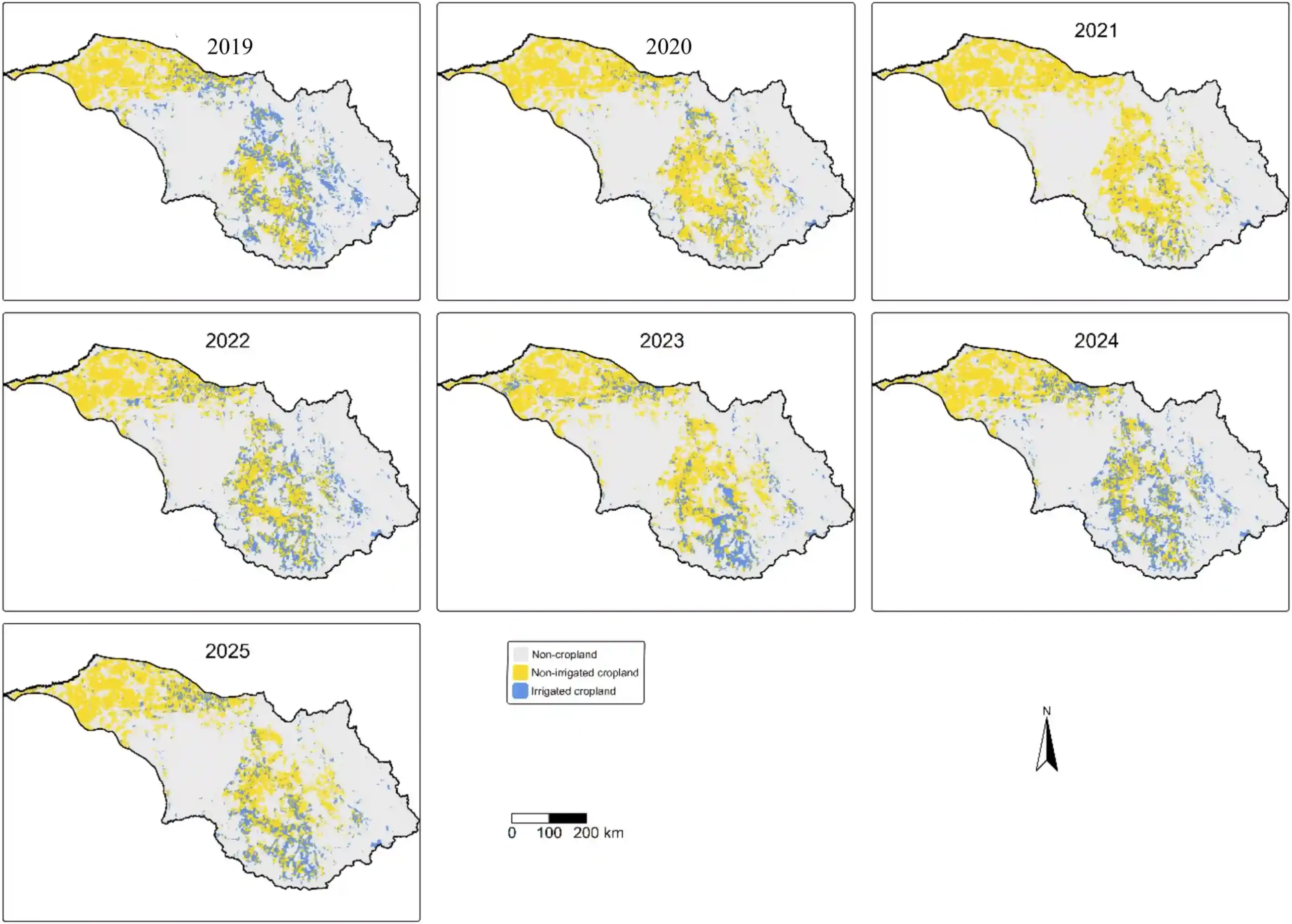
Spatial distribution of mapped irrigated cropland during the summer irrigation season across 2019–2025 in the Namoi catchment. Irrigated cropland (blue) is shown overlaid on all cropland (yellow) while non-cropland areas are shown in grey.
Validation showed that the method was more effective at highlighting potential irrigation areas than at producing a complete inventory. It could miss some irrigated fields, and its results were sensitive to the analytical thresholds used. It is therefore not suitable for independently producing a definitive irrigation inventory. However, it can serve as a low-cost, large-area screening tool that helps identify locations requiring further investigation.
For companies managing large agricultural portfolios, monitoring hundreds or thousands of fields does not necessarily mean applying the same level of field inspection everywhere. Satellite observations can be used to examine the wider area first, allowing field resources to be prioritised for locations that require closer attention.
Satellites can help answer, “Where should we look?” Field teams can then determine, “What is actually happening?”
Case Study: Can Satellites Detect Uneven Irrigation and System Anomalies?
While the first study focused on identifying where irrigation might be occurring, another 2026 study published in Computers and Electronics in Agriculture examined whether irrigation was being applied uniformly and whether the system showed signs of malfunction.
The study focused on a vineyard drip-irrigation system, combining Sentinel-1, Sentinel-2 and Planet satellite data with ground measurements to assess irrigation uniformity and potential system faults.
The researchers used surface soil-moisture estimates derived from Sentinel-1 to observe moisture changes after irrigation. They then combined these estimates with NDVI data from Sentinel-2 and Planet to examine irrigation outcomes from the perspective of vegetation response.
The results showed that Sentinel-1-derived soil-moisture estimates could reveal post-irrigation changes relatively quickly, while vegetation responses in optical imagery appeared later. The researchers also developed satellite-derived irrigation-uniformity indicators that showed potential to flag areas where irrigation performance differed from expectations. Some indicators performed better than others, reinforcing the need for local validation before operational use.
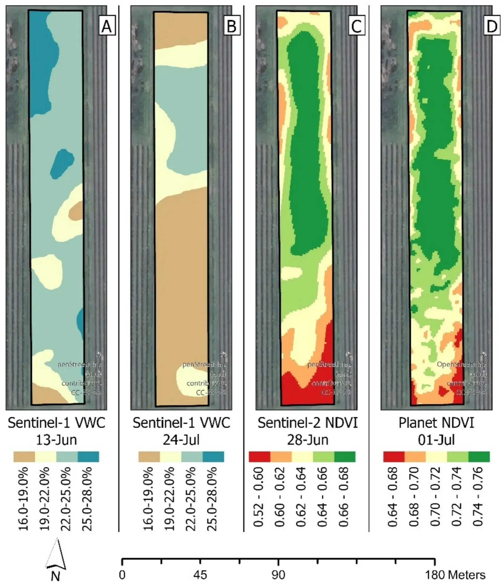
Spatial distribution maps derived from Sentinel-1 VWC on June 13th and July 24th, Sentinel-2 NDVI on June 28th, and Planet NDVI on July 1st. Each map illustrates the variability of water content or vegetation indices across the vineyard.
This suggests that satellite applications may extend beyond identifying potentially irrigated areas to detecting locations where irrigation performance differs from expectations.
In this vineyard case, the satellite indicators could not identify the exact pipe or component responsible for a malfunction. Operationally, however, the detected spatial anomalies could help field teams narrow the area requiring inspection. Because the study examined a specific vineyard and drip-irrigation system, applying the same method to other crops, soils or irrigation systems would require local validation. Rainfall-induced moisture homogenisation may also weaken anomaly signals.
For organisations considering multisource satellite data for precision agriculture, irrigation anomaly screening or large-area farmland monitoring, the real question is not simply how to obtain an image. It is how to select the right data types, observation frequency and analytical approach for the monitoring objective. Explore satellite data for agricultural monitoring →
From “Viewing Fields” to “Finding Problems”: How Satellites Can Improve Irrigation Monitoring
Taken together, the two studies point to a common approach: continuously observe large agricultural areas using satellites, screen for potential anomalies through changes in soil, vegetation and time-series signals, and then use sensors, weather information and operational records to help field teams confirm the cause.
Large-area observation → Change detection → Priority-area screening → Field validation → Management adjustment
In this workflow, satellites serve as a remote screening layer. Their value is not in promising a fixed percentage reduction in costs, but in expanding the area that can be observed continuously and making field inspections more targeted. Actual performance will still depend on field size, data resolution, revisit frequency, weather conditions and field-response processes.
From Satellite Monitoring to Agricultural Decisions: First Validate Which Signals Have Business Value
Moving from potential anomaly detection to an operational management process requires scenario-specific validation. The questions that need to be tested will differ across farms, plantations and production sites:
- Which changes in soil and vegetation reflect local irrigation activity?
- Can the effects of natural rainfall be distinguished from those of artificial irrigation?
- Are the spatial resolution and observation frequency sufficient to detect anomalies within inpidual fields?
- Can the screening results help field teams avoid unnecessary inspections and identify investigation priorities more quickly?
These questions are difficult to answer by simply purchasing a collection of satellite images. A more practical approach is to begin with representative fields and a clearly defined monitoring problem. Satellite observations can then be compared with weather data, ground measurements and field records to determine which signals have genuine operational value.
STARPATH GLOBAL’s Forward Deployed Engineering team can work with agricultural organisations to conduct this validation. Based on crop type, irrigation method, field size and existing monitoring processes, the team can select an appropriate data combination, produce initial anomaly-screening results and compare them with weather information, ground measurements and field records. If the results provide useful evidence for field inspection and irrigation management, the method can then be extended to additional fields or production sites to establish a continuous monitoring process.
The value of satellite remote sensing lies not only in enabling agricultural organisations to observe a wider area, but also in helping them detect change earlier and direct limited field resources towards the locations that most need inspection.
If you manage dispersed farmland, plantations or multiple production sites, validation can begin with one representative area and one clearly defined monitoring problem.
Start an Agricultural Water Monitoring Feasibility Assessment.
References
- The Associated Press:https://apnews.com/article/b44ab4a0d37c1ef7c4f66de8effe567b
- World Food Programme: https://www.wfp.org/publications/el-nino-fao-wfp-joint-anticipatory-action-appeal-june-2026-march-2027
- Nature Food: https://www.nature.com/articles/s43016-026-01338-9
- Agricultural Water Management:https://www.sciencedirect.com/science/article/pii/S0378377426005342
- Computers and Electronics in Agriculture:https://www.sciencedirect.com/science/article/pii/S0168169926003170