Remote sensing technology has given agricultural censuses “eyes in space,” but satellite imagery alone cannot produce agricultural data with 100% accuracy. Misaligned field boundaries, omitted or duplicated polygons, crop misclassification, and cloud cover obscuring ground conditions are all unavoidable challenges in remote sensing interpretation.
These issues emerged during the remote sensing survey verification for China’s Fourth National Agricultural Census in 2026, which involved an enormous number of field polygons across vast areas and multiple batches. Under the traditional workflow, staff interpreted imagery using disconnected tools and circulated verification results through paper documents and offline files. This approach was time-consuming and labor-intensive, making it difficult to balance operational efficiency, data quality, and multi-party collaboration—all of which posed significant challenges for large-scale field verification of agricultural remote sensing data.
To address these problems within a single system, a research team led by Li Qiangzi, Du Xin, and Zhu Jiajia from Division Three of the Aerospace Information Research Institute, Chinese Academy of Sciences, independently developed the Fourth National Agricultural Census Remote Sensing Survey Results Verification Platform, hereafter referred to as the “platform.”
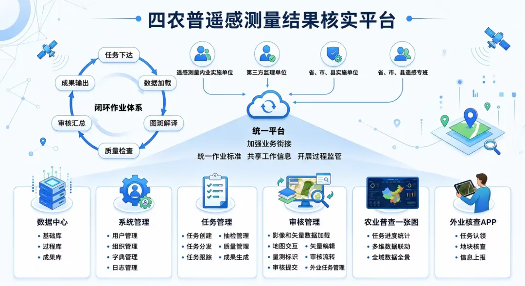
Overall architecture of Henan Province’s Fourth National Agricultural Census Remote Sensing Survey Results Verification Platform
How Are Massive Numbers of Tasks Assigned?
The first challenge in remote sensing verification is not how to edit a map, but how to distribute such an enormous workload in an orderly manner.
Built on a browser/server architecture, the platform allows provincial, municipal, and county-level remote sensing teams, together with office-based implementation units, to work within the same browser-based environment. There is no need to equip every reviewer with a dedicated professional graphics workstation. Once a task has been created, it can be divided systematically by geographic area, reviewer, and operational grid, enabling the entire process—from creation and assignment to confirmation and tracking—to be managed online.
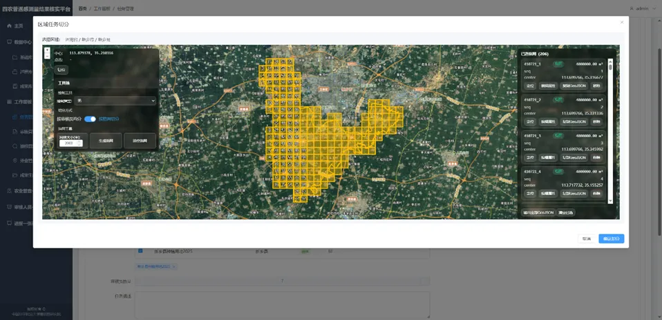
Standardized task creation and geographic division allow large-scale verification assignments to be rapidly distributed to individual districts and grids.
For large batches of tasks, the platform can also allocate work intelligently according to each reviewer’s existing workload and level of professional expertise. The system clearly shows who is responsible for each review, which area they are reviewing, and how far the task has progressed. Task organization that once relied on spreadsheets, files, and manual communication has been transformed into a digital workflow that can be scheduled and tracked.
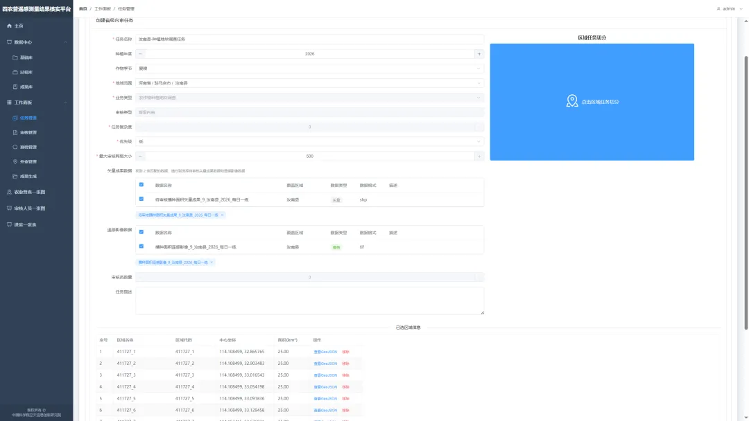
The platform intelligently distributes tasks based on workload and professional expertise.
How Are Massive Numbers of Polygons Verified?
Once tasks have been assigned, polygon interpretation becomes the real test of review efficiency.
High-resolution remote sensing imagery and the vector data awaiting review are overlaid on the same map. Reviewers can browse the task area grid by grid and compare the imagery with field boundaries, classification attributes, and spatial relationships. When a problem is identified, there is no need to switch repeatedly between different software applications. The platform provides integrated tools for adding and deleting vectors, editing vertices and attributes, adjusting boundaries, merging and splitting polygons, and subtracting overlapping areas.
Complex fields are especially prone to situations in which reviewers can identify a problem but struggle to correct it efficiently. The platform therefore provides lightweight tools tailored to agricultural remote sensing verification, including boundary adjustment, boundary smoothing, vector subtraction, and topology checks.
Before results are submitted, the system can also detect and flag topological errors such as self-intersecting and overlapping polygons. Tools for avoiding conflicts with fields in adjacent tasks, together with a crop interpretation knowledge base and reference cases from both office-based and field verification, provide reviewers with additional evidence and help reduce inconsistencies caused by differences in individual experience.
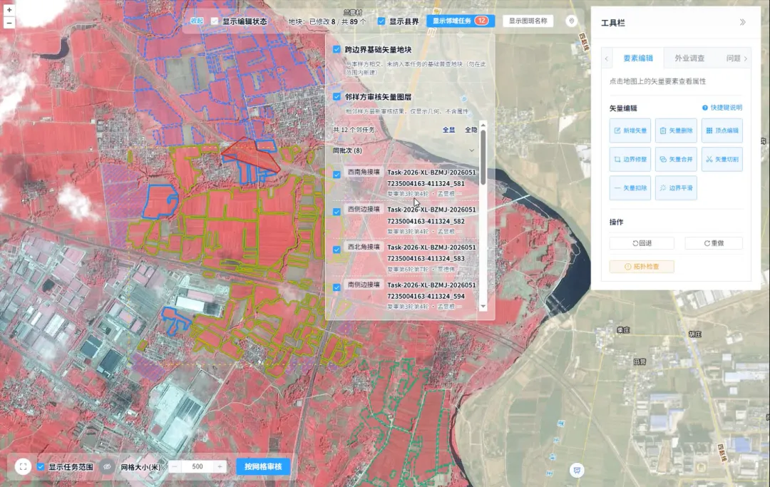
Vector-assisted editing and spatial topology checks support the accurate review of complex fields.
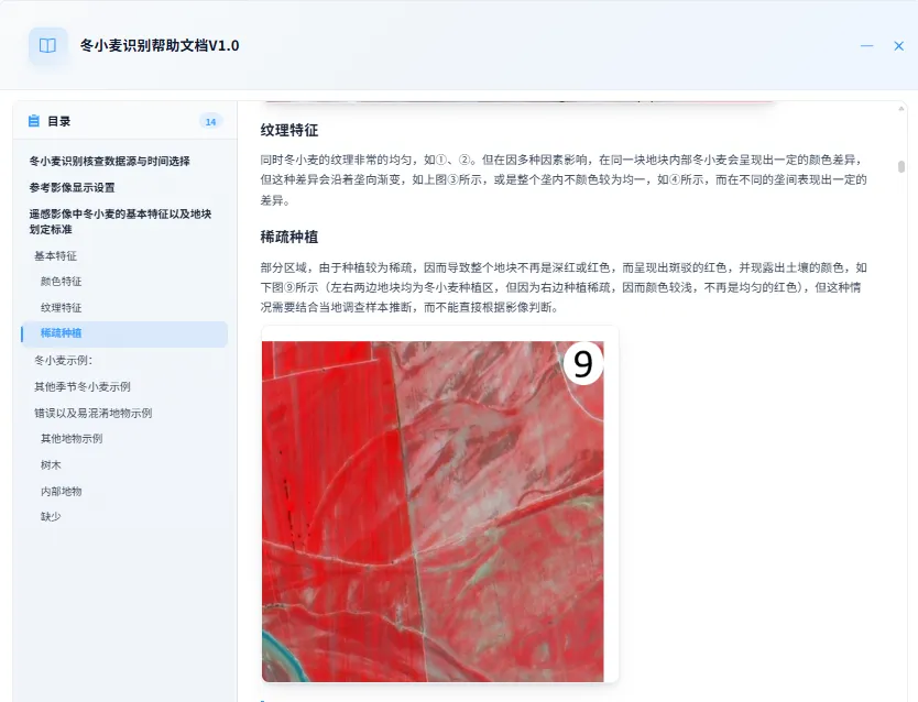
The crop interpretation knowledge base and reference cases assist reviewers in assessing difficult polygons.
What Happens When the Imagery Is Unclear?
Remote sensing can observe large areas, but imagery alone cannot always identify every field accurately.
When crop types appear similar, field boundaries are unclear, facilities obscure the land, or office-based reviewers have doubts about the results, repeatedly enlarging the image on a screen will not resolve the underlying problem.
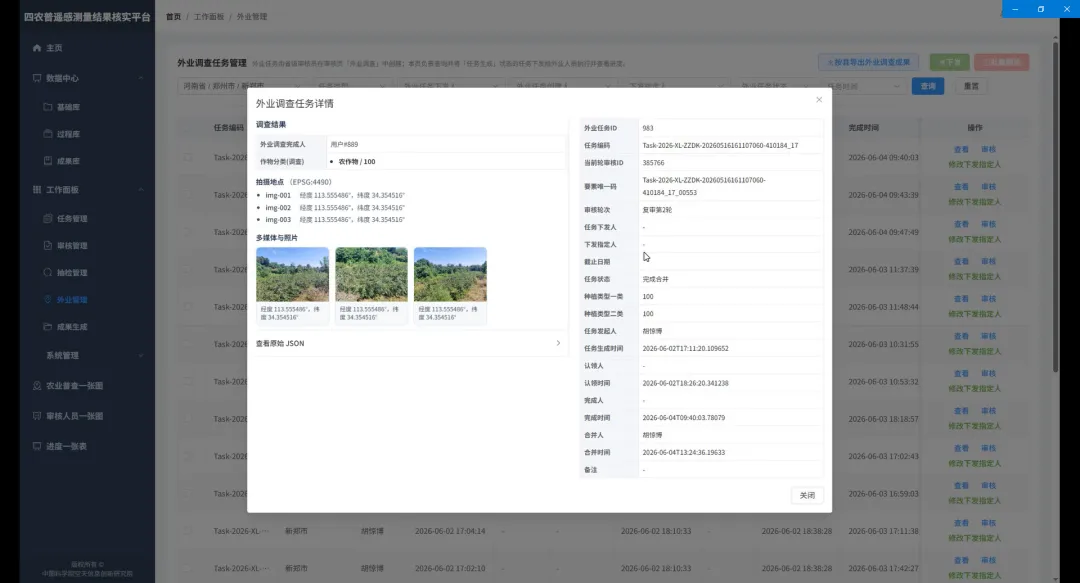
Office-based reviewers initiate field investigations and examine the verification results.
The platform directly connects office-based interpretation with field investigation. A reviewer can select a questionable field on the map and initiate a field survey, after which the assignment is sent to the field inspector’s mobile device.
Once on site, field personnel can locate the field, conduct an investigation, take photographic evidence, and submit their findings. Office-based reviewers can then examine the photographs, geographic coordinates, and survey conclusions before incorporating the verified information into the review results.
The entire process—from identifying something that cannot be determined from imagery, to inspecting it on site and writing the verified result back into the dataset—is completed within a single operational chain.

Receiving and claiming tasks on a mobile device
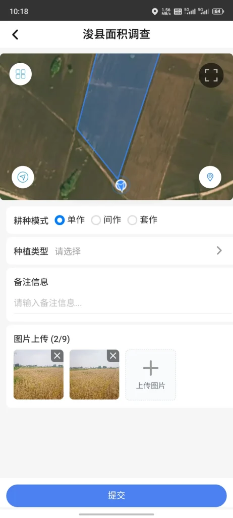
On-site positioning, photography, and results submission
How Is Data Quality Maintained?
Verifying remote sensing survey results does not end after someone reviews and edits the polygons.
Based on clearly defined responsibilities and permissions, the platform establishes a workflow consisting of county-level preliminary review, municipal-level reexamination, and provincial-level approval. Tasks can move through standardized stages such as reexamination, rejection, and field verification. Every time a task is claimed, edited, submitted, or reexamined, the system creates a record, making it possible to trace who reviewed it, what was changed, and what the final result was.
In addition to its tiered review process, the platform includes sampling inspection and quality-assessment mechanisms. Results may undergo provincial-level sampling inspections, municipal-level sampling inspections, and cross-reviews between counties. Task sampling, reviewer exclusion rules, and quality scoring help identify further problems.
Quality control is therefore embedded throughout the task workflow instead of being confined to a final inspection.
How Can Province-Wide Progress Be Monitored?
When hundreds or thousands of tasks are underway simultaneously, managers need to understand the overall situation. Which regions have finished their work? Which tasks are still being reexamined? Where are backlogs developing? Is the review workload distributed evenly?
The platform brings this information together through an agricultural census overview map, a reviewer overview map, and progress statistics.
Managers can examine task distribution, review status, and progress across different regions from a spatial perspective. They can also see which reviewers are online and how their workloads are distributed. Information that previously required repeated inquiries at multiple administrative levels and the manual consolidation of spreadsheets can now be viewed directly on the platform, providing an at-a-glance overview of province-wide operations and one-click access to progress information.
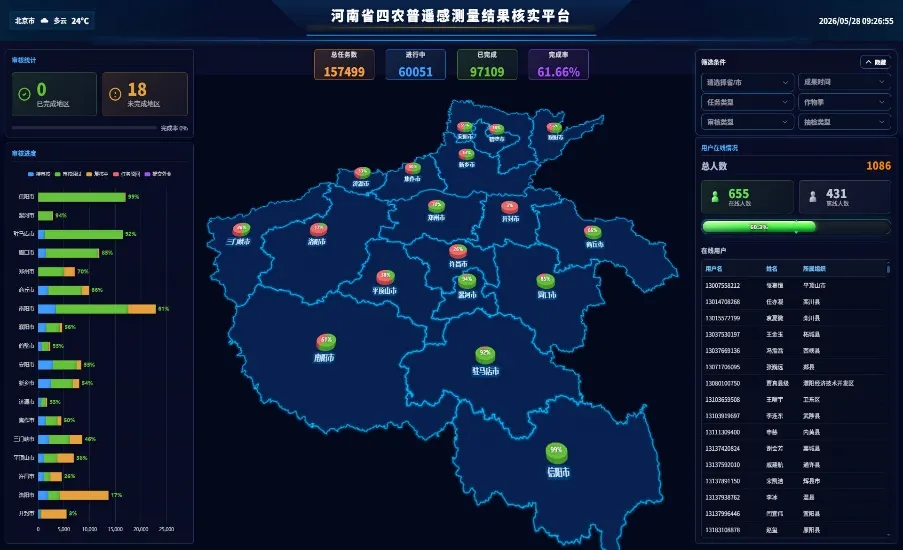
The agricultural census overview map brings together task progress and geographic distribution.
What Does Each Verification Task Leave Behind?
The value of verification extends beyond completing the current assignment.
The platform manages foundational data, process data, and final results in separate layers. Information generated during the workflow—including review edits, issue annotations, field inspections, sampling inspections, and quality assessments—is preserved at the same time. When a task is completed, it produces not only a set of results but also a fully traceable operational record.
More importantly, the system continuously collects verification cases, samples of difficult polygons, and expert arbitration decisions, gradually building an agricultural remote sensing verification sample database and knowledge base tailored to Henan Province. A problem solved today can become a reference for future interpretation, while experience gained during one census can be transformed into a reusable, long-term technical resource.
By harnessing technology, the platform enables tasks to be distributed online, polygons to be verified digitally, questionable results to be investigated in the field, and every step of the process to be recorded. It transforms isolated operations into province-wide collaboration by reorganizing previously fragmented personnel, data, tools, and workflows.
Every questionable field is assigned for resolution, every modification is supported by evidence, and every stage leaves a record. The platform ultimately ensures that remote sensing survey results are verified clearly, accurately, and thoroughly, providing strong technical support for large-scale agricultural remote sensing surveys.
As China’s increasingly efficient space manufacturing system brings greater satellite production capacity to the global market, international customers can access competitively priced satellites, payloads, and integrated space solutions. Explore STARPATH GLOBAL’s agricultural remote sensing solutions, or apply for our limited-availability, free FDE Pioneer Partner Program to develop a solution tailored to your project.